
Baillie-Grohman Canal
_1890.JPG)
The Baillie-Grohman Canal was a shipping canal between the headwaters of the
Geographic setting

The Baillie-Grohman Canal was suggested by the unusual geographic setting of the sources of the Columbia and the Kootenay Rivers. The Columbia River begins at
Rail construction in Canada and the United States made steam navigation possible in the Rocky Mountain Trench. There were two important
William A. Baillie-Grohman
In the early 1880s a wealthy European adventurer,
The provincial government refused to allow the diversion. However, Baillie-Grohman was able to obtain ownership of large areas of land in the Kootenay region, provided he engaged in certain forms of economic development, including construction of a shipping
Transport to the canal site
Baillie-Grohman arranged to have shipped to Golden a large amount of supplies, including complete equipment for a steam-powered sawmill, which was necessary to cut the lumber to build the canal locks and shelters for the workers at the canal. Baillie-Grohman also had hired a complement of workers, including a skilled millwright, to build the sawmill and supervise construction of the canal. But when the time came to transport the supplies and the people by water to Canal Flats, Duchess, then the only steamer available, was then sunk in the deepest part of the river up to her smokestack.
River transport was the only way Baillie-Grohman could move the heavy sawmill and construction equipment the 124 miles to Canal Flats. The provincial government required Baillie-Grohman to complete the canal by the summer of 1889, then two years in the future. If he did not finish the canal on time, he would not receive the land far downstream. With Duchess under water and no other transport in sight, the clock was running on Baillie-Grohman's dream. There was at this time in Golden a man named Jack Hayes who had collected the pieces of a potential steamboat. These included an unpowered heavy-duty railroad construction barge, a vertical boiler from a Manitoba steam plow, and machinery salvaged from an old tugboat. Hayes however lacked the skill to assemble these components into a steamboat. Baillie-Grohman's only option was to task his millwright to help Jack Hayes complete the Clive.[9]
Clive was much too heavy for the shallows of the Columbia River, which were often choked with snags, that is, dead trees which had become lodged in the bed of the river. Snags could block navigation or sink a vessel that might strike them. Under these conditions, it took Clive 23 days to cover the 100 miles from Golden to the point upriver where the sawmill could be unloaded.[9]
Construction of the canal and locks
As was common for construction projects in western North America at that time, the hard labor of building the canal was done by Chinese immigrant laborers. According to E.M. Sandilands, who worked on the canal, the project was fatally defective from the start, because nothing in the stipulations between Baillie-Grohman and the provincial government required Baillie-Grohman to dredge or prepare the approaches to the canal. All Baillie-Grohman had to do was to build the canal and locks . However, without proper approaches, it would be near-to-useless.
When these were completed, and after a ceremony enhanced by what Sandiland described as "a canoe well laden with the 'good cheer' demanded by such an occasion",[10] Sandiland was ordered by the foreman to break out the false dam which had been keeping the Kootenay River from flooding the works. With the aid of another worker he did so, and thus became, as he later realized, the man who made the entire Selkirk and Purcell mountain range into an island. With the canal in place, this entire huge alpine region was completely encircled by the Columbia River, the Arrow Lakes, the Kootenay Lake and River, and finally the canal itself.[11]
Size and cost
When on July 29, 1889[12] complete, the canal was 5,049 ft (1,539 m) long and 45 ft (14 m) wide. Baillie-Grohman had raised funds for the venture in England, and was reputed to have sunk a major part of his own considerable personal wealth into the financing syndicate. The locks alone cost $100,000, enough to build five or six steamboats the size of the 1897 upper Kootenay sternwheeler J.D. Farrell.
Limited use of canal
Despite its cost, the Baillie-Grohman canal was only transited three times by steam-powered vessels.
Transits of the Gwendoline in 1893 and 1894
In 1893, Armstrong built Gwendoline at Hansen's Landing on the Kootenay River, and took the vessel through the canal north to the shipyard at Golden to complete her fitting out.[1] By this time it appears that the canal had been damaged or deteriorated to the boat where at least some of the transit of Gwendoline had to be accomplished by pulling the vessel out of the water, partially dismantling the boat, and pulling her along on rollers.[13] Over the winter, Armstrong, it is reported, was able to prevail on the provincial government to expend funds to repair the canal.[14] In late May 1894 Armstrong returned the completed Gwendoline back to the Kootenay River, this time transiting normally the rehabilitated canal.[1][12][15][16]
Transit of the North Star in 1902
From 1892 to 1898, steamboats transported ore from the mines in the southern part of the Rocky Mountain Trench down the Kootenay River to Jennings Montana. In the fall of 1898, railroads were completed in this area which put the three surviving steamboats out of business, and for the most part they were little used after that. Armstrong, the dominant personality in river transport in the East Kootenay region, had been away steamboating on the Stikine River as part of the Klondike Gold Rush. With no work for North Star on the upper Kootenay when he returned, Armstrong decided in 1902 to bring the vessel through the Baillie-Grohman canal to be worked on the Columbia river side of the trench. It took a month to move North Star through the sloughed-in canal. Among other problems, North Star was 130 feet long, 30 feet longer than the lock. Armstrong solved this problem by ripping out the lock gates, building cofferdams out of ore sacks filed with sand, then blowing out the lower coffer dam with dynamite.
Deterioration of the works
Whatever commercial value the canal may have had was completely wiped out by the dynamite-aided transit of the North Star. The remains of the canal and the lock gradually deteriorated. In 1920, when the journalist-adventurer Lewis R. Freeman visited Canal Flats, he could see traces of the canal running in from Columbia Lake which came to a sharp stop at a collapsing wall of rotting logs, which Freeman believed must have been the remnants of one of the lock gates.[11] M.J. Lorraine, a retired civil engineer, found, photographed and diagrammed a similar situation in 1922.[4]
Failure of the Baillie-Grohman development scheme
Although Baillie-Grohman had completed the canal on time, or at least could claim he had done so, his plan for acquiring ownership of the Creston area failed when the provincial government was found to have exceeded its authority when it entered into the bargain with Baillie-Grohman.
Image gallery
-
 Chinese construction crew at work on canal. Surveyors are shown at upper right.
 -
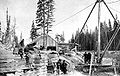 Lock construction at Canal Flats, 1888
 -
 Completed lock at Canal Flats, ca 1889. The timber shown was cut from localponderosa pine.
 -
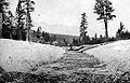 Canal construction, August 1888, possibly the full depth of excavation.
 -
![Plan of Baillie-Grohman Canal and Canal Flats c1922[17]](//upload.wikimedia.org/wikipedia/commons/thumb/5/57/029_Plan_of_Canal_Flats.JPG/120px-029_Plan_of_Canal_Flats.JPG) Plan of Baillie-Grohman Canal and Canal Flats c1922[17]
Plan of Baillie-Grohman Canal and Canal Flats c1922[17] -
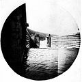
 Remains of the lock c1922.


![Plan of Baillie-Grohman Canal and Canal Flats c1922[17]](/File:029_Plan_of_Canal_Flats.JPG)

See also
Notes
- ^ a b c Downs, Art, Paddlewheels on the Frontier -- The Story of British Columbia and Yukon Sternwheel Steamers, at pages 100-112, Superior Publishing, Seattle, WA 1972
- ISBN 0-8032-5874-7
- ^ Previously referred to as the Wapta River. Lyman, at 277
- ^ a b Lorraine, M.J., Columbia Unveiled, at 439 Times-Mirror Press, Los Angeles CA (1924)
- ^ Wilson, D.M., The History of Creston, BC Virtual Crowsnest Highway (revised 05-04-2008)
- ISBN 1-55002-369-1
- ^ "Welwood, R.J., "Baillie-Grohman's Diversion", 36 British Columbia Historical News, page 2, Fall 2003" (PDF). Archived from the original (PDF) on 2007-07-09. Retrieved 2008-11-30.
- ^ Downing, at 102-103.
- ^ a b Baillie-Grohman, Wm A., Fifteen Years Sport and Life in the Hunting Grounds of Western America and British Columbia, at pages 252-278, Horace Cox, London, 1900
- ^ Freeman, at 69
- ^ a b Freeman, Lewis R., Down the Columbia, at 20-21, 28, 68-70, 140-167, Dixon-Price Publishing, Kingston, WA (reprint of Dodd, Mead 1921 edition) ISBN I-929516-18-5 On-line first edition viewable at American Libraries internet archive here
- ^ a b Virtual Crowsnest Highway (regional history website), "Time Line for Southwestern Canada"
- ^ Other sources state that the entire northbound transit was made on rollers, and Gwendoline was not partially dismantled, but rather had never been fully completed at Hansen's Landing. See Moore, D.M., Riverboating on the Kootenay.
- ISBN 0-87564-220-9
- ISBN 0-87004-221-1
- ^ Another source states that the southbound transit was possible only because of a luckily high level of water in the canal, and mentions nothing about repair. Moore, D.M., Riverboating on the Kootenay
- ^ As drawn by M.J. Lorraine. Roads and railway line shown on this diagram were not present in 1889 when canal was completed.
Further reading
- Kluckner, Michael, Vanishing British Columbia, University of British Columbia Press, Vancouver BC, 2005 ISBN 0-295-98493-7
External links
- Fort Steele Heritage Town, map and diagram page Contains period maps of East Kootenay region, including original maps and later working diagrams of the Baillie-Grohman canal. In particular, this site includes simplified plans drawn by David Morley of the geographic location and the operation of the canal locks which are valuable illustrations of the theory behind the canal.
- Taming the Kootenay, Creston and District Historical and Museum Society Multi-media presentation of history of Canal Flats and the East Kootenay region