
Barrage Vauban
Barrage Vauban | |
|---|---|
 The downstream side of the barrage after restoration in 2012 | |
| Coordinates | 48°34′46″N 7°44′17″E / 48.57944°N 7.73806°E |
| Crosses | River Ill |
| Locale | Strasbourg, France |
| Characteristics | |
| Total length | 120 m (390 ft) |
| History | |
| Opened | 1690 |
| Location | |
 | |
The Barrage Vauban, or Vauban Dam, is a
navigation lock in the modern sense of the word. Today it serves to display sculptures and has a viewing terrace on its roof, with views of the earlier Ponts Couverts bridges and Petite France quarter. It has been classified as a Monument historique since 1971.[1][2][3]
The barrage was constructed from 1686 to 1690 in pink
The barrage has 13 arches and is 120 metres (390 ft) in length. Within the structure an enclosed corridor links the two banks and a lapidarium serves to display ancient plaster casts and copies of statues and gargoyles from Strasbourg Cathedral and Palais Rohan. Three of the arches are raised to permit navigation, and the corridor is carried across these by drawbridges. The roof was rebuilt in 1965-66 in order to construct the panoramic terrace. Admission to the barrage and terrace is free, and they are open daily from 09:00 to 19:30.[3][4][6]
The
École Nationale d'Administration, are both adjacent to the northern end of the barrage. The headquarters (Hôtel du Département) of the Bas-Rhin department is by the southern end.[7]
Gallery
-
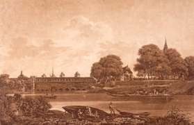 An image of the upstream side of the barrage from 1750
 -
 Upstream side of the barrage showing the stonework
 -
 The internal corridor
 -
 Statues from Palais Rohan in the lapidarium
 -
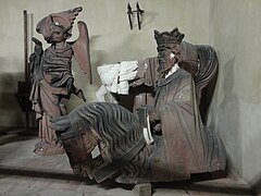 Statues from Strasbourg Cathedral in the lapidarium
 -
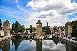 View of part of the Ponts Couverts and Petite France from the terrace


References
- ^ Base Mérimée: Grande écluse de fortification dite barrage Vauban et ses abords fortifiés, Ministère français de la Culture. (in French)
- ^ a b "The Vauban Dam". Office de tourisme de Strasbourg et sa région. Archived from the original on 30 September 2015. Retrieved 30 September 2015.
- ^ a b "Vauban Dam (Barrage Vauban)". Viator, Inc. Archived from the original on 30 September 2015. Retrieved 30 September 2015.
- ^ a b "Barrage Vauban (Strasbourg, 1690)". Structurae (in French). Retrieved 29 September 2015.
- ^ "Neudorf, nouveau village, nouvelle ville" (PDF). Archives.strasbourg.eu (in French). 2007. Archived from the original (PDF) on 22 January 2015. Retrieved 30 September 2015.
- ^ "Barrage Vauban, Strasbourg". Cityzeum SAS. Archived from the original on 30 September 2015. Retrieved 30 September 2015.
- ^ "Barrage Vauban" (Map). Google Maps. Google. Retrieved 1 October 2015.
External links
Wikimedia Commons has media related to Barrage Vauban.
- Barrage Vauban Archived 2015-10-02 at the Wayback Machine on archi-wiki.org (in French)