
Barrhaven
Barrhaven | |
|---|---|
Community | |
Area code 613 |
Barrhaven is a
Geography
Barrhaven is approximately bounded to the north by the
Barrhaven is divided into several areas: Barrhaven proper or Old Barrhaven is the westernmost part of the neighbourhood, lying between
History

The Barrhaven area was long inhabited by First Nations peoples, and the modern Jockvale Road follows an ancient path that was originally a trail through the wilderness. In the 19th century the area became populated by European farmers as the area was divided into a number of rural homesteads.
The old Barrhaven School House located at Jockvale and Strandherd was in built in 1906. Today, the school stands as a historic site. In 1911, the
Modern Barrhaven was established in the 1960s, one of a group of new suburbs built outside the Greenbelt from the main city of Ottawa. Building in the area was begun by Mel Barr, for whom the community is named. Barr had originally purchased a 200-acre (0.81 km2) farm with the intent of constructing a horse racing track. However the Rideau Carleton Raceway was built further to the east, and Barr instead decided to develop his land for housing. In 1968-69 Barrhaven Public School was built as the very first public school in Barrhaven.
Barrhaven was incorporated into the City of Nepean in 1978 and subsequently grew rapidly into a community of several tens of thousands of people. Commercial centres were slower to arrive. In 1990 the area was served by a single grocery store, had no
In 2024, Barrhaven was the site of the city's worst mass killing in its history when six people were killed with a knife-like weapon.[3]
Character

Like most North American suburbs built so quickly and so recently, Barrhaven has a very uniform feel, especially considering how big it is. Almost every street consists of town houses with some streets having comparatively large suburban houses. In the older parts of Barrhaven, the streets are curvilinear, never forming a grid as they do in older parts of Ottawa. The area is very suburban and tends to attract families.
Neighbourhoods
Barrhaven is divided into many neighbourhoods. The names are generally selected by developers.
- Barrhaven (also known as Old Barrhaven) west of Greenbank, south of Fallowfield, north of the rail tracks, and east northeast of Jockvale
- Strandherd Meadows, the infill development extending Old Barrhaven to Strandherd Drive
- Longfields, east of Greenbank Road, west of Woodroffe Avenue, south of Fallowfield Road and north of Strandherd Drive
- Davidson Heights, east of Woodroffe Avenue
- Havenlea, bounded by Crestway Drive, Leikin Drive, Prince of Wales and Cresthaven Drive
- Chapman Mills, bounded by Prince of Wales Dr to the south/east, Woodroffe Ave to the west, and Stoneway Dr to the north.
- Rideau Glen, along Prince of Wales Dr, Holborn Avenue, and Rideau Glen Drive, north of Winding Way
- Winding Way, east of Prince of Wales Drive
- Stonebridge, located between Jockvale Rd and Prince of Wales
- Half Moon Bay, new neighbourhood under development along Cambrian Road, west of Greenbank, east of Highway 416, south of the Jock River and north of Barnsdale Road
- Quinn's Pointe, new community under development along Cambrian Road, west of Greenbank, north of Barnsdale Road[4]
- Barrhaven Mews, new community under construction between Strandherd Road and the Jock River and west of Jockvale/Greenbank Roads
- Barrhaven On The Green, located between Jockvale Road, Greenbank Road, Strandherd Road, and the Rail tracks
- Havenlea, east of Woodroffe Avenue, south of Crestway Drive
- Heart's Desire, located along the Jock River, in between Jockvale Road and Woodroffe Ave.
- West Pointe Village, located between Cedarview Rd., Fallowfield Rd., Strandherd Rd., and the Rail tracks
- Pheasant Run, west of Larkin Drive, south of Fallowfield, north of Jockvale and east of Cedarview Road
- Fraservale, south and west of Jockvale, east of Cedarview and north of rail tracks
- Knollsbrook, west and north of rail tracks, south of Fallowfield and east of Greenbank.
- Havencourt, across from South Nepean Park, east of Greenbank between the transitway and Longfields Drive.
- Havencrest, East of the intersection of Strandherd and Fallowfield and North of Jockvale Road.
Features and amenities
Barrhaven contains several public and
Transportation
Barrhaven is served by seven local
Intercity
Until 2006, it had been planned that the north-south light-rail O-Train (today's Trillium Line) would be extended to the centre of Barrhaven near Riocan Marketplace via Riverside South. The project was cancelled on December 14, 2006, by Ottawa City Council, which decided to focus on building rail-based rapid transit lines in the inner city instead. Rail-based rapid transit to Barrhaven is not expected to be introduced until after 2031, when the three lines in the inner city are expected to be completed.
On January 2, 2007,
In April 2011, the transitway (BRT) network was expanded in Barrhaven. One feature was the extension of Route 94 (now Route 74) to the intersection of Woodroffe and Strandherd. A new stretch of BRT was also constructed between Fallowfield and Strandherd to reduce travel times on Route 95 (Route 75 since 2019).[9] In September 2014, a new BRT route was established on Chapman Mills Drive, using a graveyard median from the canceled south-western LRT route. Route 99 starts at Barrhaven Centre and using new
Education
Public schoolsElementary
IntermediateSecondary |
Catholic schoolsElementary
Secondary
|
Preschools
Private schools
 |
Photos
-
 The welcome sign on Greenbank road entering Barrhaven
 -
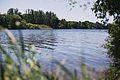 The Rideau river south of Barrhaven
 -
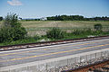 The railroad and experimental farm on the north side of Barrhaven
 -
 Berry Glen Park in East Barrhaven


Notes
- ^ Population calculated by combining census tracts 5050140.03, 5050140.05, 5050140.04, 5050140.07, 5050140.06, 5050141.11, 5050141.10, 5050141.16, 5050141.17, 5050141.09, 5050141.18, 5050141.19, 5050141.20, 5050141.21, 5050141.22, 5050141.13, 5050141.04, 5050141.23, 5050141.24, 5050141.25, 5050141.26
- ^ Desmond Kennedy. "Coming of the Rail Era" Archived 2011-07-23 at the Wayback Machine The Kennedy Story (transcribed by Taylor Kennedy) Accessed July 3, 2007.
- ^ "Ottawa's worst mass killing shocks and devastates Barrhaven, and the city". Ottawa Citizen. March 7, 2024. Retrieved March 7, 2024.
- ^ "Minto launches Quinn's Pointe in Barrhaven". Retrieved 2015-10-05.
- ^ "Small business week: Entrepreneurs take over Barrhaven condos - Special Reports - Ottawa Business Journal". www.obj.ca. Archived from the original on 2016-03-04. Retrieved 2015-10-05.
- ^ "Minto Recreation Complex - Barrhaven". ottawa.ca. Archived from the original on 1 December 2020. Retrieved 2015-10-06.
- ^ "Photos: Residents, VIPs turn out for opening of Barrhaven's Minto Recreation Complex". Ottawa Citizen. 29 November 2014. Archived from the original on 10 February 2018. Retrieved 28 April 2021.
- ^ "CitiGate - 416 Corporate Campus | regionalgroup.com". regionalgroup.com. Archived from the original on 2016-06-11. Retrieved 2016-05-17.
- ^ http://www.octranspo.com/community-events/barrhaven_transplan[permanent dead link]
References
- Melanie O'Brien. "Thriving beyond the greenbelt: Barrhaven growing rapidly as buyers look for a sense of community." The Ottawa Citizen. Jun 29, 1996. p. J.1
- Janet Collins. "The Far Haven: Barrhaven" The Ottawa Citizen. Feb 1, 1993. p. B.3
- Carrie Buchanan. "A sleeping suburb; Barrhaven's nothing but a bedroom community." The Ottawa Citizen. Oct 29, 1989. p. D.1
| History |
|
|---|---|
| Geography | |
| Culture |
|
| Public services | |
| Education | |
| Government | |
| Transportation and infrastructure | |
| Features | |