
Beclabito, New Mexico
Beclabito, New Mexico | ||
|---|---|---|
FIPS code 35-06425 | | |
| GNIS feature ID | 2407820[2] | |
Beclabito (
Description
The CDP is on the
Geography
According to the United States Census Bureau, the CDP has a total area of 7.5 square miles (19 km2), all land.[4]
Demographics
| Census | Pop. | Note | %± |
|---|---|---|---|
| 2020 | 265 | — | |
| U.S. Decennial Census[7][3] | |||
| Languages (2000) [8] | Percent |
|---|---|
| Spoke Navajo at home | 80.00% |
| Spoke English at home | 20.00% |
As of the
There were 95 households, out of which 42.1% had children under the age of 18 living with them, 48.4% were married couples living together, 27.4% had a female householder with no husband present, and 21.1% were non-families. 20.0% of all households were made up of individuals, and 9.5% had someone living alone who was 65 years of age or older. The average household size was 3.57 and the average family size was 4.19.
In the CDP, the population was spread out, with 34.5% under the age of 18, 9.1% from 18 to 24, 29.5% from 25 to 44, 17.7% from 45 to 64, and 9.1% who were 65 years of age or older. The median age was 31 years. For every 100 females, there were 88.3 males. For every 100 females age 18 and over, there were 83.5 males.
The median income for a household in the CDP was $14,766, and the median income for a family was $18,839. Males had a median income of $16,063 versus $24,688 for females. The
- Although 2000 US Census only recorded 339 people in the Beclabito area, there are 900 voting members registered at the Beclabito Chapture House, which is a part of the Navajo Nation, and 1500 individuals living in Beclabito and the surrounding area.[10]
Education
Central Consolidated Schools serves Beclabito as well as other communities in western San Juan County.
-
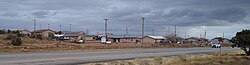 Houses in Beclabito
 -
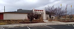 Beclabito Chapter House


See also
References
- ^ "ArcGIS REST Services Directory". United States Census Bureau. Retrieved October 12, 2022.
- ^ a b U.S. Geological Survey Geographic Names Information System: Beclabito, New Mexico
- ^ a b "Census Population API". United States Census Bureau. Retrieved October 12, 2022.
- ^ U.S. Census Bureau. Retrieved October 20, 2017.
- ^ Trail of the Ancients. Archived 2014-08-21 at the Wayback Machine New Mexico Tourism Department. Retrieved August 14, 2014.
- ISBN 0826316891.
- ^ "Census of Population and Housing". Census.gov. Retrieved June 4, 2016.
- ^ "Data Center Results". March 8, 2016. Archived from the original on March 8, 2016. Retrieved December 8, 2020.
- ^ "U.S. Census website". United States Census Bureau. Retrieved January 31, 2008.
- ^ Beclabito Chapter House, August 2015
External links
![]() Media related to Beclabito, New Mexico at Wikimedia Commons
Media related to Beclabito, New Mexico at Wikimedia Commons
Municipalities and communities of San Juan County, New Mexico, United States | ||
|---|---|---|
| Cities |  | |
| CDPs |
| |
| Other communities | ||
| Indian reservations | ||
| Footnotes | ‡This populated place also has portions in an adjacent county or counties | |
| ||
| Tónaneezdizí (Western Agency) |
|
|---|---|
| Chʼínílį́ (Chinle Agency) | |
| Tséhootsooí (Fort Defiance Agency) | |
| Naatʼáaniinééz (Shiprock Agency) | |
| Tʼiistsʼózí (Eastern Agency) | |