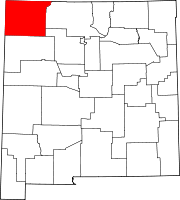
La Plata, New Mexico
Appearance
La Plata, New Mexico | ||
|---|---|---|
Census-designated place | ||
ZIP code 87418 | ||
| Area code | 505 | |
| GNIS feature ID | 890851[3] | |
La Plata is a
.Demographics
| Census | Pop. | Note | %± |
|---|---|---|---|
| 2020 | 2,105 | — | |
| U.S. Decennial Census[7][2] | |||
Education
Its school district is Farmington Municipal Schools.[8]
References
- ^ "ArcGIS REST Services Directory". United States Census Bureau. Retrieved October 12, 2022.
- ^ a b "Census Population API". United States Census Bureau. Retrieved October 12, 2022.
- ^ "La Plata". Geographic Names Information System. United States Geological Survey, United States Department of the Interior.
- ^ "U.S. Census website". United States Census Bureau. Retrieved May 14, 2011.
- ^ United States Postal Service (2012). "USPS - Look Up a ZIP Code". Retrieved February 15, 2012.
- ^ "Postmaster Finder - Post Offices by ZIP Code". United States Postal Service. Archived from the original on October 17, 2020. Retrieved October 24, 2013.
- ^ "Census of Population and Housing". Census.gov. Retrieved June 4, 2016.
- U.S. Census Bureau. Retrieved July 12, 2022.

