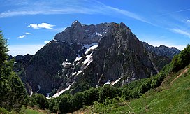
Bellunes Alps
| Bellunes Alps | |
|---|---|
 Col Nudo, the highest peak in the Bellunes Alps | |
| Highest point | |
| Peak | Col Nudo |
| Elevation | 2,472 m s.l.m. |
| Geography | |
| State | |
| Range coordinates | 46°10′19″N 12°07′00″E / 46.172075°N 12.1166871°E |
| Parent range | Eastern Alps |
The Bellunes Alps (German: Belluneser Alpen, Italian: Prealpi Bellunesi) is the now obsolete name of a mountain range on the southern edge of the Eastern Alps.
They lie in the
Trentino-South Tyrol. They cover the provinces of Treviso, Pordenone and part of Vicenza. The name is derived from the town of Belluno. Their highest peak is Col Nudo
at 2,472 m s.l.m..
They are part of the
main dolomite
.
The Bellunes Alps used to be an independent group in the
Monte Schiara
(2,565 m s.l.m.).
In 1990, the northern, dolomitic part was declare a national park: the Bellunes Dolomites National Park.
External links
Wikimedia Commons has media related to Bellunes Alps.
- Bellunes Dolomites National Park Archived 2009-01-31 at the Wayback Machine - information on the northern part of the Bellunes Alps

