
Benlettery
| Benlettery | |
|---|---|
| Binn Leitrí | |
 Benlettery behind the Ballynahinch Castle fishery | |
| Highest point | |
| Elevation | 577 m (1,893 ft)[1] |
| Prominence | 62 m (203 ft)[1] |
| Listing | Arderin |
| Coordinates | 53°28′55″N 9°50′43″W / 53.481824°N 9.845263°W[1] |
| Naming | |
| English translation | Peak of the Wet Hillsides |
| Language of name | Irish |
| Geography | |
 Benlettery Ireland | |
| Location | County Galway, Ireland |
| Parent range | Twelve Bens |
| OSI/OSNI grid | L7754649537 |
| Topo map | OSi Discovery 44 |
| Geology | |
| Type of rock | Pale quartzites, grits, graphitic bedrock[1] |
Benlettery (
Naming
According to Irish academic Paul Tempan, the
Geography
Benlettery is the southernmost peak of the Twelve Bens and lies at its western edge. Benlettery is connected to the range by a high northerly ridge to the peak of Bengower 664 metres (2,178 ft);[5] this ridge forms a fork which also connects neighboring Benglenisky 516 metres (1,693 ft) to Bengower.[5][9] Benlettery is one of the six Bens that form a horseshoe around the valley of the Glencoaghan River (also known as the Glencoaghan Horseshoe).[10][11]
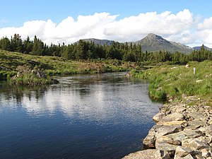
Unlike most of the other main Bens, Benlettery is below 600-metres in elevation, however, its relative positioning at the southern end of the range, and its "pyramidal" summit (when viewed from the south), means that is often featured as a scenic backdrop to the Ballynahinch Castle and the Ballynahinch Lake.[12]
Ben Lettery Connemara Youth Hostel
On the southern slopes of Benlettery is the 40-bed "Ben Lettery Connemara Youth Hostel" (Benlettery spelt as two words), owned and operated by
Hill walking
As with
Benlettery is part of the 16–kilometre 8–9 hour Glencoaghan Horseshoe, considered one of Ireland's best hill-walks;[10][11] and of the even longer Owenglin Horseshoe, a 20–kilometre 10–12 hour route around the Owenglin River taking in over twelve summits.[9]
Gallery
-
 Benlettery behind Ballynahinch Castle
 -

-
 Benlettery (right) and Benglenisky (left), from the Owenmore River
 -
 Benlettery (left) and Benglenisky (right) from summit of Bengower
.jpg)


_and_Benglenisky_(right)_from_Bengower.jpg)
Bibliography
- Fairbairn, Helen (2014). Ireland's Best Walks: A Walking Guide. Collins Press. ISBN 978-1848892118.
- ISBN 978-1-84889-164-7.
- Paul Phelan (2011). Connemara & Mayo - A Walking Guide: Mountain, Coastal & Island Walks. Collins Press. ISBN 978-1848891029.
- Dillion, Paddy (2001). Connemara: Collins Rambler's guide. Harper Collins. ISBN 978-0002201216.
- Dillion, Paddy (1993). The Mountains of Ireland: A Guide to Walking the Summits. Cicerone. ISBN 978-1852841102.
See also
- Twelve Bens
- Mweelrea, major range in Killary Harbour
- Maumturks, major range in Connemara
- Lists of mountains in Ireland
- Lists of mountains and hills in the British Isles
References
- ^ MountainViews Online Database. Retrieved 31 July 2019.
- ^ a b c d Paul Tempan (February 2012). "Irish Hill and Mountain Names" (PDF). MountainViews.ie.
- MountainViews Online Database.
- MountainViews Online Database.
- ^ ISBN 978-1-84889-164-7
- ISBN 978-0002201216.
- ^ An Oige, Irish Youth Hostel Association. Retrieved 9 August 2019.
- ^ a b "Ben Lettery Hostel". Lonely Planet. Retrieved 9 August 2019.
- ^ ISBN 978-0002201216.
Walk 24: Owenglin Horseshoe
- ^ ISBN 978-1848892118.
ROUTE 34: The Glencoaghan Horseshoe. A true classic
- ^ ISBN 978-0002201216.
Walk 30: Gleann Chóchan Horseshoe
- ^ ISBN 978-0002201216.
Walk 23: Binn Ghleann Uisce
- ^ "10 Awesome An Óige Hostels". Outside.ie. Retrieved 9 August 2019.
- Irish Times. Retrieved 9 August 2019.
- ISBN 978-1848891029.
Route 4: Benglenisky, Bengower and Benlettery
External links
- MountainViews: The Irish Mountain Website, Benlettery
- MountainViews: Irish Online Mountain Database
- The Database of British and Irish Hills , the largest database of British Isles mountains ("DoBIH")
- Hill Bagging UK & Ireland, the searchable interface for the DoBIH
| British Isles |  | |
|---|---|---|
| Scotland | ||
| Outside Scotland | ||
| England | ||
| Ireland | ||
| County tops | ||
| Achill Island |  | ||||||
|---|---|---|---|---|---|---|---|
| Dartry Mountains | |||||||
| Maumturks | |||||||
Mweelrea Mountains | |||||||
| Nephin Range | |||||||
| Ox Mountains | |||||||
| Partry Mountains | |||||||
| Sheeffry Range | |||||||
| Benna Beola |
| ||||||
| Others | |||||||
.jpg)
