
Beremiany, Ternopil Oblast
Beremiany
Берем'яни | |
|---|---|
| Coordinates: 48°53′11″N 25°26′51″E / 48.88639°N 25.44750°E | |
| Country | UTC+3 (EEST) |
| Postal code | 48464 |
| Area code | +380 3544 |
Beremiany (Ukrainian: Берем'яни) is a village in Chortkiv Raion (district) of Ternopil Oblast (province) in western Ukraine. It belongs to Buchach urban hromada, one of the hromadas of Ukraine.[1]
Until 18 July 2020, Beremiany belonged to Buchach Raion. The raion was abolished in July 2020 as part of the administrative reform of Ukraine, which reduced the number of raions of Ternopil Oblast to three. The area of Buchach Raion was merged into Chortkiv Raion.[2][3]
Notable people
- Kornel Ujejski, Polish poet and political writer.
Gallery
-
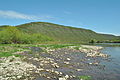
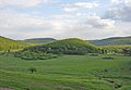 Mountain Velyka Govda
 -
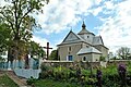 Saint Nicolas church
 -
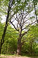 Natural heritage site "Beremiany Quercus"
 -
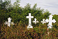 Cultural heritage monument of history "Ukrainian-Polish Cemetery"
 -
 Dniester Canyon near Beremiany


References
- ^ "Бучацька міська громада" (in Ukrainian). Портал об'єднаних громад України.
- ^ "Про утворення та ліквідацію районів. Постанова Верховної Ради України № 807-ІХ". Голос України (in Ukrainian). 2020-07-18. Retrieved 2020-10-03.
- ^ "Нові райони: карти + склад" (in Ukrainian). Міністерство розвитку громад та територій України.
External links
- "Beremiany z GłębokaGłęboką". Geographical Dictionary of the Kingdom of Poland (in Polish). 1. Warszawa: Kasa im. Józefa Mianowskiego. 1880. p. 139.
Wikimedia Commons has media related to Beremiany, Ternopil Oblast.
This article about a location in Ternopil Oblast is a stub. You can help Wikipedia by expanding it. |