
Beresford Square
Woolwich Arsenal | |
| Coordinates | 51°29′28″N 0°04′09″E / 51.491111°N 0.069167°E |
|---|---|
| Construction | |
| Inauguration | 1813 |
| Other | |
| Known for | Woolwich Market Royal Arsenal Gatehouse |
Beresford Square is a pedestrianised town and market square in Woolwich in the Royal Borough of Greenwich in London, England. It was formed in the early 19th century and was named after the Anglo-Irish general William Beresford, Master-General of the Ordnance and Governor of the Royal Military Academy in Woolwich. With its lively street market and lined with shops, pubs and restaurants, Beresford Square has been the heart of Woolwich for over two centuries. Since 2019 the square is part of a conservation area.
Location
Beresford Square is situated in central Woolwich, between the town's shopping district and the Royal Arsenal, from which it is separated by the busy A206 road. The western section of this road is called Beresford Street, the eastern section Plumstead Road. The square is largely pedestrianised. To the east lies Woolwich New Road, accessible only for busses. Most of the bus stops are on Woolwich New Road or General Gordon Square, around Woolwich Arsenal station. Beresford square is situated close to the railway and DLR stations, as well as the future Crossrail station, more or less in between the four station buildings.
History
19th century
Beresford Square is not a laid-out square but the result of a series of clearances. Therefore, some of the buildings are older than the square. In 1812–13, some "paltry buildings" around the road junction near the main entrance to the Arsenal were demolished for "encroachment on Crown land". The northern section of the road that wound down from

The clearance formed a spacious entrance to the Royal Arsenal and in 1828-29 a new entrance gate was built by the
Woolwich Market received its charter in 1618 but may have existed before. In 1808 it moved from Market Hill (near Woolwich High Street) to Market Street (in the Bathway Quarter). This peripheral location proved to be unpopular with traders, who drifted back to Market Hill and, after 1813, to the new square in front of the Arsenal (where no market tolls had to be paid). The police regularly cleared the square and it was not until 1879 that the existing situation was accepted and regulated. In 1887 the Local Board of Health bought out the Maryon Wilson family's interest in the market charter. A new market was laid out by the Board with room for 136 stalls, against much opposition from costermongers. It officially opened in September 1888. In the middle of the square stood an iron toll house, a drinking fountain and a brightly ornamental urinal. Most of the pubs and shops around the square were rebuilt in the last two decades of the 19th century.[4]
20th and 21st century
Throughout the 20th century, Beresford Square remained the centre of Woolwich life. In 1907 some 8,000 Arsenal workers sett off from here to demonstrate in Westminster against job cuts. Trade unionist and Labour politician Will Crooks spoke several times to large crowds in front of the Arsenal gate. Crook's memorial service was held on the square in June 1921.

The market was thriving six days a week and drew in shoppers from neighbouring areas.[5] As the market was often overcrowded, plans for extension were made in 1901 but only realized in 1936 with the opening of the covered market on Plumstead Road. Traffic congestion continued to be a major problem with trams and other traffic running through the square. In 1958, 1969 and 1972 plans were presented for the widening of both Beresford Street and Plumstead Road, and the pedestrianisation of the square. Initially, Beresford Gate was to be demolished in the plans approved by the Greater London Council. In 1984-86 the A206 road was rerouted through the Arsenal, north of the gate. In the early 1990s and yet again in 2010–11, Greenwich Council relandscaped the square. A portal reflecting the market's history was erected at its Woolwich New Road entrance. By that time the market's popularity had declined considerably, parallel to the town's general decline after the closure of the Arsenal. With the redevelopment of the Arsenal it is hoped that the market will be reinvigorated.[6][7][8]
In 1913, the Woolwich Arsenal Cinematograph Co. started a cinema in a building between the Salutation pub and Holy Trinity Church. Twelve years later it was extended to the rear, replacing much of the north side of Salutation Alley, creating a theater with 669 seats. It was later renamed Premier Cinema, Royal Arsenal Cinema and Century Cinema. It closed in 1964 and was demolished shortly afterwards, along with Holy Trinity, the Salutations Inn and other neighbouring buildings.[9]
In May 2019 the square became part of a conservation area. The Woolwich Conservation Area comprises Greens End, General Gordon Square, parts of Woolwich New Road, the Bathway Quarter, Powis Street, Hare Street, Mortgramit Square, parts of Woolwich High Street (south) and St Mary's Church and Gardens.[10]
-
 Green's End, now central Woolwich, c. 1790
 -
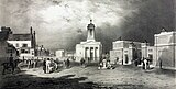 The new square, c. 1835
 -
 The High Pavement in 1868
 -
 The square in the early 20th century


Description
Northwest side
The
The row of buildings at what was once called the High Pavement are modern (Newman, Levinson & Partners, 1969–70), except for a modest late-19th-century survivor in the middle (nr. 5; Chessum & Sons, 1892–93). The public lavatories, underground since 1913, were rebuilt above-ground in the early 1990s. In front of the plain brick building stands another cattle drinking trough, this one from 1904. [12]
-
 Northwest section before pedestrianisation, 1974
 -
 View towards Plumstead Road
 -
 Royal Arsenal Gatehouse
 -
 Lavatories and cattle trough, 1904


Southeast side
The east side consists of an imposing block of late-Victorian, Italianate buildings, including the Ordnance Arms public house and three shops, all with frontages on the market square and the New Road (J. Chapman, 1888). An ogee-domed turret on one end of the block matches an octagonal one on the other corner. The pub featured a first-floor club room, now a church hall. After being renamed O'Connors for a while, the pub retook its original name in 2015. The market gate of the early 1990s consists of a two-sided metal portal. The brightly coloured decorations refer to the long history of Woolwich Market.[13]
Since 1935, the back of Equitable House, the former head office of the Woolwich Equitable Building Society, looms over the smaller buildings on the south side of Beresford Square. Two houses that probably date from the early 1780s, 18-19 Green's End, are the oldest in the square. Both houses have been altered and have forward extensions for commercial use, which makes it difficult to appreciate them. They were admired by John Betjeman in 1965. No. 18 became the Elephant & Castle public house in 1848, deriving its name from a famous inn in South London. The present-day pub extension dates from the late 1950s and includes the premises next-door, 10 Beresford Square. All other buildings on this side date from the 1880s. Adjacent to no. 19 is now a vacant lot next to the new station for the Docklands Light Railway, that was built here in 2005–09.[14]
-
 View from Woolwich New Road towards the Ordnance Arms pub
 -
 Woolwich New Road entrance with Victorian buildings and market portal
 -
 Market stalls and Elephant & Castle pub; behind the pub Green's End No. 18
 -
 Former High Pavement; view towards Equitable House


Pedestrianisation
Starting in 2009 and ending in Spring 2012, Beresford Square, along with the neighbouring Greens End and General Gordon Square, was redeveloped to be more centred on pedestrians. Bus stops were also relocated on Beresford Street and Thomas Street. Since 2019, buses cannot turn right from Beresford Street on to Plumstead Road, as a result of a separate redevelopment scheme on Plumstead Road, including the brief use of the former Woolwich Public Market as Public, a street-food market owned by the former company Street Feast, who also opened markets in Canary Wharf, Canada Water, Lewisham and Shoreditch.
References
Sources
- Bedford, K., Woolwich through time, Amberley Publishing, 2014. ISBN 978 1 4456 1599 8
- Greenwich Council, Woolwich Town Centre Masterplan Supplementary Planning Document, 2012 (PDF online available on royalgreenwich.gov.uk)
- Saint, A., Guillery, P. (ed.), Woolwich – Survey of London, Volume 48, Yale Books, London, 2012. ISBN 978 0 300 18722 9
Citations; references
- ^ "Very poor and rough, Irish, some costers, some thieves, fat loathsome women, barrows". Saint & Guillery (2012), p. 228
- ^ Saint & Guillery (2012), pp. 5, 224-226, 228.
- ^ Saint & Guillery (2012), pp. 79-80, 162-163, 225-226
- ^ Saint & Guillery (2012), pp. 226, 228, 230
- ^ In 1900, The Royal Magazine published a seven-page article entitled 'The Street Auctions of Military Woolwich' in its American edition. Bedford (2014), p. 40
- ^ Saint & Guillery (2012), p. 227
- ^ Woolwich Town Centre Masterplan SPD (2012), pp. 16, 62, 68, 80
- ^ Bedford (2014), p. 42
- ^ Saint & Guillery (2012), pp. 228-230
- ^ Woolwich Conservation Area Character Appraisal SPD, Draft June 2021, page 2, 4.
- ^ Saint & Guillery (2012), pp. 162-163, 225-227
- ^ Saint & Guillery (2012), pp. 225-228
- ^ Saint & Guillery (2012), pp. 227, 230
- ^ Saint & Guillery (2012), pp. 229-230
External links
- Beresford Square Market on royalgreenwich.gov.uk
- Beresford square and Beresford street - photos on chrismansfieldphotos.com