
Bhemwa
Bhemwa | |
|---|---|
Village | |
Sabang | |
| Website | paschimmedinipur |
Bhemwa (also written as Bhemua) is a village and a
Geography


5miles
CT: census town, R: rural/ urban centre, H: historical/ religious centre
Owing to space constraints in the small map, the actual locations in a larger map may vary slightly
Location
Bhemwa is located at 22°13′24″N 87°40′58″E / 22.2232°N 87.6828°E.
Area overview
Kharagpur subdivision, shown partly in the map alongside, mostly has alluvial soils, except in two CD blocks in the west – Kharagpur I and Keshiary, which mostly have lateritic soils. Around 74% of the total cultivated area is cropped more than once.[1] With a density of population of 787 per km2nearly half of the district's population resides in this subdivision. 14.33% of the population lives in urban areas and 86.67% lives in the rural areas.[2]
Note: The map alongside presents some of the notable locations in the subdivision. All places marked in the map are linked in the larger full screen map.
Demographics
According to the
.*For language details see Sabang (community development block)#Language and religion
Education
Bhemwa A.B. High School is a Bengali-medium co-educational institution established in 1957. It has facilities for teaching from class V to class XII. It has a library with 2,600 books, 9 computers and a playground.[4]
Bhemwa R.T. Girls School is a Bengali-medium girls only institution established in 1966. It has facilities for teaching from class V to class X. It has a library with 325 books and a playground.[5] Girls
Bhemwa picture gallery
-
 Naba-ratna Sitaram temple of Bhattacharya family
 -
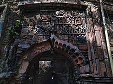 Terracotta relief in Sitaram temple


References
- ^ "District Human Development Report Paschim Medinipur, 2011". page 27-28. Department of Planning and Statistics, Government of West Bengal. Retrieved 10 September 2020.
- ^ "District Statistical Handbook Paschim Medinipur, 2013". Table 2.2, 2.4 (a). Department of Planning and Statistics. Retrieved 10 September 2020.
- ^ "CD block Wise Primary Census Abstract Data(PCA)". West Bengal – District-wise CD blocks. Registrar General and Census, India. Retrieved 19 August 2020.
- ^ "Bhemwa AB High School U Pry". Schools.org. Retrieved 19 August 2020.
- ^ "Bhemwa R.T. Girls School U. Pry". Schools.org. Retrieved 19 August 2020.
External links
| ||||||||
|---|---|---|---|---|---|---|---|---|
| Cities, municipal and census towns |
|  | ||||||
| Locations other than cities and towns | ||||||||
| Related topics | ||||||||
This article about a location in the Paschim Medinipur district of West Bengal is a stub. You can help Wikipedia by expanding it. |