
Dubrajpur, Paschim Medinipur
Dubrajpur | |
|---|---|
Village | |
Sabang | |
| Website | paschimmedinipur |
Dubrajpur is a village in the
Geography


5miles
CT: census town, R: rural/ urban centre, H: historical/ religious centre
Owing to space constraints in the small map, the actual locations in a larger map may vary slightly
Location
Dubrajpur is located at 22°11′29″N 87°43′29″E / 22.1915°N 87.7246°E.
Area overview
Kharagpur subdivision, shown partly in the map alongside, mostly has alluvial soils, except in two CD blocks in the west – Kharagpur I and Keshiary, which mostly have lateritic soils. Around 74% of the total cultivated area is cropped more than once.[1] With a density of population of 787 per km2nearly half of the district's population resides in this subdivision. 14.33% of the population lives in urban areas and 86.67% lives in the rural areas.[2]
Note: The map alongside presents some of the notable locations in the subdivision. All places marked in the map are linked in the larger full screen map.
Demographics
According to the
Culture
David J. McCutchion mentions the early 19th century Lakshmi Janardana temple as a rich terracotta West Bengal Nava-ratna with ridged turrets measuring 21’ 2" square.[4]
Dubrajpur picture gallery
-
 Lakshmi Janardana temple
 -
 Lakshmi Janardana temple
 -
 Terracotta panels
 -
 Terracotta panels
 -
 Terracotta panels
 -
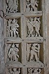 Cavings on wooden door


References
- ^ "District Human Development Report Paschim Medinipur, 2011". page 27-28. Department of Planning and Statistics, Government of West Bengal. Retrieved 10 September 2020.
- ^ "District Statistical Handbook Paschim Medinipur, 2013". Table 2.2, 2.4 (a). Department of Planning and Statistics. Retrieved 10 September 2020.
- ^ "CD block Wise Primary Census Abstract Data(PCA)". West Bengal – District-wise CD blocks. Registrar General and Census, India. Retrieved 19 August 2020.
- ISBN 978-93-81574-65-2
External links
| ||||||||
|---|---|---|---|---|---|---|---|---|
| Cities, municipal and census towns |
|  | ||||||
| Locations other than cities and towns | ||||||||
| Related topics | ||||||||
This article about a location in the Paschim Medinipur district of West Bengal is a stub. You can help Wikipedia by expanding it. |