
Ramjibanpur
Ramjibanpur | |
|---|---|
City | |
Chandrakona | |
| Website | ramjibonpurmuniciality |
Ramjibanpur is a city and a municipality in the
Geography


5miles
M: municipal city/ town, R: rural/ urban centre, H: historical/ religious centre
Owing to space constraints in the small map, the actual locations in a larger map may vary slightly
Location
Ramjibanpur is located at 22°50′N 87°37′E / 22.83°N 87.62°E,[1] at an average elevation of 11 metres (36 feet).
Area overview
Ishwar Chandra Vidyasagar, scholar, social reformer and a key figure of the Bengal Renaissance, was born at Birsingha on 26 September 1820.[2][3]
Ghatal subdivision, shown in the map alongside, has alluvial soils. Around 85% of the total cultivated area is cropped more than once.[4] It has a density of population of 1,099 per km2, but being a small subdivision only a little over a fifth of the people in the district reside in this subdivision. 14.33% of the population lives in urban areas and the rest in the rural areas.[5]
Note: The map alongside presents some of the notable locations in the subdivision. All places marked in the map are linked in the larger full screen map.
Demographics
As per
As of 2001[update] India census,[7] Ramjibanpur had a population of 17,363. Males constitute 51% of the population and females 49%. Ramjibanpur has an average literacy rate of 72%, higher than the national average of 59.5%: male literacy is 78%, and female literacy is 66%. In Ramjibanpur, 14% of the population is under 6 years of age.
Culture
David J. McCutchion mentions:[8]
- The Vishnu temple in Dayalbazar as a small flat roofed or chandni type, with terracotta decoration, built in 1833, measuring 14’ square’
- The Radhakanta temple in Natunhat, in the same category as the Vishnu temple, with terracotta decoration, built in 1829, measuring 14’ 10” x 15’.
- The Sridhara and Shiva temples (two attached temples), in the same category as the Vishnu temple, with extended façade for extra chambers, plain, measuring 24’ 3” x 3’.
- a pancha-ratna temple with ridged rekha turrets and porch on triple archway, of the standard West Bengal type with facades fully decorated.
- a pancha-ratna with ridged rekha turrets and single entrance with figures above the archway and around the façade.
- a West Bengal nava-ratna, with terracotta decoration, now fallen to ruin.
Ramjibanpur picture gallery
-
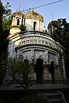 Damodar temple of Piri family
 -
 Damodar temple
 -
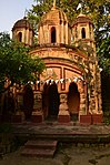 Sridharlaljiu temple of Piri family
 -
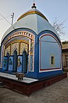 Buro Shiva temple, possibly built in 1866
 -
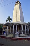 Parbatinath temple: the old temple built in 1801-02 collapsed and this new temple was built


References
- ^ Falling Rain Genomics, Inc - Ramjibanpur
- ^ Murshid, Ghulam. "Vidyasagar, Pundit Iswar Chandra". Banglapedia. Retrieved 24 July 2016.
- ^ "Ishwar Chandra Vidyasagar". www.whereincity.com. Retrieved 24 July 2016.
- ^ "District Human Development Report Paschim Medinipur, 2011". page 27-28. Department of Planning and Statistics, Government of West Bengal. Retrieved 10 September 2020.
- ^ "District Statistical Handbook Paschim Medinipur, 2013". Table 2.2, 2.4 (a). Department of Planning and Statistics. Retrieved 10 September 2020.
- ^ "2011 Census – Primary Census Abstract Data Tables". West Bengal – District-wise. Registrar General and Census Commissioner, India. Retrieved 28 August 2020.
- ^ "Census of India 2001: Data from the 2001 Census, including cities, villages and towns (Provisional)". Census Commission of India. Archived from the original on 16 June 2004. Retrieved 1 November 2008.
- ISBN 978-93-81574-65-2
External links
| ||||||||
|---|---|---|---|---|---|---|---|---|
| Cities, municipal and census towns |
|  | ||||||
| Locations other than cities and towns | ||||||||
| Related topics | ||||||||