
Boulder Park
Boulder Park National Natural Landmark, of Douglas County, Washington, along with the nearby McNeil Canyon Haystack Rocks and Sims Corner Eskers and Kames natural landmarks, illustrate well-preserved examples of classic Pleistocene ice stagnation landforms that are found in Washington. These landforms include numerous glacial erratics and haystack rocks that occur near and on the Withrow Moraine, which is the terminal moraine of the Okanogan ice lobe.[1][2]
Geomorphology
Boulder Park is located on the Waterville Plateau of the
This park lies about 6 kilometers (3.7 mi) northeast and 17 kilometers (11 mi) north of the arcuate ridge of the Withrow Moraine. It marks the southern, 17,000 year-old
The
Underlying the glacial deposits of the Okanogan ice lobe and outcropping, where it is absent, is the middle
See also
- List of National Natural Landmarks in Washington State
References
- ^ ISBN 0-89301-206-8.
- ^ ISBN 978-1879628397
- ^ a b Gulick, C.W., and M.A. Korosec (1990) Geologic map of the Banks Lake 1:100,000 quadrangle, Washington. Open File Report 90-6. Seattle, Washington, Washington Division of Geology and Earth Resources. 20 p., 1 pl.
- ^ a b Easterbrook, D.J. (2003) Cordilleran Ice Sheet Glaciation of the Puget Lowland and Columbia Plateau, and alpine glaciation of the North Cascade Range. in Swanson, T.W., ed., Western Cordillera and Adjacent Areas. Field Guide 4, Boulder, Colorado, Geological Society of America. p. 137-157
- ^ Cheney, E.S. (2009) Floods, Flows, Faults, Glaciers, Gold and Gneisses, From Quincy to Chelan to Wenatchee, June 13–14, 2009. Society Field Trips in Pacific Northwest Geology Field Trip Guidebook 24. Seattle, Washington, Northwest Geological Society. 44 p.
External links
Photo gallery
-
-
 A kame among the glacial drift on the terminal moraine.
 -
 Terminal moraine (Withrow Moraine) of the Okanagon Lobe
 -
 Multiple erratics on the terminal moraine of the Okanagon Lobe. Cascade mountains in the background.
 -
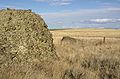
 Multiple erratics on the terminal moraine of the Okanagon Lobe.


| Ice Age Glacial Floods |
|  |
|---|---|---|
| Glacial Lakes | ||
| Temporary Lakes | ||
| Ice Age Floods Glacial Residue | ||
| Ice Age Floods Erosion & Deposition Features | ||
| Related contemporaneous events |
| |