
Withrow Moraine and Jameson Lake Drumlin Field
| Withrow Moraine and Jameson Lake Drumlin Field | |
|---|---|
Washington state | |
| Coordinates | 47°41′15″N 119°37′29″W / 47.68750°N 119.62472°W |
| Designated | 1986 |
The Withrow Moraine and Jameson Lake Drumlin Field is a
Geologic history

The plateau
The Withrow Moraine and Jameson Lake Drumlin Field National Natural Landmark is located on the Waterville Plateau, which lies in the northwest corner of the
The glacial history

Two million years ago the
Progress of the Okanogan Lobe of the Cordilleran Glacier

The Okanogan lobe of the
After the glacier
As the Okanogan lobe melted, the northern half of the Waterville Plateau, including the upper portions of Moses Coulee, were littered with clear evidence of its passing. The glacier left behind a blanket of glacial till, up to 50 feet thick in places. This glacial till, composed of clay, silt, sand, gravel, cobblestones, and erratic boulders, covers most of the upper Moses Coulee. The melting glacier discharged both down Moses Coulee and into the Grand Coulee as is evident in the Sims Corner eskers and kames.[8]
See also
- List of National Natural Landmarks
- Terminal moraine
- List of glacial moraines
References
- ^ "Withrow Moraine and Jameson Lake Drumlin Field". nps.gov. National Park Service.
- ^ ISBN 0-87842-415-6.
- ^ ISBN 978-1-879628-27-4.
- works of the United States Government, which are in the public domain
- ISBN 0-87842-323-0.
- ^ Carson, Robert J.; Pogue, Kevin R. (1996). Flood Basalts and Glacier Floods:Roadside Geology of Parts of Walla Walla, Franklin, and Columbia Counties, Washington. Washington State Department of Natural Resources (Washington Division of Geology and Earth Resources Information Circular 90).
- ^ ISBN 0-89301-206-8.
- ^ Washington history link.
External links
Photo gallery
-
-
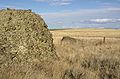
 A kame among the glacial drift on the terminal moraine.
 -
 Terminal moraine of the Okanagon Lobe
 -
 Multiple erratics on the terminal moraine of the Okanogan Lobe. Cascade mountains in the background.
 -
 Multiple erratics on the terminal moraine of the Okanogan Lobe.


| Ice Age Glacial Floods |
|  |
|---|---|---|
| Glacial Lakes | ||
| Temporary Lakes | ||
| Ice Age Floods Glacial Residue | ||
| Ice Age Floods Erosion & Deposition Features | ||
| Related contemporaneous events |
| |