
Boulevard East

Boulevard East (officially John F. Kennedy Boulevard East, and sometimes referred to as JFK Boulevard East) is a
History

Boulevard East runs along the crest of the
Route description
Much of Boulevard East runs parallel to the edge of a sheer escarpment and offers expansive views the iconographic
The southern end of the road is an important component of local access to the
The road then passes Hamilton Plaza where for a brief time in the 1890s stood
Old Glory Park is near the town line of
The three block section of the boulevard in
There are numerous bridges along Boulevard East crossing over clefts in the cliffs, many approaching 100 years in age.[29] A portion of the road was closed for six months in 2013 to replace one located in North Bergen.[30][31]
Transportation
CR 677 in Weehawken | |
|---|---|
| Major junctions | |
| North end | |
| Construction | |
| Construction start | 1896[8] |
| Completion | 1913[11] |
Boulevard East carries three
Addresses ascend from the first at number 300.[35] In Weehawken the numbers rise to 1055. At the border with West New York at 51st Street, the addresses jump to 5101, following the custom of taking the building number from the lower cross street. This system was jointly adopted by the North Hudson towns after streets were re-numbered after the opening of the Lincoln Tunnel in 1937.[citation needed]
Major intersections
The entire route is in Hudson County.
| Location | mi[32] | km | Destinations | Notes | |
|---|---|---|---|---|---|
CR 677 south (Park Avenue) / 19th Street – Lincoln Tunnel | CR 677 continues south | ||||
| 0.20 | 0.32 | Southbound exit only | |||
| 0.60 | 0.97 | ||||
| 0.90 | 1.45 | Highwood Terrace | Route transitions from CR 677 to CR 505 | ||
| 1.60 | 2.57 | Pershing Road ( CR 682 east) | Western terminus of CR 682 | ||
| West New York | 2.20 | 3.54 | Route transition from CR 505 to CR 693 | ||
| North Bergen | 4.60 | 7.40 | Bergenline Avenue | Nungessers | |
| 4.70 | 7.56 | Southern terminus of Route 63 | |||
1.000 mi = 1.609 km; 1.000 km = 0.621 mi
| |||||
Gallery
-
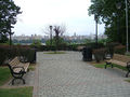 The thoroughfare is lined with many parks and scenic outlooks.
 -
![Bust of Thomas M. Donnelly, whose contributions helped save the Palisades[citation needed]](//upload.wikimedia.org/wikipedia/commons/thumb/a/a3/ThomasMDonnellyMonument.JPG/64px-ThomasMDonnellyMonument.JPG) Bust of Thomas M. Donnelly, whose contributions helped save the Palisades[citation needed]
Bust of Thomas M. Donnelly, whose contributions helped save the Palisades[citation needed] -
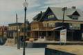
 In West New York at 60th Street, one of the few streets which connects it to the Hudson River waterfront
 -
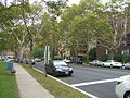 Apartment buildings and promenade in North Bergen
 -

![Bust of Thomas M. Donnelly, whose contributions helped save the Palisades[citation needed]](/File:ThomasMDonnellyMonument.JPG)


See also
- Hudson River Park, which has a Boulevard East and a Boulevard West
References
- ^ Morgen, Emmanuelle (February 21, 2022). "The Battle for a Protected Bike Lane on JFK Boulevard East". Fund for a Better Waterfront. Archived from the original on February 21, 2022. Retrieved March 10, 2022.
- ^ a b "New Jersey Towns May Consolidate" (PDF). The New York Times. June 18, 1911. Archived (PDF) from the original on July 20, 2021. Retrieved March 10, 2022.
- ^ Israel, Daniel (March 5, 2022). "Weehawken weighs protected bike lane versus parking spaces". The Hudson Reporter. Archived from the original on March 5, 2022. Retrieved March 10, 2022.
- ^ a b "Hudson County's Piers Swept By Second Big Fire in 3 Days". The New York Times. August 22, 1961. Retrieved July 26, 2022.
- ^ "Blasts Injure Boulevard" (PDF). The New York Times. New York City. May 5, 1905. Retrieved 2010-11-22.
- ^ A. G. Lichtenstein & Associates, Inc. for NJDOT and FHWA (2001). "Historic Bridge Survey (1991–1994)". New Jersey Department of Transportation. Retrieved January 20, 2017.
In 1892 the Hudson County Park Commission was created to plan a park and boulevard system like those provided in other cities such as Boston and Newark. The first feature the commission addressed was a county-long boulevard that would connect the future parks. The drive was called Hudson Boulevard (renamed John F. Kennedy Boulevard in the 1960s), and it became the principal north-south route in the county. It was constructed 1892-1897, under Chief Engineer Edlow W. Harrison, using existing roads in some places. In the southern part of the county it was built on New Bergen Point Road, and was thus an incarnation of the old King's Highway. From Bergen Point in Bayonne it wound north 14 miles almost to the Bergen County line, where it turned east in a loop through North Hudson Park and went south again as (Hudson) Boulevard East along the top edge of the Bergen Hill cliff to end at King's Bluff in Weehawken. The Boulevard East section was finished a few years later than the rest of the route. In 1908 the State of New Jersey reconstructed the road to "improve and beautify it." Although Hudson Boulevard became an important route in the county, and did connect the new parks, it has never been (for most of its route) the sort of continuous linear park feature that the term "boulevard" implies (Hudson County Park Commission, 1908.
- ^ "The old and the New - The Opposition and the Proposed Route" (PDF). The New York Times. August 12, 1873. Retrieved March 29, 2010.
- ^ a b "JERSEY CITY'S BICYCLE PARADE.; It Was Held Yesterday on the Hudson Boulevard and Was a Big Thing". The New York Times. August 30, 1896. Retrieved March 26, 2010.
- ^ "The old and the New - The Opposition and the Proposed Route" (PDF). The New York Times. August 12, 1873. Retrieved March 29, 2010.
- ^ "Opening the Boulevard" (PDF). The New York Times. 1896. Retrieved 2010-07-02.
- ^ a b "Short Runs Near Town Pleasant Now" (PDF). The New York Times. March 23, 1913.
- ^ "Save the Palisades Cyclists to work for this purpose and the Hudson County Boulevard" (PDF). The New York Times. November 11, 1895. Retrieved 2010-12-06.
- ^ Review of Boulevard East Archived July 3, 2009, at the Wayback Machine
- ^ 07086 USPS Box
- ^ "Welcome to Hudson County" Archived 2011-06-09 at the Wayback Machine. United Brokers. Accessed July 7, 2010
- ^ Sulzberger, A.G. (May 4, 2009). "July 4 Fireworks Show Moves to Hudson River". The New York Times. Retrieved 2011-07-07.
- The Union City Reporter. p. 17
- ^ Kocieniewski, David (July 1, 2009). "Relishing the View to a Spectacle on the Hudson". The New York Times.
- ^ Wright, E. Assata. "Where to see Fourth of July fireworks". The Union City Reporter, pp. 1, 10 and 11
- ^ Meinis, John (October 26, 2011), "Formula One racing coming to Weehawken, West New York", The Jersey Journal, retrieved 2011-10-27
- ^ Schultz, Johnathon (October 26, 2011), "Plan for a New York Area Formula One Race Announced in New Jersey", The New York Times, retrieved 2011-10-27
- ISBN 978-0-7385-6268-1.
- ^ Schwartz, Art (December 29, 2013). "Hopper comes home Woman buys modern version of $40M painting depicting her house on Boulevard East". The Hudson Reporter. Archived from the original on January 9, 2014. Retrieved January 7, 2013.
- ^ Hague, Jim (November 15, 2002). "Saving the Palisades Documentary, shown at Weehawken Public Library, portrays women's role in preserving cliffs". Hudson Reporter.
- ^ Gibson, Denise. "Late West New York mayor inducted into Hall of Fame". NJ.com. January 12, 2009.
- ^ "Hudson County High Point, New Jersey". Peakbagger.com. Retrieved July 7, 2010.
- ^ "Moments of silence". The Union City Reporter. September 11, 2005. p. 1
- ISBN 978-0-88097-763-0.
- ^ "Historic Bridge Survey (1991-1994)" (PDF). NJDOT. 2001. Retrieved 2013-03-26.
- ^ Tat, Linh (March 25, 2013). "6-month 'headache' due on Boulevard East in North Bergen". The Record. Retrieved 2013-03-26.
- ^ Conte, Michaelangelo (March 26, 2013). "A section of Boulevard East shutting down for four months during replacement of supporting arch". The Jersey Journal. Retrieved 2013-03-27.
- ^ a b Google (January 15, 2017). "Boulevard East" (Map). Google Maps. Google. Retrieved January 15, 2017.
- ^ "Hudson County 677 II straight line diagram" (PDF). New Jersey Department of Transportation. Retrieved 2009-09-14.[dead link]
- ^ "Hudson County 693 straight line diagram" (PDF). New Jersey Department of Transportation. Retrieved 2014-11-27.
- ^ "300 Boulevard East" Archived 2011-01-28 at the Wayback Machine. Telx. Retrieved October 26, 2011.
- New Jersey Transit. August 31, 2013. Retrieved January 5, 2014.
External links
- "Best of Boulevard East". Hudson County Office of Cultural and Heritage Affairs/Tourism Development. June 25, 2021. Archived from the original on February 21, 2022.