
Britsum
Britsum | ||
|---|---|---|
Village | ||
Postal code 9055[1] | ||
| Dialing code | 058 | |
The village of Britsum is located in the municipality of
Friesland), in the Netherlands. Britsum was built on an artificial bank (terp) running along the eastern side of the former Middelzee. The church, built around 1300, is also located on this bank. It had a population of about 910 citizens in January 2017.[3]
History
It was first mentioned in 944 as Bruggiheim, and means "settlement near a bridge".[4] Britsum is a terp (artificial living mound) village with a radial structure. It dates from the early middle ages and was built near the Middelzee. A large part of the mound was excavation around 1900.[5]
The western side of the Dutch Reformed church dates between 1180 and 1200. The nave and choir date between 1240 and 1260. The church received its present shape in 1875.[5] In 1840, Britsum was home to 326 people.[6]
Britsum was served by a station on the
North Friesland Railway which opened in 1901 and closed to passengers in December 1940. The line finally closed in 1997.[7]
Before 2018, the village was part of the Leeuwarderadeel municipality.[6]
Gallery
-
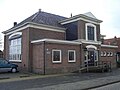 Former school building
 -
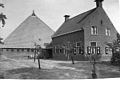 Farm in Britsum


References
- ^ a b c "Kerncijfers wijken en buurten 2021". Central Bureau of Statistics. Retrieved 30 March 2022.
two entries
- ^ "Postcodetool for 9055LN". Actueel Hoogtebestand Nederland (in Dutch). Het Waterschapshuis. Retrieved 30 March 2022.
- ^ Kerncijfers wijken en buurten 2017 - CBS Statline
- ^ "Britsum - (geografische naam)". Etymologiebank (in Dutch). Retrieved 30 March 2022.
- ^ ISBN 90 400 9476 4. Retrieved 30 March 2022.
- ^ a b "Britsum". Plaatsengids (in Dutch). Retrieved 30 March 2022.
- ^ "stopplaats Britsum". Stationsweb (in Dutch). Retrieved 30 March 2022.
External links
![]() Media related to Britsum at Wikimedia Commons
Media related to Britsum at Wikimedia Commons