
Brna
This article needs additional citations for verification. (January 2015) |
Brna | |
|---|---|
 Brna and the bay of Istruga from the air | |
 Brna Location of Brna in Croatia | |
| Coordinates: 42°54′22″N 16°51′38″E / 42.90611°N 16.86056°E | |
| Country | |
| County | Dubrovnik-Neretva County |
Brna is a village on the southern coast of the island of Korčula in western Croatia.
In the 19th century, Brna served as an overnight base for fishermen from nearby Smokvica, and had a pier that was used for the export of wine. During the 1970s, the village became populated with summer homes for Smokvica residents, and now caters to tourists with a hotel complex and numerous apartments.[citation needed]
To the northwest is the bay of Istruga, with deposits of
therapeutic mud
.
-
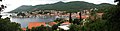 Brna is situated on a sheltered bay that opens to the south-west.
 -
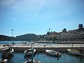 Brna center view on "Mali" and "Veli" Mol
 -
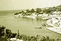 Brna in the 1960s


External links
Wikimedia Commons has media related to Brna.