
Broadway–Lafayette Street/Bleecker Street station
Broadway–Lafayette Street/ Bleecker Street SIM33 | |||||||||||||||
|---|---|---|---|---|---|---|---|---|---|---|---|---|---|---|---|
| Other information | |||||||||||||||
| Opened | May 19, 1957 (IND–southbound IRT) September 25, 2012 (IND–northbound IRT) | ||||||||||||||
| Accessible | |||||||||||||||
| Traffic | |||||||||||||||
| 2023 | 9,268,403[2] | ||||||||||||||
| Rank | 21 out of 423[2] | ||||||||||||||
| |||||||||||||||
| |||||||||||||||
| |||||||||||||||


The Broadway–Lafayette Street/Bleecker Street station is a
The complex comprises two stations, Bleecker Street and Broadway–Lafayette Street. The Bleecker Street station was built for the Interborough Rapid Transit Company (IRT), and was a local station on the city's first subway line, which was approved in 1900. The station opened on October 27, 1904, as one of the original 28 stations of the New York City Subway. The Broadway–Lafayette Street station was built as an express station for the Independent Subway System (IND) and opened on January 1, 1936.
The Bleecker Street station has two
History
IRT Lexington Avenue Line
Construction and opening
Planning for a subway line in New York City dates to 1864.[3]: 21 However, development of what would become the city's first subway line did not start until 1894, when the New York State Legislature passed the Rapid Transit Act.[3]: 139–140 The subway plans were drawn up by a team of engineers led by William Barclay Parsons, the Rapid Transit Commission's chief engineer. It called for a subway line from New York City Hall in lower Manhattan to the Upper West Side, where two branches would lead north into the Bronx.[4]: 3 A plan was formally adopted in 1897,[3]: 148 and all legal conflicts concerning the route alignment were resolved near the end of 1899.[3]: 161 The Rapid Transit Construction Company, organized by John B. McDonald and funded by August Belmont Jr., signed the initial Contract 1 with the Rapid Transit Commission in February 1900,[5] in which it would construct the subway and maintain a 50-year operating lease from the opening of the line.[3]: 165 In 1901, the firm of Heins & LaFarge was hired to design the underground stations.[4]: 4 Belmont incorporated the Interborough Rapid Transit Company (IRT) in April 1902 to operate the subway.[3]: 182
The Bleecker Street station was constructed as part of the route segment from Chambers Street to Great Jones Street. Construction on this section of the line began on July 10, 1900, and was awarded to Degnon-McLean Contracting Company.[5] In the vicinity of the Bleecker Street station, the subway was to run under Lafayette Street,[6][7]: 17 a new thoroughfare constructed between 1897[8] and 1905.[9] This involved widening, connecting, and renaming two formerly unconnected streets: Elm Street, which ran south of Houston Street, and Lafayette Place, which ran north of Great Jones Street to an intersection with Astor Place.[6][7]: 17–18 [10] The southward extension of Lafayette Street and the construction of the subway required the demolition or underpinning of several buildings in the street's path. This resulted in the creation of narrow land lots on either side of Lafayette Street between Houston and Great Jones Streets, an area that included the Bleecker Street station's site.[6][7]: 18 Even after the subway was completed, many of the narrow lots on Lafayette Street remained undeveloped for decades.[6]
During the station's construction in 1903, a portion of the ceiling collapsed,
1900s to 1930s
Shortly after the station opened, IRT workers allowed advertisers to place more than 40 advertisements on the walls,[16][17] even though the Rapid Transit Commission had banned the IRT from displaying ads in stations.[18] The IRT proposed modifying the ads so they harmonized with the station's architecture,[19] but the Municipal Art Society wanted the ads to be taken down because they overlapped with the name tablets on the walls.[20] Legal disputes over the advertisements continued until 1907, when a New York Supreme Court judge ruled that the IRT could display advertising at stations.[21]
To address overcrowding, in 1909, the New York Public Service Commission proposed lengthening the platforms at stations along the original IRT subway.[22]: 168 As part of a modification to the IRT's construction contracts made on January 18, 1910, the company was to lengthen station platforms to accommodate ten-car express and six-car local trains. In addition to $1.5 million (equivalent to $49.1 million in 2023) spent on platform lengthening, $500,000 (equivalent to $16.4 million in 2023) was spent on building additional entrances and exits. It was anticipated that these improvements would increase capacity by 25 percent.[23]: 15 The Bleecker Street station's northbound platform was extended north by 30 feet (9.1 m), while the southbound platform was extended south by 25 feet (7.6 m).[23]: 107 Six-car local trains began operating in October 1910.[22]: 168
In December 1922, the Transit Commission approved a $3 million project to lengthen platforms at 14 local stations along the original IRT line, including Bleecker Street and seven other stations on the Lexington Avenue Line. Platform lengths at these stations would be increased from 225 to 436 feet (69 to 133 m).[24][25] The commission postponed the platform-lengthening project in September 1923, at which point the cost had risen to $5.6 million.[26][27] The commission again considered lengthening the IRT platforms at Bleecker Street in December 1927.[28][29] At the end of the month, the Transit Commission requested that the IRT create plans to lengthen the platforms at Bleecker Street and three other Lexington Avenue Line stations to 480 feet (150 m).[30] The northbound platform at Bleecker Street needed to be lengthened by 251 feet (77 m), while the southbound platform needed to be lengthened 255 feet (78 m); both platforms could be extended to either the north or south.[31] The federal government placed an injunction against the commission's platform-lengthening decree, which remained in place for over a year. By 1929, the New York City Board of Transportation had not yet drawn up plans for the Bleecker Street station.[32]
1940s to 2000s
The city government took over the IRT's operations on June 12, 1940.[33][34] The New York City Board of Transportation issued a $1.97 million contract in early 1947 to extend the southbound IRT platforms at Bleecker Street and Spring Street to fit ten-car trains.[35][36] The work was finished the next year.[36]
In late 1959, contracts were awarded to extend the platforms at
In 1979, the New York City Landmarks Preservation Commission designated the space within the boundaries of the original Bleecker Street station, excluding expansions made after 1904, as a city landmark.[4] The station was designated along with eleven others on the original IRT.[4][39] The IRT station was renovated in the late 1980s, but the renovation was delayed by one year because the project had to be redesigned to conform to landmark regulations.[40] High entry-exit turnstiles were added at the Bleecker Street entrance to the southbound platform in 1998. The previous turnstiles at that entrance, which had dated from the 1930s, often malfunctioned and did not allow passengers to enter.[41] The Bleecker Street station's original interiors were listed on the National Register of Historic Places in 2004.[15]
IND Sixth Avenue Line
Construction and opening
New York City mayor John Francis Hylan's original plans for the Independent Subway System (IND), proposed in 1922, included building over 100 miles (160 km) of new lines and taking over nearly 100 miles (160 km) of existing lines, which would compete with the IRT and the Brooklyn–Manhattan Transit Corporation (BMT), the two major subway operators of the time.[42][43] The IND Sixth Avenue Line was designed to replace the elevated IRT Sixth Avenue Line.[44] The first portion of the line to be constructed was then known as the Houston–Essex Street Line, which ran under Houston, Essex, and Rutgers Streets. The contract for the line was awarded to Corson Construction in January 1929,[45] and construction of this section officially started in May 1929.[46]
In 1930, the
The Broadway–Lafayette Street station opened on January 1, 1936, as one of the first four stations on the Houston–Essex Street Line, the first part of the Sixth Avenue Line.
1940s to 1990s
By the early 1990s, many homeless people were sheltered within the Broadway–Lafayette Street station and the tunnels near it.[56][57] Newsday wrote in 1992: "This one subway station has enough hidden corners, secret passages, dead-end mezzanines and staircases to nowhere to accommodate half the homeless population of New York."[56] The high homeless population at the Broadway–Lafayette Street station, and at the adjacent Second Avenue station, was attributed to their proximity to the rundown Bowery neighborhood.[58] The Metropolitan Transportation Authority (MTA), which operated the subway system, removed several benches from the station in 1990 to dissuade homeless people from staying there.[57] The benches were reinstalled after homeless advocates objected.[59] The MTA also removed two of the station's high entry-exit turnstiles in 1992 to increase passenger flow.[60] In April 1993, the New York State Legislature agreed to give the MTA $9.6 billion for capital improvements. Some of the funds would be used to renovate nearly one hundred New York City Subway stations,[61][62] including Broadway–Lafayette Street.[63]
Consolidation into single complex
Southbound transfer
A free transfer passageway from the southbound IRT platform to the IND platform opened on May 19, 1957,[64] after the IRT station's platforms had been lengthened to fit ten-car trains.[65] This one-way transfer was purely coincidental and was not intended in the original construction.[66] The construction of a connection from the northbound platform would have required more extensive construction, including knocking down support walls and digging a tunnel. The northbound platform was extended two car lengths to the north because it was easier to do and cost less.[65] As a result, a free transfer was not available to the northbound platform. Passengers had to exit the IND station, walk one block north to Bleecker Street, and pay an additional fare.[67]
For several decades, the Bleecker Street and Broadway–Lafayette Street stations were the only place in the system where a free transfer was possible only in one direction. As a result, riders heading to or from the northbound IRT had to transfer at other stations, such as the Atlantic Avenue–Pacific Street station and the Jay Street–Lawrence Street station in Brooklyn.[68] Most passengers transferring between the IND and the uptown IRT platform continued to pay an additional fare, except for holders of unlimited-ride MetroCards, after that option was introduced in the 1990s.[67] According to transit historian Clifton Hood, the lack of a northbound transfer was a "pretty late holdover" from the era prior to the unification of the city's three subway systems in 1940.[69]
Northbound transfer
A transfer between the IND platforms and the uptown IRT platform had been planned since 1989, when the project was included in the MTA's third capital program.[70] Construction on the transfer would have started in 1992 pending the approval of the program by the State Legislature. The MTA estimated that 15,000 daily passengers would use the free transfer.[65] The MTA contemplated providing a free transfer between the IND and northbound IRT platforms during the late 1990s. This would have alleviated congestion caused by the closure of the Manhattan Bridge's northern pair of subway tracks, which resulted in numerous service changes at the IND station.[71][72] By 1998, this transfer was no longer being planned.[41]
Further progress on the IND/IRT transfer stalled until 2005, when the MTA announced that it would renovate the complex in its 2005–2009 capital program.[67][73] The project was to cost $50 million, including $9.2 million for the IRT platforms' renovation, $8.9 million for ADA-accessible elevators, and $31.9 million for a free transfer to the uptown IRT platform.[67] An escalator connected the uptown platform of the Broadway-Lafayette Street station with a new transfer mezzanine that connected riders to the uptown platform of the Bleecker Street station. In addition, elevators were installed to connect the various platforms of the IND station, and those of Bleecker Street.[74] The transfer contained new elevators and escalators to the IND station below. The street-level elevator accesses the southbound IRT platform directly, while four other elevators in the station connect each IND platform with each IRT platform.[75]
On March 26, 2012, the uptown platform was shifted south to the newly constructed extension, and the 1950s northern extension closed at the same time. At the time, the MTA stated that the transfer to the uptown Bleecker Street platform would be completed at the end of June.[76] The uptown transfer did not fully open until September 25, 2012.[68][77] The overall cost of the rehabilitation project had climbed to $127 million.[78][69] The MTA estimated that the free transfer would benefit 30,000 riders daily;[69][79] by then, the complex had 11.6 million passengers annually.[69] The New York Daily News wrote: "Thus will be completed the grand project, begun 72 years ago under Mayor Fiorello LaGuardia, of unifying the subways, the great unifier of New York."[77]
Service history
IRT station
After the first subway line was completed in 1908,
IND station
When the IND station opened, it was served by
On November 26, 1967, the first part of the
When the Manhattan Bridge's north tracks were closed for repairs between 1986 and 1988, the Sixth Avenue Shuttle stopped at the station, running from 57th Street to Grand Street.[96] The Q train started running along the Sixth Avenue Line's express tracks in 1988[97] and continued to operate on the line until 2001.[98] The Grand Street Shuttle operated from Broadway–Lafayette Street to Grand Street during 1995,[99] and again between July 2001[98] and 2004, when the Manhattan Bridge's north tracks were again closed.[100] The V train, which used the Sixth Avenue Line's local tracks, began serving the station in December 2001.[101] The V train was discontinued in 2010 and replaced by the M train, which began using the Williamsburg Bridge connection east of the station.[102]
Station layout
| Ground | Street level | Exits/entrances |
| Basement 1 | East mezzanine | Fare control, exits to east side of Lafayette Street |
| Side platform | ||
| Northbound local | ← ← | |
| Northbound express | ← | |
| Southbound express | | |
| Southbound local | | |
| Side platform | ||
| West mezzanine | Fare control, station agent, exits to Houston Street and west side of Lafayette Street | |
| Basement 2 | Mezzanine | Transfer between platforms |
| Basement 3 | Northbound local | ← ← |
| Island platform | ||
| Northbound express | ← ← | |
| Southbound express | | |
| Island platform | ||
| Southbound local | | |
A passageway connects the downtown IRT platform under Lafayette Street and the mezzanine at Broadway. There is a lower level mezzanine for the IND underneath the IRT platforms.
Art
The 1998 artwork in the IND station is called Signal by Mel Chin.
As part of the MTA Arts & Design program, Leo Villareal created a light installation called Hive in 2012.[105] It is located at the newest section of the uptown IRT platform in the mezzanine providing the transfer to the IND station.[106][107] The work consists of hexagonal lights that can change color.[106][108] The shapes used in the installation was inspired by shapes created by mathematician John Horton Conway. According to Sandra Bloodworth of MTA Arts & Design, the artwork was intended to help passengers navigate the complex; she stated in 2016 that the installation "really resonates with the activity of the station, the people waiting on the platform, this ever-changing lighting artwork".[107]
Exits

The station has a total of 12 staircase entrances and one elevator entrance. They are clustered in three locations: the intersection of Broadway and Houston Street, the intersection of Lafayette and Houston Streets, and the intersection of Lafayette and Bleecker Streets, The exits at Houston Street primarily serve the IND platforms while the exits at Lafayette Street primarily serve the IRT platforms. The northbound IRT platform's exits are on the eastern side of Lafayette Street while the southbound platform's exits are on the western side.[109]
There are two stairs at Broadway and Houston Street, one at either eastern corner.[109] The southeastern one is built inside a building. It leads to the full-time entrance to the IND station, above the center of that station, which contains a turnstile bank and token booth.[110] There are closed staircases from the extreme western ends of both platforms that lead to a western mezzanine with exits to the west side of Broadway and Houston Street. It is currently used by employees.
The upper IND mezzanine has two fare control areas that are shared with the southbound IRT platform. A set of turnstiles on the south side leads to two staircases at the southeast corner of Lafayette and Houston Streets. Another set of turnstiles on the north side leads to a stair and an elevator on the northwest corner of Lafayette and Houston Streets. The extreme east end of the IND station contains stairs and escalators to the eastern mezzanine, which is shared with the northbound IRT platform. This mezzanine contains two stairs, one to each eastern corner of Houston and Lafayette Streets.[109]
There are five stairs near Lafayette and Bleecker Streets. One stair each goes to the northwestern and southwestern corners of Lafayette and Bleecker Streets, and serve the southbound IRT platform. One stair each goes to the northeastern, southwestern, and southeastern corners of Mulberry and Bleecker Streets, and serve the northbound IRT platform.[15]: 4 [109]
IRT Lexington Avenue Line platforms
Bleecker Street <6> | |||||||||||||||||||||||||||||||||||||||||||||||||||||||||||||||||||||||||||||||||||||||||
|---|---|---|---|---|---|---|---|---|---|---|---|---|---|---|---|---|---|---|---|---|---|---|---|---|---|---|---|---|---|---|---|---|---|---|---|---|---|---|---|---|---|---|---|---|---|---|---|---|---|---|---|---|---|---|---|---|---|---|---|---|---|---|---|---|---|---|---|---|---|---|---|---|---|---|---|---|---|---|---|---|---|---|---|---|---|---|---|---|---|
| Structure | Underground | ||||||||||||||||||||||||||||||||||||||||||||||||||||||||||||||||||||||||||||||||||||||||
| Platforms | 2 side platforms | ||||||||||||||||||||||||||||||||||||||||||||||||||||||||||||||||||||||||||||||||||||||||
| Tracks | 4 | ||||||||||||||||||||||||||||||||||||||||||||||||||||||||||||||||||||||||||||||||||||||||
| Other information | |||||||||||||||||||||||||||||||||||||||||||||||||||||||||||||||||||||||||||||||||||||||||
| Opened | October 27, 1904[14] | ||||||||||||||||||||||||||||||||||||||||||||||||||||||||||||||||||||||||||||||||||||||||
| Accessible | |||||||||||||||||||||||||||||||||||||||||||||||||||||||||||||||||||||||||||||||||||||||||
| Opposite- direction transfer | Yes | ||||||||||||||||||||||||||||||||||||||||||||||||||||||||||||||||||||||||||||||||||||||||
| |||||||||||||||||||||||||||||||||||||||||||||||||||||||||||||||||||||||||||||||||||||||||
| |||||||||||||||||||||||||||||||||||||||||||||||||||||||||||||||||||||||||||||||||||||||||
| |||||||||||||||||||||||||||||||||||||||||||||||||||||||||||||||||||||||||||||||||||||||||
Bleecker Street Subway Station (IRT) | |||||||||||||||||||||||||||||||||||||||||||||||||||||||||||||||||||||||||||||||||||||||||
New York City Landmark No. 1096 | |||||||||||||||||||||||||||||||||||||||||||||||||||||||||||||||||||||||||||||||||||||||||
MPS | New York City Subway System MPS | ||||||||||||||||||||||||||||||||||||||||||||||||||||||||||||||||||||||||||||||||||||||||
| NRHP reference No. | 04001012[15] | ||||||||||||||||||||||||||||||||||||||||||||||||||||||||||||||||||||||||||||||||||||||||
| NYCL No. | 1096 | ||||||||||||||||||||||||||||||||||||||||||||||||||||||||||||||||||||||||||||||||||||||||
| Significant dates | |||||||||||||||||||||||||||||||||||||||||||||||||||||||||||||||||||||||||||||||||||||||||
| Added to NRHP | September 17, 2004 | ||||||||||||||||||||||||||||||||||||||||||||||||||||||||||||||||||||||||||||||||||||||||
| Designated NYCL | October 23, 1979[4] | ||||||||||||||||||||||||||||||||||||||||||||||||||||||||||||||||||||||||||||||||||||||||
The Bleecker Street station is a local station on the
Design
As with other stations built as part of the original IRT, the station was constructed using a
The
The ceilings of the original platforms and fare control areas contain plaster molding.[15]: 4–5 [115]: 10 Originally, the ceiling was painted white and yellow. Each platform also had three ticket windows, placed between the stairways leading to the street.[117] The northbound platform contains doorways that formerly led to men's and women's restrooms, with corresponding marble lintels.[15]: 5
The northern platform extension of the northbound platform, now walled off, had green tiles and a darker green trim line with "BLEECKER ST" written on it in black sans serif font at regular intervals. These tiles were installed during the late 1950s renovation. The platform extension of the southbound platform had similar tiles, which were removed in the 2012 extension.
Gallery
-
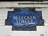 Faience name tablet, Heins & LaFarge/Grueby Faience Company, from 1904
 -
 Original cartouche
 -
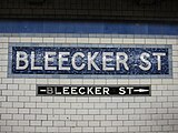 Pre-renovation Mosaic station tablets by Vickers
 -
 Southbound stairway at street
 -
 The station used to have skylights to let in natural light (1905)


IND Sixth Avenue Line platforms
Broadway–Lafayette Street | |||||||||||||||||||||||||||||||||||||||||||||||||||||||||||||||||||||||||||||||||||||||||||||||||||||||||||||||||||||||||||||||||||
|---|---|---|---|---|---|---|---|---|---|---|---|---|---|---|---|---|---|---|---|---|---|---|---|---|---|---|---|---|---|---|---|---|---|---|---|---|---|---|---|---|---|---|---|---|---|---|---|---|---|---|---|---|---|---|---|---|---|---|---|---|---|---|---|---|---|---|---|---|---|---|---|---|---|---|---|---|---|---|---|---|---|---|---|---|---|---|---|---|---|---|---|---|---|---|---|---|---|---|---|---|---|---|---|---|---|---|---|---|---|---|---|---|---|---|---|---|---|---|---|---|---|---|---|---|---|---|---|---|---|---|---|
| Structure | Underground | ||||||||||||||||||||||||||||||||||||||||||||||||||||||||||||||||||||||||||||||||||||||||||||||||||||||||||||||||||||||||||||||||||
| Platforms | 2 island platforms cross-platform interchange | ||||||||||||||||||||||||||||||||||||||||||||||||||||||||||||||||||||||||||||||||||||||||||||||||||||||||||||||||||||||||||||||||||
| Tracks | 4 | ||||||||||||||||||||||||||||||||||||||||||||||||||||||||||||||||||||||||||||||||||||||||||||||||||||||||||||||||||||||||||||||||||
| Other information | |||||||||||||||||||||||||||||||||||||||||||||||||||||||||||||||||||||||||||||||||||||||||||||||||||||||||||||||||||||||||||||||||||
| Opened | January 1, 1936 | ||||||||||||||||||||||||||||||||||||||||||||||||||||||||||||||||||||||||||||||||||||||||||||||||||||||||||||||||||||||||||||||||||
| Accessible | |||||||||||||||||||||||||||||||||||||||||||||||||||||||||||||||||||||||||||||||||||||||||||||||||||||||||||||||||||||||||||||||||||
| Opposite- direction transfer | Yes | ||||||||||||||||||||||||||||||||||||||||||||||||||||||||||||||||||||||||||||||||||||||||||||||||||||||||||||||||||||||||||||||||||
| |||||||||||||||||||||||||||||||||||||||||||||||||||||||||||||||||||||||||||||||||||||||||||||||||||||||||||||||||||||||||||||||||||
| |||||||||||||||||||||||||||||||||||||||||||||||||||||||||||||||||||||||||||||||||||||||||||||||||||||||||||||||||||||||||||||||||||
| |||||||||||||||||||||||||||||||||||||||||||||||||||||||||||||||||||||||||||||||||||||||||||||||||||||||||||||||||||||||||||||||||||
The Broadway–Lafayette Street station on the
The centers of both platforms have three staircases that go up to a mezzanine, where wide staircases on either side go up to the station's three
Design
When the station opened, the walls adjacent to the tracks had white tiles with a blue tile band. The tile band was part of a color-coded tile system used throughout the IND.[122] The tile colors were designed to facilitate navigation for travelers going away from Lower Manhattan. Because the next station to the north, West Fourth Street–Washington Square, is an express station, the adjacent stations to the north and south both used different tile colors.[123][124]
Both outer track walls have been renovated with a blue trim line on a black border and small "BROADWAY" tile captions beneath in white lettering on a black background. Blue I-beam columns run along either side of both platforms at regular intervals with alternating ones having the standard black station name plate and white lettering.
Track layout
West (railroad north) of this station, there are crossovers between the two northbound tracks and a single one between the express tracks. The line turns north along Sixth Avenue and goes through a complex set of switches and crossovers with the
East (railroad south) of this station, there used to be a crossover between the two southbound tracks before they were reconfigured in 1967 by the
References
- ^ a b c "Glossary". Second Avenue Subway Supplemental Draft Environmental Impact Statement (SDEIS) (PDF). Vol. 1. Metropolitan Transportation Authority. March 4, 2003. pp. 1–2. Archived from the original (PDF) on February 26, 2021. Retrieved January 1, 2021.
- ^ a b "Annual Subway Ridership (2018–2023)". Metropolitan Transportation Authority. 2023. Retrieved April 20, 2024.
- ^ a b c d e f g h Walker, James Blaine (1918). Fifty Years of Rapid Transit — 1864 to 1917. New York, N.Y.: Law Printing. Retrieved November 6, 2016.
- ^ a b c d e f g h i "Interborough Rapid Transit System, Underground Interior" (PDF). New York City Landmarks Preservation Commission. October 23, 1979. Archived (PDF) from the original on September 21, 2020. Retrieved November 19, 2019.
- ^ a b Report of the Board of Rapid Transit Railroad Commissioners for the City of New York For The Year Ending December 31, 1904 Accompanied By Reports of the Chief Engineer and of the Auditor. Board of Rapid Transit Railroad Commissioners. 1905. pp. 229–236.
- ^ from the original on February 9, 2021. Retrieved February 2, 2021.
- ^ a b c Presa, Donald G. (June 29, 1999). "NoHo Historic District" (PDF). New York City Landmarks Preservation Commission. Archived (PDF) from the original on February 8, 2021. Retrieved February 2, 2021.
- (PDF) from the original on May 4, 2022. Retrieved February 2, 2021.
- (PDF) from the original on May 4, 2022. Retrieved February 2, 2021.
- ISBN 978-0-8232-1275-0.
- ^ ProQuest 1015861807.
- ^ from the original on May 26, 2023. Retrieved May 26, 2023.
- from the original on May 5, 2022. Retrieved May 10, 2022.
- ^ from the original on December 13, 2021. Retrieved April 21, 2020.
- ^ a b c d e f g h i j k l m "New York MPS Bleecker Street Subway Station (IRT)". Records of the National Park Service, 1785 - 2006, Series: National Register of Historic Places and National Historic Landmarks Program Records, 2013 - 2017, Box: National Register of Historic Places and National Historic Landmarks Program Records: New York, ID: 75313929. National Archives.
- ISSN 0362-4331. Retrieved May 26, 2023.
- ProQuest 571627710.
- from the original on May 7, 2023. Retrieved May 6, 2023.
- ProQuest 571494448.
- ProQuest 571629737.
- from the original on May 15, 2022. Retrieved May 9, 2023.
- ^ a b Hood, Clifton (1978). "The Impact of the IRT in New York City" (PDF). Historic American Engineering Record. pp. 146–207 (PDF pp. 147–208). Archived (PDF) from the original on January 17, 2021. Retrieved December 20, 2020.
 This article incorporates text from this source, which is in the public domain.
{{cite web}}: CS1 maint: postscript (link) - ^ a b Report of the Public Service Commission for the First District of the State of New York For The Year Ending December 31, 1910. Public Service Commission. 1911. Archived from the original on January 20, 2021. Retrieved January 7, 2021.
- from the original on June 21, 2022. Retrieved June 21, 2022.
- ProQuest 573974563.
- from the original on June 21, 2022. Retrieved June 21, 2022.
- ProQuest 1237290874.
- ISSN 0362-4331. Retrieved May 20, 2023.
- ProQuest 1132104986.
- ISSN 0362-4331. Retrieved May 20, 2023.
- ^ New York (State) Transit Commission (1927). Proceedings of the Transit Commission, State of New York. p. 865.
- ISSN 0362-4331. Retrieved May 26, 2023.
- from the original on January 7, 2022. Retrieved May 14, 2022.
- ProQuest 1248134780.
- from the original on September 14, 2021. Retrieved May 21, 2023.
- ^ a b Proceedings of the New York City Board of Transportation. New York City Board of Transportation. 1949. p. 1585. Archived from the original on May 21, 2023. Retrieved May 26, 2023.
- ^ a b Annual Report For The Year Ending June 30, 1959 (PDF). New York City Transit Authority. 1959. p. 9. Archived (PDF) from the original on May 11, 2021. Retrieved December 29, 2020.
- from the original on January 8, 2021. Retrieved January 4, 2021.
- from the original on March 9, 2018. Retrieved December 26, 2020.
- ProQuest 277960129.
- ^ from the original on May 26, 2023. Retrieved May 26, 2023.
- from the original on June 30, 2019. Retrieved August 1, 2019.
- from the original on June 28, 2019. Retrieved August 1, 2019.
- from the original on April 28, 2018. Retrieved April 27, 2018.
- from the original on May 6, 2022. Retrieved April 28, 2018.
- from the original on April 28, 2018. Retrieved April 28, 2018.
- from the original on June 30, 2018. Retrieved July 14, 2022.
- ProQuest 1113193574.
- ISSN 0362-4331. Retrieved June 11, 2023.
- ISSN 0362-4331. Retrieved June 11, 2023.
- ProQuest 1114790071.
- ISSN 0362-4331. Retrieved June 11, 2023.
- from the original on December 11, 2021. Retrieved October 7, 2011.
- ^ ProQuest 1325551854.
- ISSN 0362-4331. Retrieved June 11, 2023.
- ^ ProQuest 278477716.
- ^ from the original on May 26, 2023. Retrieved May 26, 2023.
- from the original on May 26, 2023. Retrieved May 26, 2023.
- ProQuest 427590185.
- ProQuest 1237383241.
- ^ Benenson, Joel (April 1, 1993). "Albany deal to save the $1.25 fare". New York Daily News. p. 1059. Archived from the original on April 28, 2023. Retrieved April 28, 2023.
- from the original on April 28, 2023. Retrieved April 28, 2023.
- ^ "Stop the Fussing". Newsday. May 28, 1993. p. 56. Archived from the original on May 3, 2023. Retrieved April 28, 2023.
- ^ "Passage Links Subways" (PDF). The New York Times. Archived from the original on May 6, 2022. Retrieved October 10, 2016.
- ^ a b c "Only In New York: The Newsletter of the New York City Transit Authority". New York City Transit Authority. 1990. Archived from the original on May 6, 2022. Retrieved April 7, 2019 – via Flickr.
- from the original on May 26, 2023. Retrieved May 26, 2023.
- ^ from the original on December 18, 2021. Retrieved May 30, 2022.
- ^ a b Flegenheimer, Matt (September 24, 2012). "A Vexing Flaw in the Subway Is Finally Fixed". The New York Times. pp. A18–A19. Archived from the original on September 27, 2012. Retrieved September 28, 2012.
- ^ ProQuest 1081798955.
- ^ "The New York Transit Authority in the 1980s". Archived from the original on September 6, 2017. Retrieved April 9, 2013.
- from the original on December 26, 2017. Retrieved May 26, 2023.
- ProQuest 367916706.
- ProQuest 305956784.
- ^ "Bleecker Street Station Rehabilitation Project WEIDLINGER ASSOCIATES INC". Archived from the original on August 13, 2016. Retrieved October 28, 2015.
- ^ "Bleecker Street Platform Shifts". MTA.info. March 26, 2012. Archived from the original on December 20, 2015. Retrieved March 27, 2012.
- ^ a b c "Bleecker Street Platform Shifts". MTA.info. March 26, 2012. Archived from the original on August 17, 2012. Retrieved March 27, 2012.
- ^ ProQuest 1069269210.
- ^ Redwine, Tina (September 25, 2012). "Transfers At Bleecker Street Are No Longer A Bleak Situation". NY1. Archived from the original on January 30, 2013. Retrieved September 26, 2012.
- ProQuest 1079028558.
- ^ "Our First Subway Completed At Last — Opening of the Van Cortlandt Extension Finishes System Begun in 1900 — The Job Cost $60,000,000 — A Twenty-Mile Ride from Brooklyn to 242d Street for a Nickel Is Possible Now". The New York Times. August 2, 1908. p. 10. Archived from the original on December 23, 2021. Retrieved November 6, 2016.
- ^ Herries, William (1916). Brooklyn Daily Eagle Almanac. Brooklyn Daily Eagle. p. 119. Archived from the original on May 11, 2021. Retrieved December 25, 2020.
- ^ "Open New Subway Lines to Traffic; Called a Triumph — Great H System Put in Operation Marks an Era in Railroad Construction — No Hitch in the Plans — But Public Gropes Blindly to Find the Way in Maze of New Stations — Thousands Go Astray — Leaders in City's Life Hail Accomplishment of Great Task at Meeting at the Astor" (PDF). The New York Times. August 2, 1918. p. 1. Archived (PDF) from the original on February 21, 2021. Retrieved November 6, 2016.
- ^ Brown, Nicole (May 17, 2019). "How did the MTA subway lines get their letter or number? NYCurious". amNewYork. Archived from the original on March 2, 2021. Retrieved January 27, 2021.
- ^ Friedlander, Alex; Lonto, Arthur; Raudenbush, Henry (April 1960). "A Summary of Services on the IRT Division, NYCTA" (PDF). New York Division Bulletin. 3 (1). Electric Railroaders' Association: 2–3. Archived (PDF) from the original on September 14, 2020. Retrieved January 27, 2021.
- from the original on June 14, 2018. Retrieved October 7, 2011.
- from the original on December 11, 2021. Retrieved October 7, 2011.
- from the original on April 16, 2018. Retrieved April 15, 2018.
- ProQuest 1263396247.
- ISSN 0362-4331. Retrieved February 20, 2016.
- ProQuest 1327502691.
- ISSN 0362-4331. Retrieved February 20, 2016.
- ProQuest 1322560409.
- from the original on December 11, 2021. Retrieved August 23, 2015.
- from the original on November 28, 2016. Retrieved November 27, 2016.
- from the original on September 16, 2017. Retrieved July 26, 2017.
- ^ Annual Report on 1989 Rapid Routes Schedules and Service Planning. New York City Transit Authority, Operations Planning Department. June 1, 1990. p. 56.
- from the original on March 6, 2016. Retrieved May 16, 2023.
- ^ from the original on September 29, 2015. Retrieved May 16, 2023.
- from the original on March 29, 2019. Retrieved March 29, 2019.
- from the original on October 18, 2022. Retrieved November 5, 2016.
- from the original on March 25, 2010. Retrieved October 14, 2016.
- ^ DeJesus, Juan (June 25, 2010). "Last Stop: New Yorkers Bid Adieu to V and W". WNBC. Retrieved June 25, 2010.
- ^ a b c "Arts & Design - NYCT Permanent Art". MTA. Archived from the original on June 15, 2022. Retrieved May 30, 2022.
- ^ ProQuest 313626699.
- ^ "Hive (Bleecker Street)". MTA. Retrieved May 30, 2022.
- ^ a b Redwine, Tina (July 21, 2012). "MTA Unveils Digital Art At Bleecker Street Station". NY1. Archived from the original on July 24, 2012. Retrieved July 22, 2012.
- ^ ProQuest 1765329497.
- ^ Dailey, Jessica (July 31, 2012). "Blinged Out Bleecker Street Station Has Color-Changing Lights". Curbed NY. Archived from the original on July 1, 2022. Retrieved May 30, 2022.
- ^ a b c d "MTA Neighborhood Maps: Bleecker St (6)". Metropolitan Transportation Authority. 2018. Archived from the original on August 29, 2021. Retrieved December 25, 2020.
- ^ Downtown Bleecker Street/Broadway–Lafayette Street On NY Turf Retrieved August 28, 2008 Archived July 17, 2011, at the Wayback Machine
- ^ a b "6 Subway Timetable, Effective August 12, 2023". Metropolitan Transportation Authority. Retrieved August 26, 2023.
- ^ "4 Subway Timetable, Effective December 4, 2022". Metropolitan Transportation Authority. Retrieved August 26, 2023.
- ^ OCLC 49777633 – via Google Books.
- ^ a b "Subway Map" (PDF). Metropolitan Transportation Authority. September 2021. Retrieved September 17, 2021.
- ^ a b c d e f g Framberger, David J. (1978). "Architectural Designs for New York's First Subway" (PDF). Historic American Engineering Record. pp. 1–46 (PDF pp. 367–412). Archived (PDF) from the original on January 17, 2021. Retrieved December 20, 2020. This article incorporates text from this source, which is in the public domain.
{{cite web}}: CS1 maint: postscript (link) - ^ Scott, Charles (1978). "Design and Construction of the IRT: Civil Engineering" (PDF). Historic American Engineering Record. pp. 208–282 (PDF pp. 209–283). Archived (PDF) from the original on January 17, 2021. Retrieved December 20, 2020. This article incorporates text from this source, which is in the public domain.
{{cite web}}: CS1 maint: postscript (link) - ^ from the original on May 27, 2023. Retrieved May 26, 2023.
- ^ "B Subway Timetable, Effective December 4, 2022". Metropolitan Transportation Authority. Retrieved August 26, 2023.
- ^ "D Subway Timetable, Effective January 23, 2023". Metropolitan Transportation Authority. Retrieved August 26, 2023.
- ^ "F Subway Timetable, Effective August 28, 2023". Metropolitan Transportation Authority. Retrieved August 26, 2023.
- ^ "M Subway Timetable, Effective August 28, 2023". Metropolitan Transportation Authority. Retrieved August 26, 2023.
- from the original on July 1, 2022. Retrieved July 1, 2022.
- ^ Carlson, Jen (February 18, 2016). "Map: These Color Tiles In The Subway System Used To Mean Something". Gothamist. Archived from the original on May 10, 2023. Retrieved May 10, 2023.
- ^ Gleason, Will (February 18, 2016). "The hidden meaning behind the New York subway's colored tiles". Time Out New York. Archived from the original on May 10, 2023. Retrieved May 10, 2023.
External links
| External videos | |
|---|---|
![]() Media related to Bleecker Street / Broadway – Lafayette Street (New York City Subway) at Wikimedia Commons
Media related to Bleecker Street / Broadway – Lafayette Street (New York City Subway) at Wikimedia Commons
- Forgotten NY – Original 28 - NYC's First 28 Subway Stations
nycsubway.org
- nycsubway.org – IRT East Side Line: Bleecker Street
- nycsubway.org – IND 6th Avenue: Broadway/Lafayette
- nycsubway.org – Signal Artwork by Mel Chin (1998) Archived May 20, 2012, at the Wayback Machine
Station Reporter
MTA's Arts For Transit
Google Maps Street View
- Bleecker Street entrance Archived November 12, 2012, at the Wayback Machine
- Broadway entrance Archived November 11, 2012, at the Wayback Machine
- Lafayette Street entrance Archived May 6, 2022, at the Wayback Machine
- Mulberry Street entrance Archived May 6, 2022, at the Wayback Machine
- IRT platforms and transfer Archived May 6, 2022, at the Wayback Machine
- IND platforms Archived May 6, 2022, at the Wayback Machine