
Delancey Street/Essex Street station
Delancey Street/Essex Street B39 | |||||||||||
|---|---|---|---|---|---|---|---|---|---|---|---|
| Structure | Underground | ||||||||||
| Levels | 2 | ||||||||||
| Other information | |||||||||||
| Opened | July 1, 1948 | ||||||||||
| Accessible | not ADA-accessible; accessibility planned | ||||||||||
| Traffic | |||||||||||
| 2023 | 7,083,681[2] | ||||||||||
| Rank | 29 out of 423[2] | ||||||||||
| |||||||||||
| |||||||||||
| |||||||||||


The Delancey Street/Essex Street station is a
. It is served by the:- Jtrains at all times
- M train at all times except late nights
- <F>trains during rush hours in the peak direction
In addition to the two track levels—the
Station layout
| G | Street level | Exit and entrance |
| B1 | North mezzanine | Fare control |
| Side platform | ||
| Westbound[note 1] | ← ← ← | |
| Center track[note 1] | | |
| Island platform | ||
| Eastbound[note 1] | | |
| Trolley trackways | Emergency exit, former trackbed, proposed Lowline | |
| B2 | South mezzanine | Fare control, exits/entrances |
| B3 | Side platform | |
| Northbound | ← | |
| Southbound | | |
| Side platform | ||
Since June 2010, both the F and the M operate local along the
Exits
| Exit location[6] | Number of exits |
|---|---|
| NW corner of Delancey Street and Essex Street | 1 stair |
| SW corner of Delancey Street and Essex Street | 1 stair |
| NE corner of Delancey Street and Essex Street | 1 stair 1 HEET
|
| SE corner of Delancey Street and Essex Street | 1 stair 1 HEET
|
| NW corner of Delancey Street and Norfolk Street | 1 stair |
| NE corner of Delancey Street and Norfolk Street | 1 stair |
Both the IND and the BMT stations have additional closed exits. The IND station had four additional exits; two were at both the north end of the station at
As part of the construction of the nearby Essex Crossing development, Site 9, which is located at 120 Essex Street (between Rivington and Delancey Streets), there is an easement for a future elevator entrance.[7]
BMT Nassau Street Line platforms
Essex Street Z | |||||||||||||||||||||||||||||||||||||||||||||||||||||||||||||||||||||||||||||||||||||||||||||||||||||||
|---|---|---|---|---|---|---|---|---|---|---|---|---|---|---|---|---|---|---|---|---|---|---|---|---|---|---|---|---|---|---|---|---|---|---|---|---|---|---|---|---|---|---|---|---|---|---|---|---|---|---|---|---|---|---|---|---|---|---|---|---|---|---|---|---|---|---|---|---|---|---|---|---|---|---|---|---|---|---|---|---|---|---|---|---|---|---|---|---|---|---|---|---|---|---|---|---|---|---|---|---|---|---|---|
| Platforms | 1 island platform cross-platform interchange (eastbound only) 1 side platform | ||||||||||||||||||||||||||||||||||||||||||||||||||||||||||||||||||||||||||||||||||||||||||||||||||||||
| Tracks | 3 | ||||||||||||||||||||||||||||||||||||||||||||||||||||||||||||||||||||||||||||||||||||||||||||||||||||||
| Other information | |||||||||||||||||||||||||||||||||||||||||||||||||||||||||||||||||||||||||||||||||||||||||||||||||||||||
| Opened | September 16, 1908[8] | ||||||||||||||||||||||||||||||||||||||||||||||||||||||||||||||||||||||||||||||||||||||||||||||||||||||
| Accessible | not ADA-accessible; accessibility planned | ||||||||||||||||||||||||||||||||||||||||||||||||||||||||||||||||||||||||||||||||||||||||||||||||||||||
| Opposite- direction transfer | Yes | ||||||||||||||||||||||||||||||||||||||||||||||||||||||||||||||||||||||||||||||||||||||||||||||||||||||
| Former/other names | Delancey Street | ||||||||||||||||||||||||||||||||||||||||||||||||||||||||||||||||||||||||||||||||||||||||||||||||||||||
| Traffic | |||||||||||||||||||||||||||||||||||||||||||||||||||||||||||||||||||||||||||||||||||||||||||||||||||||||
| 2023 | 7,083,681[2] | ||||||||||||||||||||||||||||||||||||||||||||||||||||||||||||||||||||||||||||||||||||||||||||||||||||||
| Rank | 29 out of 423[2] | ||||||||||||||||||||||||||||||||||||||||||||||||||||||||||||||||||||||||||||||||||||||||||||||||||||||
| |||||||||||||||||||||||||||||||||||||||||||||||||||||||||||||||||||||||||||||||||||||||||||||||||||||||
| |||||||||||||||||||||||||||||||||||||||||||||||||||||||||||||||||||||||||||||||||||||||||||||||||||||||
| |||||||||||||||||||||||||||||||||||||||||||||||||||||||||||||||||||||||||||||||||||||||||||||||||||||||
The Essex Street station (announced as Delancey Street–Essex Street) on the BMT Nassau Street Line has three tracks, one
After a 2004 reconfiguration, the former northbound local track south of this station was taken out of regular service. It was only used for occasional reroutes from
This station is a bottleneck for eastbound trains, which can be delayed momentarily at this station because the island platform’s two eastbound tracks merge into one upon leaving the station and before crossing the Williamsburg Bridge.
History

_(14573701189).jpg)
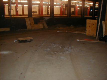
Next to the Brooklyn-bound local track is the closed Williamsburg Bridge Trolley Terminal, which was built along with the subway station and opened several months earlier. The terminal consisted of eight turning loops with low-level platforms which were used for trolley service from 1908 to 1948 that traveled over the Williamsburg Bridge to different parts of Brooklyn.[9][10][11]
The underground terminal for the subway adjacent to the trolley terminal opened on September 16, 1908. The station initially contained only two tracks which ended at the west end of the station. It also had an additional southern side platform adjacent to the trolley terminal, with the station organized in a Spanish solution.[9] The station was rebuilt for through service from 1911 to 1913 for the Centre Street Subway to extend to Chambers Street. The station's platforms originally could only fit six 67-foot-long (20 m) cars. In April 1926, the New York City Board of Transportation (BOT) received bids for the lengthening of platforms at three stations on the Centre Street Loop, including the Essex Street station, to accommodate eight-car trains.[12] The New York City Board of Estimate approved funds for the project in July 1926,[13] and the extensions were completed in 1927, bringing the length of the platforms to 535 feet (163 m).[14][15]
The rest of the subway line has four tracks while there was room at Essex Street station for only three tracks and two platforms. There is provision for a fourth track to run through the trolley terminal area and join the subway west of the trolley terminal, should a four-track subway station be wanted. For many years, the elevated train service was very intensive, but at the same time, the trolley service was also well patronized, so no expansion was ever proposed. This would have added a second side platform to the south of the southernmost track, directly against the trolley terminal. The island platform would have been demolished to make room for the fourth track; alternatively, the fourth track would have been constructed adjacent to the southernmost track, resulting in a 2 side-platform, 1 island-platformed station, similar to the IRT platforms at
After streetcar service ended in 1948, the former track area on the south side of the bridge was rebuilt into auto lanes with a new ramp from street level closing off the former downhill ramp to the trolley terminal.[16][17] The trolley terminal itself, however, was left vacant, and small portions were converted to storerooms and an emergency exit to the southern corners of Norfolk Street and Delancey Street.[18] The vacant space was the proposed location of the LowLine, a planned underground park, but after fundraising proved unsuccessful, the project was indefinitely postponed in February 2020.[19] Prior to 1913, the BMT station was also known as Delancey Street.
Image gallery
-
 Platform
 -
 Name mosaic
 -
 Letter mosaic
 -
 Abandoned trolley terminal
 -
 Abandoned trolley terminal
.JPG)


IND Sixth Avenue Line platforms
Delancey Street <F> | ||||||||||||||||||||||||||||||||||||||||||||||||||||||||||||||||||||||||||||||||||
|---|---|---|---|---|---|---|---|---|---|---|---|---|---|---|---|---|---|---|---|---|---|---|---|---|---|---|---|---|---|---|---|---|---|---|---|---|---|---|---|---|---|---|---|---|---|---|---|---|---|---|---|---|---|---|---|---|---|---|---|---|---|---|---|---|---|---|---|---|---|---|---|---|---|---|---|---|---|---|---|---|---|---|
| Platforms | 2 side platforms | |||||||||||||||||||||||||||||||||||||||||||||||||||||||||||||||||||||||||||||||||
| Tracks | 2 | |||||||||||||||||||||||||||||||||||||||||||||||||||||||||||||||||||||||||||||||||
| Other information | ||||||||||||||||||||||||||||||||||||||||||||||||||||||||||||||||||||||||||||||||||
| Opened | January 1, 1936 | |||||||||||||||||||||||||||||||||||||||||||||||||||||||||||||||||||||||||||||||||
| Accessible | not ADA-accessible; accessibility planned | |||||||||||||||||||||||||||||||||||||||||||||||||||||||||||||||||||||||||||||||||
| Opposite- direction transfer | Yes | |||||||||||||||||||||||||||||||||||||||||||||||||||||||||||||||||||||||||||||||||
| Traffic | ||||||||||||||||||||||||||||||||||||||||||||||||||||||||||||||||||||||||||||||||||
| 2023 | 7,083,681[2] | |||||||||||||||||||||||||||||||||||||||||||||||||||||||||||||||||||||||||||||||||
| Rank | 29 out of 423[2] | |||||||||||||||||||||||||||||||||||||||||||||||||||||||||||||||||||||||||||||||||
| ||||||||||||||||||||||||||||||||||||||||||||||||||||||||||||||||||||||||||||||||||
| ||||||||||||||||||||||||||||||||||||||||||||||||||||||||||||||||||||||||||||||||||
| ||||||||||||||||||||||||||||||||||||||||||||||||||||||||||||||||||||||||||||||||||
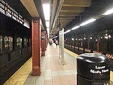
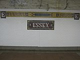
The Delancey Street station (also announced as Delancey Street–Essex Street) on the IND Sixth Avenue Line has two tracks and two side platforms. The station has a part-time booth on the south side of Delancey Street and has two street staircases. Crossovers connect both platforms to the BMT platforms, which are above and perpendicular to the IND platforms. Both platforms have a renovated medium Parma violet trim line with a black border, as well as renovated tile captions in a different font, spaced farther apart, and far lower on the wall than the originals. Only the original mosaic name tablets remain, which read "DELANCEY ST." in white sans-serif lettering on a dark Parma violet background and medium Parma violet border. The southbound platform is lined with indigo I-beam columns, while the northbound platform has tiled columns, both having the standard black station name plate with white lettering every other columns. In a departure from the norm of recent restorations, northbound platform columns that don't have the station name plate feature a large "D" composed of four tiles.
The station formerly had two mezzanine areas, split by the BMT station. Twelve staircases, six on each platform, led to the mezzanine. Most were removed; only the stairs at the extreme north end and the extreme south end of both platforms remain as stairways to emergency exits and storage space.
There are two large wall-sized pieces of artwork, one on each wall where the staircase exits and transfers are located. The artist for both glass mosaics is
The uptown platform is titled Delancey Orchard and has a cherry orchard tree mosaic, which symbolized the tree owned by the Delancey family in the 18th century. Miniature versions appear along all staircases leading from the Delancey Street platforms to either fare control.
-
 Original mosaic name tablet under renovated trim line
 -
 "D" tiles on alternating northbound platform columns
 -
 Delancey Orchard mosaic on the northbound platform
 -
 Shad Crossing mosaic on the southbound platform


Notes
- ^ wrong-way concurrencybetween the J and Z trains and the M train.
References
- ^ a b c "Glossary". Second Avenue Subway Supplemental Draft Environmental Impact Statement (SDEIS) (PDF). Vol. 1. Metropolitan Transportation Authority. March 4, 2003. pp. 1–2. Archived from the original (PDF) on February 26, 2021. Retrieved January 1, 2021.
- ^ a b c d e f "Annual Subway Ridership (2018–2023)". Metropolitan Transportation Authority. 2023. Retrieved April 20, 2024.
- ^ "Annual Subway Ridership (2018–2023)". Metropolitan Transportation Authority. 2023. Retrieved April 20, 2024.
- from the original on March 3, 2018. Retrieved June 7, 2017.
- ^ Nonko, Emily (January 2, 2018). "After 11 years, every NYC subway station finally has countdown clocks". Curbed NY. Archived from the original on March 4, 2018. Retrieved March 4, 2018.
- ^ "MTA Neighborhood Maps: Lower East Side" (PDF). Metropolitan Transportation Authority. 2015. Archived (PDF) from the original on July 24, 2015. Retrieved August 6, 2015.
- ^ "Squadron Requests Timeline For New Escalator, Elevator at Delancey Street Station". The Lo-Down : News from the Lower East Side. February 1, 2017. Archived from the original on February 3, 2019. Retrieved February 3, 2019.
- ^ The New York Times, Mayor Runs a Train Over New Bridge Archived October 3, 2013, at the Wayback Machine, September 17, 1908, page 16
- ^ a b "Underground Bridge Terminal in New York for Brooklyn Surface and "L" Lines". Street Railway Journal. 31 (15): 592–596. April 11, 1908. Retrieved October 21, 2016.
- ^ "WillB.newphoto.jpg". Archived from the original on June 25, 2010.
- ^ "Mayor Drives Trolley Car: He Inaugurates the Service Across Williamsburg Bridge Into Subway" (PDF). The New York Times. May 19, 1908. Archived (PDF) from the original on June 26, 2021. Retrieved October 21, 2016.
- ISSN 0362-4331. Retrieved May 12, 2023.
- ^ "Broadway Merchants Get Transit Report". The Standard Union. July 22, 1926. p. 4. Retrieved May 12, 2023 – via Newspapers.com.
- ISSN 0362-4331. Retrieved May 12, 2023.
- ProQuest 1113704092.
- ^ "Buses Take Over Williamsburg Run: Trolleys End Bridge Service-Old Underground Station No Longer in Use" (PDF). The New York Times. December 6, 1948. Archived from the original on May 13, 2022. Retrieved October 21, 2016.
- Newspapers.com.
- ^ "Showing Image 2159". Archived from the original on February 4, 2019. Retrieved February 3, 2019.
- ^ "The Low Line Gets Real at Essex Street Market". thelodownny.com. Archived from the original on February 21, 2014. Retrieved February 16, 2014.
External links
| External videos | |
|---|---|
Subway station:
- nycsubway.org – BMT Nassau Street Line: Essex Street
- nycsubway.org – IND 6th Avenue: Delancey Street
- Station Reporter – Delancey Street/Essex Street Complex
- MTA's Arts For Transit – Delancey Street–Essex Street
- Delancey Street and Essex Street entrance from Google Maps Street View
- Delancey Street and Norfolk Street entrance from Google Maps Street View
- IND platforms from Google Maps Street View
- Westbound BMT Platform from Google Maps Street View
- Eastbound BMT Platform from Google Maps Street View
Trolley terminal:
- Abandoned Stations – "Williamsburg Bridge Railway terminal". Joseph Brennan, Columbia University, 2001.
| Sixth Ave. Line |
| ||||||||||
|---|---|---|---|---|---|---|---|---|---|---|---|
| Nassau St. Line | |||||||||||
| |||||||||||