Burrwood, Louisiana

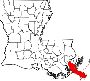
Burrwood was a community located near the far south end of the delta of the Mississippi River in Plaquemines Parish, Louisiana, United States. At one time the town had an estimated population of 1,000, but today it is uninhabited, with most of its territory fully or partially submerged by coastal erosion.
The site of this former community is located at the following coordinates: 28°58′05″N 89°22′39″W / 28.96806°N 89.37750°W[1]
History


Burrwood was established[when?] and maintained by the Army Corps of Engineers on Southwest Pass of the Mississippi River to serve as a base for dredging operations, jetty work, and other activities required to maintain navigable conditions along this channel.
Later, during
In 1942, the U.S. Army created pieces of heavy artillery (mobile
Between 1942 and 1965, Burrwood was a United States Weather Bureau and Hurricane Warning Office.[2] There were a row of officer houses for the families, a barracks complex for the unmarried men and a two-room school house for the children of the people who manned the station, as well as local fishermen who lived nearby.
References
- ^ "Burrwood (historical) Map". United States Google Satellite Maps. Retrieved June 26, 2011.
- ^ National Weather Service Office, Lincoln, Illinois. "Weather Bureau/National Weather Service History in Louisiana" (PDF). National Oceanic and Atmospheric Administration. Retrieved November 18, 2022.
{{cite web}}: CS1 maint: multiple names: authors list (link)

