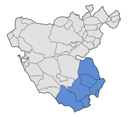
Campo de Gibraltar
Campo de Gibraltar | |
|---|---|
|
Latin for 'United by geography, history, and will') | |
 | |
| Country | |
| Autonomous community | |
| Province | |
| Municipalities | List
|
| Area | |
| • Total | 1,527.5 km2 (589.8 sq mi) |
| Population (2018) UTC+2 (CEST) | |
| Largest municipality | Algeciras |
Campo de Gibraltar (Spanish pronunciation: .

Its name comes from the
San Roque, Los Barrios and La Línea de la Concepción. Following the capture of Gibraltar during the War of the Spanish Succession the former inhabitants settled nearby creating Algeciras, San Roque, and Los Barrios. In 1759, each of them was established as a different municipality.[2]
The Campo de Gibraltar comarca is composed of the following seven municipalities:
| Municipality | Area (km2) |
Population 2018[3] |
Location |
|---|---|---|---|
| Algeciras | 85.8 | 121,414 | Bay of Gibraltar |
| La Línea de la Concepción | 19.3 | 62,940 | Mediterranean coast
|
San Roque |
146.9 | 30,472 | Interior - Mediterranean coast
|
| Los Barrios | 331.3 | 23,513 | Interior Los Alcornocales Natural Park Bay of Gibraltar |
| Castellar de la Frontera | 178.8 | 3,013 | Interior Los Alcornocales Natural Park |
| Jimena de la Frontera | 345.7 | 9,773 | Interior Los Alcornocales Natural Park |
| Tarifa | 419.7 | 18,169 | Atlantic coast Los Alcornocales Natural Park |
| Total | 1,527.5 | 269,294 |
References
- ^ Estimate at 1 January 2018: Instituto Nacional de Estadística, Madrid.
- ^ Álvarez Vázquez, Manuel (April 2004). "La pérdida de Gibraltar y el nacimiento de la nueva población de Los Barrios" (PDF). Almoraima. Revista de Estudios Campogibraltareños (34): 51–66. Archived from the original (PDF) on 20 February 2009.
- ^ Estimate at 1 January 2018: Instituto Nacional de Estadística, Madrid.
External links
36°08′N 5°27′W / 36.133°N 5.450°W
