
Canal de la Bruche
| Canal de la Bruche | |
|---|---|
Vauban | |
| Construction began | 1682 |
| Date closed | 1957 |
| Geography | |
| Start point | Soultz-les-Bains |
| End point | Strasbourg |
| Connects to | River Ill |
The Canal de la Bruche is a
Vauban, principally to transport sandstone from the quarries of Soultz for use in the construction of the fortifications of Strasbourg. The last commercial load was carried in 1939 and the canal formally closed in 1957, after bridges damaged during World War II were rebuilt with insufficient headroom for navigation.[1][2][3]
The canal is 20 kilometres (12 mi) long and has 11
Although no longer navigable, the canal is retained in water, and is now managed by the
Gallery
-
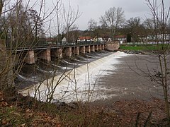 The dam on the River Bruche that feeds the canal
 -
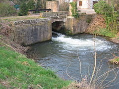 The head of the canal
 -
 Canal and restaurant
 -
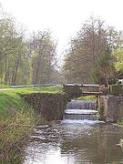 A disused lock on the canal


See also
References
Wikimedia Commons has media related to Canal de la Bruche.
- ^ ISBN 978-1-57409-087-1.
- ^ a b c "La gestion du Canal de la Bruche" [The management of the Canal Bruche] (in French). Conseil Départemental du Bas-Rhin. Archived from the original on 16 September 2015. Retrieved 16 September 2015.
- ^ a b "Cycling in Alsace - Along the river Bruche and its canal" (PDF). Tourisme Alsace. Archived (PDF) from the original on 16 September 2015. Retrieved 16 September 2015.
| International | |
|---|---|
| Geographic | |
| Other | |