
Carrière des Nerviens Regional Nature Reserve
| Carrière des Nerviens Regional Nature Reserve | |
|---|---|
IUCN category IV (habitat/species management area) | |
.jpg) | |
 Carrière des Nerviens Reserve Location in France | |
| Location | Bavay, Nord-Pas-de-Calais |
| Coordinates | 50°17′54″N 3°46′35″E / 50.29833°N 3.77639°E |
| Area | 3.11 hectares (7.7 acres; 0.0120 sq mi) |
| Created | May 25, 2009 |
| Operator | CPIE Bocage de l'Avesnois |
The Carrière des Nerviens Regional Nature Reserve (in French Réserve naturelle régionale de la carrière des Nerviens) is a protected area in the Nord-Pas-de-Calais region of northern France. It was established on 25 May 2009 to protect a site containing rare plants and covers just over 3 hectares (7.4 acres). It is located in the municipalities of Bavay and Saint-Waast in the Nord department.
The reserve was created to protect fifteen plants of regional interest and three plant communities listed in the Habitats Directive. Its flora are linked to calcium present in marl. It is located in a transition zone between the oceanic and semi-continental climates and that gives increased biodiversity, with typical species of the atlantic areas and others more continental. The reserve also plays a role in a wildlife corridor.
The site consists of an old quarry of
Geography
Location

The Carrière des Nerviens Regional Nature Reserve is located in the Arrondissement of Avesnes-sur-Helpe between the cities of Valenciennes and Maubeuge, in the Nord department, Nord-Pas-de-Calais region. It is 1 kilometre (0.62 mi) west of downtown Bavay and 1,700 metres (5,600 ft) south-east of Saint-Waast.
The reserve is triangular in shape. It is bordered to the south by the 942 main road, north-east by an unused railtrack, and to the west by a small path known as Chemin de Rametz. It covers 3.11 hectares (7.7 acres).[1][Note 1] CPIE Bocage de l'Avesnois owns a parcel of land on the other side of the railtrack. Though not yet included in the reserve, it is expected to be added when the current agreement is renewed.[2]
Relief
The reserve is located in the valley of the stream Ruisseau de Bavay, with an elevation of between 110 and 115 metres (361 and 377 ft). It has an overall north-south gradient of −5 metres (−16 ft). A mound of accumulated debris, which rises to about 6 metres (20 ft) above the path Chemin de Rametz, is located north-west of the site. After quarrying operations ceased, the quarry was filled mainly with the marl of the Bellignies quarry.[3] The area has since been completely recolonized by vegetation through ecological succession.
Hydrology
The reserve is located in the valley of the Ruisseau de Bavay, a tributary of the Hogneau, and is part of the greater drainage basin of the Scheldt. The reserve is not in direct contact with the river. It is supplied with water only by precipitation, which is retained by the natural properties of marl.[3]
Climate
The reserve's nearest weather station is at Cambrai, about 42 kilometres away, inland, to the southeast. However, the nature reserve is affected by the nearby presence of the Ardennes Mountains, which gives a continental influence to the climate.
The regular precipitation and the absence of drought,[4] as well as the predominance of south-southwest winds and rain vectors,[5] show the influence of oceanic climate. However, some significant rainfall variability between seasons,[4] the moderate temperature range, and the high proportion (69.8 percent) of low winds (less than 4 metres per second (13 ft/s)) compared to strong winds (3.2 percent over 8 metres per second (26 ft/s)) winds[5] are typical of a continental influence. This combination is atypical of an altered oceanic climate, a transition zone between the oceanic and semi-continental climates, characterized by mild winters and cool summers.[6]
In the reserve, this climatic transition leads to increased biodiversity. For example, common bluebell (Hyacinthoides non-scripta) is a typical species of the Atlantic areas,[7] while the common butterbur (Petasites hybridus) is more continental.[8]
History

Quarry
The site is a former quarry, used for its sandstone deposits as early as the late nineteenth century.[Note 2] by the Chevallier & Cie company, which employed about 70 workers, including 25 miners.[11] In 1909, the annual production was 12,000 cubic metres (420,000 cu ft) of macadam, 500 cubic metres (18,000 cu ft) of ballast and 25,000 cubic metres (880,000 cu ft) of cobblestones.[12]
Quarrying ceased in the early 1960s (1962–1965), when the stones extracted were no longer of sufficient quality. Between 1971 and 1978, the quarry was gradually filled with marl from the Bellignies quarry. Since then, the site has been completely recolonized by vegetation through ecological succession, forming tree, shrub and herb layers.
Reserve

In 2001, the site was brought to the attention of the
The name of the reserve recalls the former industrial activity (Carrière: quarry) and the Gallo-Roman history of Bavay, the capital city of the ancient Nervii tribe.[17]
In 2015, another owner give the management of his parcel.
Geology
The Paleozoic folded outcrops of the Bavay-Saint-Waast area are the bedrock of the eastern flank of the Mélantois' anticline, where the transgressive Cretaceous (Turonian and Cenomanian chalk) thins, and may eventually disappear by erosion. Strata of Hercynian basement, raised in the East by an important structural horst-type accident, then appear locally. In these Paleozoic strata, the Devonian presents as a sandstone base of the Lower Famennian, where the levels were quarried[18][Note 5]
Formations
Quarried level
The stone that was quarried is
's content.At the base of the deposit, these sandstones are reddish brown, very
Lower level
Under the Famennian, the Frasnian consists, from top to bottom, of nodular gray shale, and mica rich in fossils such as
Upper levels
Those Famennian strata represent the top of the Paleozoic series pleated with north dipping. Above, the transgressive Upper Cretaceous overlies horizontally with unconformity. It includes from the bottom to the top a paleozoic boulder conglomerate mixed with a sandy and glauconitic marl matrix, coarse clayey and glauconitic sands, containing Chlamys asper, Ostrea diluviana, Praeactinocamax plenus and finally marl with Terebratulina gracilis. These strata belong to the Cenomanian-Turonian and were deposited between 90 and 100 million years ago,[27] during a transgressive phase.[28]
Fifty million years ago, during the
This stratum is covered with
Nature of the embankments

The stones used to backfill the quarry are those which underlie the Givetian limestone extracted in the Bellignies quarry. There is Sarrasin de Bettrechies, a coarse shelly limestone, deep gray, yellowish when it outcrops, detrital ferruginous dated to the Lower Cenomanian epoch, a hundred million years ago. There is clay and very glauconitic marl of the Upper Cenomanian stage, enriched by a pebble conglomerate paléozoïc stones. These rocks contain Praeactinocamax plenus, Chlamys asper, Ostrea diluviana and radiated fossils: Janira quadricostata, Cyprina ligeriensis, Arca mailleana. There is also bluish marl of the Turonian.[31][32]
Ecology
Plant communities

The site is characterized by a mosaic of 17
-
 Common butterbur
 -
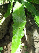 hart's-tongue fern
 -
 narrow-leaved everlasting-pea


Flora
Vascular plants
The reserve has 171 plant species, and 15 of them have heritage interest.[39][Note 8]
Twelve of them were inventoried in 2003,
Seven plants are protected by a regional scale: common spotted orchid, man orchid, bee orchid, zigzag clover, liquorice milkvetch, narrow-leaved everlasting-pea and wood forget-me-not.[52]
-
 Lizard orchid
 -
 Wood forget-me-not
 -

-
 Liquorice milkvetch


Mosses
In 2012, 43 species of
Mushrooms
Among the 115 species recorded in 2004 on the site,
-
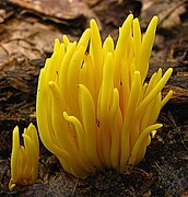 Golden spindles
 -
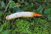 Dog stinkhorn
 -
 Gray shag
 -

-
 Burnt knight
_Corner_95377_cropped.jpg)


Fauna
Mammals
Common mammals found here include the


Birds
Forty-two species of birds have been observed on the site, 25 of which are


Reptiles and amphibians
The
-

-

-

-
 Slowworm


Invertebrates
Reproduction of
Twenty-three species of butterflies and 105 species of moth enjoy the floral diversity of the site.[63] The holly blue (Celastrina argiolus) is a heritage species.[41]
Of the nine species of
-

-
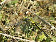 Western clubtail
 -
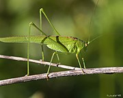 Sickle-bearing bush cricket
 -
 Long-horned groundhopper


-fr.svg)
The wildlife corridor
To the north are present two sites containing a rich biodiversity: the Natura 2000 Belgian area "Hauts-Pays des Honnelles" and a ZNIEFF[Note 13] "Vallée de l’Hogneau et ses versants et les ruisseaux d’Heugnies et de Bavay". The Bellignies quarry with embankments similar to those which filled "Carrière des Nerviens" is therefore under similar ecological conditions. In the south, the Forêt de Mormal is a major area for biodiversity covered by ZNIEFF and Natura 2000 sites. The railway, unused recently and the stream Ruisseau de Bavay then the river Hogneau provide connection.
Threats and responses
In the past, the site was threatened by garbage dumps or by passage of 4x4 vehicles or quads. The installation of gates by the municipality of Bavay solved the problem.[64] Pedestrians rarely venture off the path. The anthropization is limited. The greatest threats to the species are primary succession[37] and invasive plants.[65]
Primary succession
The marls was colonized by pioneer species, then shrubs and trees, corresponding to a primary succession. Without human intervention, a climax community would be reached. This dynamic may eventually lead to the disappearance of related open environments, particularly heritage species. However woodlands can also play an important role in creating habitat for many species. The management plan is therefore to maintain patch dynamics.[65]

Invasive species
Four invasive species are a problem in the reserve.
Many extensive areas of
The
Finally,
-
 Wood small-reed
 -
 Japanese knotweed
 -
 Bramble
 -
 Canada golden-rod


Management
Protection
Parcels of land owned by the CPIE Bocage de l'Avesnois were classified as a regional nature reserve on 25 May 2009 by decision of the Conseil Régional Nord-Pas-de-Calais.[1] The entire site is included in a ZNIEFF type 1[Note 14] Château de Rametz (carrière des Nerviens) and another of type 2[Note 15] Complexe écologique de la forêt de Mormal et des zones bocagères associées.
Management objectives

The second version of the environmental management scheme covers the period 2007–2012. It presents the knowledge, management, monitoring and vulgarization objectives.[42]
The preservation of the existing diversity was the most important goal.
The education, interpretation and promotion of local heritage missions should also be continued,[75] while the fauna knowledge was to be developed and floristic monitoring provided.[76]
-
 Man orchid
 -
 Round-leaved wintergreen
 -
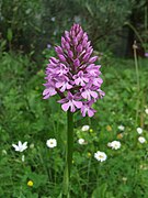 Pyramidal orchid
 -
 Common spotted orchid
.jpg)


.jpg)
Assessment of the activities
Evaluation is in progress. However, a partial analysis is already underway.[77]
Activities carried out
The Bavay's municipality has erected two barriers to prohibit access to motorized vehicles.[78] Volunteers and employees of the CPIE Bocage de l'Avesnois manage the site regularly.[79]
Management of the diversity
Manual removal of the


From 2007 to 2012, the number of
On this site, 171 plant species are surveyed. Given its size and poor soil, this diversity is notable.[84] Management undertaken in recent years has been essential to maintaining open areas, the most threatened by primary succession. Thus, the various vegetation layers (pioneer and mature woodland, bushy areas, open areas) provide a mosaic of habitats, and thus remarkable species.[85]
Improved knowledge of flora and fauna
Besides heritage plants monitoring, an additional inventory of
Education, interpretation and promotion of local heritage

New opportunities
Interreg micro projects, established in February 2012, resulted in methodological exchanges on the management of reserves between two Belgian associations Réserves naturelles et ornithologiques de Belgique and Natagora.[89]
A new environmental management scheme is now under consideration.[90]
Bibliography
Studies of the reserve
The following documents are available from the operator: CPIE Bocage de l'Avesnois.
- CPIE Bocage de l'Avesnois (2007). Plan de gestion 2007–2012 de la réserve naturelle régionale de la carrière des Nerviens [Carrière des Nerviens Regional Nature Reserve Environmental Management Scheme 2007–2012] (in French). Gussignies: CPIE Bocage de l'Avesnois. p. 141.
- Haouat, Safia (2013). Proposition d'évaluation du plan de gestion 2008–2012 de la Réserve Naturelle Régionale de la carrière des Nerviens dans le cadre du renouvellement de son plan de gestion [Assessment proposal of Carrière des Nerviens Regional Nature Reserve Environmental Management Scheme 2008–2012 in the context of its renewal] (in French). Gussignies: CPIE Bocage de l'Avesnois. p. 107.
- Bissey, Virginie (2003). Plan de gestion 2003–2007 de la future réserve naturelle régionale de Rametz [Rametz future Regional Nature Reserve Environmental Management Scheme 2003–2007] (in French). Gussignies: Nord Nature Bavaisis.
- Julve, Philippe (2003). Étude de la flore et de la végétation de l'ancienne carrière de Rametz [Study of flora and vegetation of the old Rametz quarry] (in French). Gussignies: Nord Nature Bavaisis. p. 23.
- Lecron, Jean-Michel (2013). Inventaire des Bryophytes de la Réserve naturelle régionale de la Carrière des Nerviens [Inventory of Bryophytes of the Carrière des Nerviens Regional Nature Reserve] (in French). Bailleul: Conservatoire Botanique National de Bailleul.
- Lecuru, Christophe; Courtecuisse, Régis (2004). Rapport d'étude mycologique (inventaire et évaluation patrimoniale) sur le bois d'Encade (Gussignies) et la carrière de Rametz [Mycology study report (inventory and heritage evaluation) in the bois d'Encade (Gussignies) and Rametz quarry] (in French). Lille: A.R.U.M. (Association de Recherches Universitaires Multi-disciplinaires), Département de Botanique.
History of quarry and geology
- Association française pour l'avancement des sciences (1909). Lille et la région du nord en 1909 [Lille and the northern region in 1909] (in French). Lille: imp. I. Danel. p. XIII, 1061. Archived from the original on 12 October 2013. Retrieved 20 August 2013.
- Boulvain, Frédéric; Pingot, Jean-Louis (2011). Genèse du sous-sol de la Wallonie [Genesis of the Wallonia subsoil] (PDF). Bruxelles: Académie royale de Belgique. p. 190. ISBN 978-2-8031-0288-4. Retrieved 27 August 2013.
- Bureau de Recherches Géologiques et Minières (1972). Carte géologique à 1/50000: Le Quesnoy [Geologic card to 1/50000: Le Quesnoy] (PDF) (in French). Bureau de Recherches Géologiques et Minières. p. 19. Retrieved 24 August 2013.
- Bureau de Recherches Géologiques et Minières (2013). "Géologie en Nord-Pas de Calais" [Geology in Nord-Pas-de-Calais] (in French). Retrieved 23 August 2013.
- Copper, Paul (2002). "Silurian and devonian reefs: 80 million years of global greenhouse between two ice ages". Phanerozoic Reef Patterns. 72: 181–238. ISBN 1-56576-081-6. Retrieved 24 August 2013.
- Cornet, Jules (1899). "Compte-rendu de la session extraordinaire de la société géologique de Belgique tenue à Mons du 26 au 27 septembre 1899" [Record of the extraordinary session of the Geologic Society of Belgium held in Mons from 26 to 27 September 1899]. Annales de la société géologique de Belgique (in French). 26. Société géologique de Belgique: CCCVI, 177, 41, XXVIII. Retrieved 24 August 2013.
- Ladrière, Jules (5 November 1879). "Documents nouveaux pour l'étude du terrain dévonien des environs de Bavay" [New documents for the study of Devonian near Bavay]. Annales de la Société géologique du Nord (in French). VII. Société géologique du Nord: 1–11. Retrieved 18 August 2013.
- Ladrière, Jules (4 May 1881). "Etude géologique sur les tranchées du chemin de fer du Quesnoy à Dour" [Geologic study on the railway trenches of the line Le Quesnoy-Dour]. Annales de la Société géologique du Nord (in French). XIII. Société géologique du Nord: 135–176. Retrieved 18 August 2013.
- Ladrière, Jules (September 1905). "Les affleurements du Terrain Dévonien dans les environs de Bavai" [Devonian outcrops near Bavai]. Annales de la Société géologique du Nord (in French). XXXIV. Société géologique du Nord: 205–264. Retrieved 24 August 2013.
- National Stratigraphic Commission Belgium (2013). "Famennian Lithostratigraphic Units". Archived from the original on 12 October 2013. Retrieved 25 August 2013.
- Van Bellingen, Luc (2013). "Géologie du Dévonien" [Devonian geology] (in French). Archived from the original on 12 October 2013. Retrieved 24 August 2013.
- Van Bellingen, Luc (2013). "Le Famennien" [Famennian] (in French). Retrieved 24 August 2013.
Ecology and management
- Duhamel, Françoise; Catteau, Emmanuel (2010). "Inventaire des végétations de la région Nord-Pas de Calais: Partie 1. Analyse synsystématique. Évaluation patrimoniale (influence anthropique, raretés, menaces et statuts). Liste des végétations disparues ou menacées" [Inventory of the vegetations of the Nord-Pas-de-Calais region: Part 1. Synsytematic analysis. Heritage assessment (anthropogenic influence, rarities, threats and statutes). List of extirpated or threatened vegetations.] (PDF). Bulletin de la Société de Botanique du Nord de la France. 63 (1). Centre régional de phytosociologie agréé Conservatoire botanique national de Bailleul, avec la collaboration du collectif phytosociologique interrégional: 1–83. Archived from the original (PDF) on 12 October 2013. Retrieved 23 August 2013.
- European commission (April 2013). "Interpretation Manual of European Union Habitats:EUR 28" (PDF). Retrieved 20 August 2013.
- GON, SfO et CFR (2012). "Liste rouge régionale – Nord – Pas-de-Calais: Les Odonates du Nord–Pas-de-Calais" [Nord-Pas-de-Calais red regional list: Odonata of the Nord-Pas-de-Calais] (PDF) (in French). Retrieved 24 August 2013.
- INPN (2013). "ZNIEFF 310030028 - Château de Rametz (carrière des Nerviens): Commentaires" [ZNIEFF 310030028 - Château de Rametz (carrière des Nerviens): Comments] (in French). Retrieved 22 August 2013.
- INPN (2013). "ZNIEFF 310030028 - Château de Rametz (carrière des Nerviens): Espèces" [ZNIEFF 310030028 - Château de Rametz (carrière des Nerviens): Species] (in French). Retrieved 22 August 2013.
- Lecron, Jean-Michel; Hauguel, Jean-Christophe (May 2013). Toussaint, Benoît (ed.). Inventaire des Bryophytes du Nord-Pas de Calais: statuts, rareté et menace [Inventory of the Bryophytes of Nord-Pas-de-Calais: statutes, rarities and threats] (in French) (1a ed.). Bailleul: Centre régional de phytosociologie agréé Conservatoire botanique national de Bailleul, avec la collaboration du Collectif des Bryologues du Nord-Ouest de la France. Archived from the original on 2013-10-12. Retrieved 2013-08-24.
- Muller, Serge, ed. (2004). Plantes invasives en France: État des connaissances et propositions d'actions [Invasive Plants in France: states of knowledge and action proposals]. Patrimoines naturels (in French). Vol. 62. Paris: Muséum national d'Histoire naturelle. p. 168. ISBN 978-2-85653-570-7.
- République française (1991). "Arrêté du 1 avril 1991 relatif à la liste des espèces végétales protégées en région Nord - Pas-de-Calais complétant la liste nationale" [Order of 1 April 1991 relating to the list of protected plants in Nord-Pas-de-Calais region completing the national list] (in French). Retrieved 19 August 2013.
- Rhind, Peter Martin (2010). "Atlantic European Ecosystems". Retrieved 20 August 2013.
- Toussaint, Benoît, ed. (2011). Inventaire de la flore vasculaire du Nord-Pas de Calais (Ptéridophytes et Spermatophytes): raretés, protections, menaces et statuts [Inventory of the vascular flora of the Nord-Pas de Calais (Pteridophyta and Spermatophyta): rarities, protection, threats and status] (PDF) (in French) (4b ed.). Bailleul: Centre régional de phytosociologie agréé Conservatoire botanique national de Bailleul, avec la collaboration du Collectif botanique du Nord-Pas de Calais. pp. I–XX, 1–62. Archived from the original (PDF) on 2013-10-07. Retrieved 24 August 2013.
- Swinnen, Vincent (2012). "Première collaboration transfrontalière pour notre Régionale !" [First cross-border cooperation for our regional] (PDF). Echo des Marais (in French) (79). Natagora: 12. Archived from the original (PDF) on 12 October 2013. Retrieved 24 August 2013.
- La Voix du Nord (17 September 2010). "Chantier nature demain avec le CPIE" [Nature management tomorrow with CPIE] (in French). Retrieved 24 August 2013.
Other references
- Bromwich, James (2013). The Roman Remains of Northern and Eastern France: A Guidebook. Routledge. p. 480. ISBN 9780415139946. Retrieved 20 August 2013.
- Conseil Régional Nord-Pas-de-Calais (25 May 2009). "Délibération de création de la réserve" [Deliberation of the creation of the reserve] (PDF) (in French). Retrieved 20 August 2013.[permanent dead link]
- Réserves naturelles de France (2012). "Carrière des Nerviens" (in French). Retrieved 19 August 2013.
Notes and references
Notes
- ^ The Carrière des Nerviens's site is 4.5 hectares (11 acres). But only the property of the CPIE Bocage de l'Avesnois is classified of the regional nature reserve; the parcels belonging to other owners were not classified.
- ^ The activity is already attested in 1881: "À 100 mètres du pont du chemin de fer, dans une prairie située en face de l'usine de M. Levent, on exploite les psammites du Condros (...)".[9] However, it seems to be later than 1879 because the same author then wrote: "Le dernier affleurement de psammites visible le long du ruisseau de Bavai, se trouve dans une grande prairie en face de l'usine de M. Levent."[10]
- ^ The Association française pour l'avancement des sciences wrote that in the Bavay quarry ""Le travail est le même qu'à Watissart et les matériaux extraits sont identiques et classés de la même façon",[11] the work is the same and extracted materials are identical and classified in the same way as at the Watissart quarry located in Jeumont.[13]
- ^ In France, an environmental management scheme is defined by the Code de l'environnement (article R332-43). A scientific council must validate it to obtain or maintain the accreditation.
- ^ These quarried rocks are no longer visible on the site, as they were fully covered by embankments.
- ^ Some geologists also call those sandstones psammite
- ^ The ecological units have been classified by Phytosociology.
- ^ The heritage value of the plants is defined by the inventory of the vascular flora of the Nord-Pas de Calais[40]
- lizard orchid(Himantoglossum hircinum) has not been seen in the reserve since 2003.
- ISSN 0181-1584
- ^ Trichoglossum hirsutum is vulnerable in the Regional Red List. This species likes moist and mossy grassy places.
- ^ Hebeloma clavulipes was identified for the first time in the Nord-Pas-de-Calais region. It was therefore not included in the Red List of 1997. It is an extomycorhizic species of willows in the reserve.
- ^ ZNIEFF is an acronym for Zone Naturelle d'Intérêt Écologique, Faunistique et Floristique, natural area of ecological, faunal and floral interest. The designation of a ZNIEFF is essentially based on the presence of species or groups of species with high heritage value
- ^ ZNIEFF type 1, of small size, are environmentally homogeneous spaces and have at least one species and / or rare or threatened habitat of local and regional, national or community interest, or they are spaces of great interest in the functioning of the local ecology.
- ^ ZNIEFF type 2 are very rich natural sets, or slightly modified, which provide important biological potential. They may include ZNIEFF type 1 and have a functional role and an ecological and landscape coherence.
References
 Media from Commons
 Travel information from Wikivoyage
- ^ a b Réserves naturelles de France 2012
- ^ Haouat 2013, p. 19
- ^ a b CPIE Bocage de l'Avesnois 2007, p. 27
- ^ a b CPIE Bocage de l'Avesnois 2007, p. 18
- ^ a b CPIE Bocage de l'Avesnois 2007, p. 21
- ^ CPIE Bocage de l'Avesnois 2007, p. 22
- ^ Rhind 2010
- ^ a b European Commission 2013, p. 78
- ^ a b c Ladrière 1881, p. 154
- ^ a b Ladrière 1879, p. 9.
- ^ a b Association française pour l'avancement des sciences 1909, p. 280
- ^ Association française pour l'avancement des sciences 1909, p. 281
- ^ Association française pour l'avancement des sciences 1909, pp. 277–280
- ^ CPIE Bocage de l'Avesnois 2007, p. 12
- ^ Bissey 2003
- ^ Conseil Régional Nord-Pas-de-Calais 2009
- ^ Bromwich 2013, p. 39
- ^ Bureau de Recherches Géologiques et Minières 2013
- ^ a b Boulvain & Pingot 2011, p. 72
- ^ Copper 2010
- ^ Luc Van Bellingen 2013
- ^ Bureau de Recherches Géologiques et Minières 1972, p. 8
- ^ National Stratigraphic Commission Belgium 2013
- ^ Luc Van Bellingen 2013
- ^ Bureau de Recherches Géologiques et Minières 1972, pp. 8–9
- ^ Ladrière 1905, p. 260
- ^ Bureau de Recherches Géologiques et Minières 1972, pp. 3–4
- ^ Boulvain & Pingot 2011, pp. 125–126
- ^ Bureau de Recherches Géologiques et Minières 1972, p. 3
- ^ a b Bureau de Recherches Géologiques et Minières 1972, p. 2
- ^ Cornet 1899, pp. CCXI–CCXII
- ^ Bureau de Recherches Géologiques et Minières 1972, p. 4
- ^ Julve 2003
- ^ European Commission 2013, p. 96
- ^ Duhamel & Catteau 2010, p. 50
- ^ Duhamel & Catteau 2010, p. 56
- ^ a b c d INPN 2013
- ^ Duhamel & Catteau 2010, p. 70
- ^ Haouat 2013, p. 35
- ^ Toussaint 2011
- ^ a b INPN 2013
- ^ a b CPIE Bocage de l'Avesnois 2007, pp. 92–104
- ^ CPIE Bocage de l'Avesnois 2007, p. 33
- ^ CPIE Bocage de l'Avesnois 2007, p. 32
- ^ CPIE Bocage de l'Avesnois 2007, p. 58
- ^ CPIE Bocage de l'Avesnois 2007, p. 60
- ^ CPIE Bocage de l'Avesnois 2007, p. 62
- ^ CPIE Bocage de l'Avesnois 2007, p. 55
- ^ CPIE Bocage de l'Avesnois 2007, p. 68
- ^ CPIE Bocage de l'Avesnois 2007, p. 66
- ^ CPIE Bocage de l'Avesnois 2007, p. 45
- ^ République française 1991
- ^ Lecron 2013
- ^ Lecron, Toussaint & Hauguel 2013
- ^ Lecuru & Courtecuisse 2004
- ^ CPIE Bocage de l'Avesnois 2007, p. 71
- ^ a b c CPIE Bocage de l'Avesnois 2007, p. 75
- ^ CPIE Bocage de l'Avesnois 2007, p. 73
- ^ CPIE Bocage de l'Avesnois 2007, p. 38
- ^ Haouat 2013, p. 39
- ^ GON, SfO et CFR 2012
- ^ Haouat 2013, p. 40
- ^ CPIE Bocage de l'Avesnois 2007, p. 39
- ^ CPIE Bocage de l'Avesnois 2007, p. 79
- ^ a b CPIE Bocage de l'Avesnois 2007, p. 83
- ^ CPIE Bocage de l'Avesnois 2007, p. 95
- ^ a b c CPIE Bocage de l'Avesnois 2007, p. 96
- ^ a b c Haouat 2013, p. 52
- ^ Muller 2004, pp. 34–37
- ^ CPIE Bocage de l'Avesnois 2007, p. 80
- ^ CPIE Bocage de l'Avesnois 2007, p. 92
- ^ CPIE Bocage de l'Avesnois 2007, p. 93
- ^ CPIE Bocage de l'Avesnois 2007, p. 94
- ^ CPIE Bocage de l'Avesnois 2007, pp. 95–96
- ^ CPIE Bocage de l'Avesnois 2007, pp. 97–99
- ^ CPIE Bocage de l'Avesnois 2007, pp. 99–100
- ^ Haouat 2013, pp. 46–75
- ^ Haouat 2013, p. 55
- ^ Haouat 2013, p. 59
- ^ Haouat 2013, p. 67
- ^ Haouat 2013, p. 68
- ^ Haouat 2013, p. 72
- ^ Haouat 2013, pp. 72–73
- ^ a b Haouat 2013, p. 80
- ^ Haouat 2013, pp. 80–81
- ^ Haouat 2013, p. 74
- ^ La Voix du Nord 2010
- ^ Haouat 2013, p. 57
- ^ Swinnen 2012, pp. 4–5
- ^ Haouat 2013