
Casa Grande Peak
| Casa Grande Peak | |
|---|---|
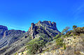
 East aspect | |
| Highest point | |
| Elevation | 7,325 ft (2,233 m)[1][2] |
| Prominence | 585 ft (178 m)[2] |
| Parent peak | Toll Mountain (7,415 ft)[2] |
| Isolation | 0.93 mi (1.50 km)[2] |
| Coordinates | 29°16′04″N 103°17′14″W / 29.2676582°N 103.2873267°W[3] |
| Geography | |
 Casa Grande Peak Location of Casa Grande Peak in Texas  Casa Grande Peak Casa Grande Peak (the United States) | |
| Country | United States |
| State | class 2[2] Southwest slope |
Casa Grande Peak is a 7,325-foot-elevation (2,233-meter) mountain summit in Brewster County, Texas, United States.
Description
Casa Grande Peak is located in
hot arid climate zone with hot summers and mild winters.[6] Any scant precipitation runoff from the mountain's slopes drains into the Rio Grande watershed and the lower slopes of the peak are covered by juniper, oak, and piñon. "Casa Grande" is Spanish for "big house." The mountain is so named because it resembles a large castle, and the toponym was officially adopted in 1939 by the United States Board on Geographic Names.[3]
See also
Gallery
-
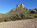
 Casa Grande Peak viewed from Chisos Basin Visitors Center
 -

-
-
 Northwest aspect


References
- ISBN 9781493063123, p. 55.
- ^ a b c d e f "Casa Grande Peak - 7,325' TX". listsofjohn.com. Retrieved 2024-01-23.
- ^ a b "Casa Grande Peak". Geographic Names Information System. United States Geological Survey, United States Department of the Interior. Retrieved 2024-01-23.
- ^ a b c "Casa Grande Peak, Texas". Peakbagger.com. Retrieved 2024-01-23.
- ^ Scientific Investigations Map 3142, United States Geological Survey, 2010.
- ISSN 1027-5606.
External links
Wikimedia Commons has media related to Casa Grande (Texas).
- Casa Grande Peak: Weather forecast
Places adjacent to Casa Grande Peak | ||||||||||||||||
|---|---|---|---|---|---|---|---|---|---|---|---|---|---|---|---|---|
| ||||||||||||||||