
Castelbelforte
Castelbelforte | |
|---|---|
| Comune di Castelbelforte | |
 | |
Location of Castelbelforte  | |
UTC+2 (CEST) | |
| Postal code | 46032 |
| Dialing code | 0376 |
Castelbelforte (
Mantovano: I Castei) is a comune (municipality) in the Province of Mantua in the Italian region Lombardy, located about 140 kilometres (87 mi) east of Milan and about 9 kilometres (6 mi) northeast of Mantua. As of 31 December 2004[update], it had a population of 2,636 and an area of 22.3 square kilometres (8.6 sq mi).[3]
Castelbelforte borders the following municipalities:
San Giorgio di Mantova, Sorgà, Trevenzuolo
.
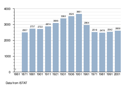
Demographic evolution
References
- ^ "Superficie di Comuni Province e Regioni italiane al 9 ottobre 2011". Italian National Institute of Statistics. Retrieved 16 March 2019.
- ^ "Popolazione Residente al 1° Gennaio 2018". Italian National Institute of Statistics. Retrieved 16 March 2019.
- Istituto Nazionale di Statistica(Istat).
This article on a location in the Province of Mantua is a stub. You can help Wikipedia by expanding it. |