
Central Business District (Miami)
Central Business District of Miami
Downtown Miami | |
|---|---|
Neighborhood of Miami | |
 | |
 | |
| Country | United States |
| State | Florida |
| County | Miami-Dade County |
| City | Miami |
| Time zone | EST |
The Central Business District (CBD) of
city center of what has become Greater Downtown Miami[1] in Florida. Over 92,000 people work in Miami's Central Business District.[2]
The Central Business District is generally bound by
financial district, which neighbors Brickell
to the south.
The Central Business District of Miami has over 5,000,000 square feet (460,000 m2) of office space, including more than fifteen buildings with greater than 100,000 sq ft (9,300 m2) of floor space.[4]
History
.jpg)

The City of Miami was officially incorporated as a city on July 28, 1896, with a population of just over 300.Julia Tuttle Causeway, crossing Biscayne Bay just north of Downtown in Edgewater, is named in honor of Tuttle.
Character

The CBD has long been
Miami-Dade College is located in the CBD, with about ten buildings around NE 5 Street and NE 2 Ave. The historic Flagler Street, which is the north–south divider of the street grid in Miami-Dade, may undergo a major renovation from the Miami River to the terminus at Biscayne Boulevard starting by 2016. The project was publicized in 2014 and has faced several delays.[6]
Transportation
The
ridesharing companies, and shared scooters. Downtown Miami as defined by Walk Score which includes Brickell and the Arts & Entertainment District, is considered "very walkable" and as having "world-class public transportation", as well as being "very bikeable".[7]
Gallery
- Late 19th thru 20th centuries
-
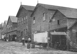 Miami Avenue in 1896, when approximately 400 men voted to incorporate Miami as a city
 -
 Crowds on Flagler Street in Downtown Miami on August 15, 1945, 20 minutes after the announcement of Japan's surrender at the end of World War II


- Since 2000
-
 View of downtown over Biscayne Bay with larger buildings marked.
 -
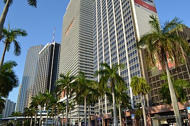
 View of downtown skyscrapers from Bayfront Park
 -
 As the CBD has "Manhattanized" along with the Greater Downtown area, a phenomenon known as the "Biscayne Wall" has emerged.
 -
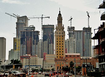 The early "Manhattanization" of downtown Miami, in 2007


See also
References
- ^ a b "Greater Downtown Miami Maps". Miami Downtown Development Authority.
- ^ "Demographia United States Central Business Districts" (PDF).
- ^ "Miami Downtown Development Authority: Subdistrict Boundaries" (PDF). Miami Downtown Development Authority. July 5, 2013. Archived from the original (PDF) on September 10, 2015. Retrieved November 23, 2015.
- ^ "Downtown Miami's Central Business District Office Buildings" (PDF). Miami Downtown Development Authority. February 22, 2010. Archived from the original (PDF) on November 25, 2011. Retrieved November 23, 2015.
- ^ Williams, Linda K.; George, Paul S. "South Florida: A Brief History". Historical Museum of South Florida. Archived from the original on April 29, 2010. Retrieved August 24, 2009.
- ^ Lackner, Catherine (October 20, 2015). "Flagler Street upgrade faces two hurdles". Miami Today. Retrieved November 24, 2015 – via miamitodaynews.com.
- ^ "Walk Score: Downtown Miami". Walk Score.