
Charleval, Eure
Charleval | |
|---|---|
 The church in Charleval | |
.svg) Coat of arms | |
Location of Charleval  | |
 Charleval  Charleval | |
| Coordinates: 49°22′18″N 1°23′02″E / 49.3717°N 1.3839°E | |
| Country | France |
| Region | Normandy |
| Department | Eure |
| Arrondissement | Les Andelys |
| Canton | Romilly-sur-Andelle |
| Government | |
| • Mayor (2020–2026) | Pascal Calais[1] |
| Area 1 | 14.14 km2 (5.46 sq mi) |
| Population (2021)[2] | 1,704 |
| • Density | 120/km2 (310/sq mi) |
| Time zone | UTC+01:00 (CET) |
| • Summer (DST) | UTC+02:00 (CEST) |
| INSEE/Postal code | 27151 /27380 |
| Elevation | 28–140 m (92–459 ft) (avg. 47 m or 154 ft) |
| 1 French Land Register data, which excludes lakes, ponds, glaciers > 1 km2 (0.386 sq mi or 247 acres) and river estuaries. | |
Charleval (French pronunciation: [ʃaʁləval]) is a commune in the Eure department in northern France.
History
Formerly known as Noyon-sur-Andelle, it was renamed Charleval in honour of King Charles IX.
The Château de Charleval (begun 1570, unfinished, disappeared) was designed by Jacques I Androuet du Cerceau, who engraved his designs and published them in 1579.[3]
Château de Charleval
-
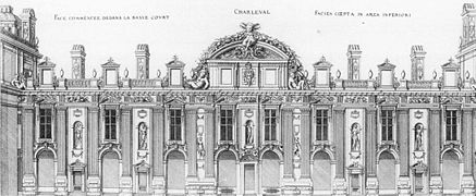 Court facade
 -
 General plan
_-_Ch%C3%A2teau,_Charleval_-_WGA00432.jpg)

Population
| Year | Pop. | ±% p.a. |
|---|---|---|
| 1968 | 1,636 | — |
| 1975 | 1,654 | +0.16% |
| 1982 | 1,753 | +0.83% |
| 1990 | 1,768 | +0.11% |
| 1999 | 1,872 | +0.64% |
| 2009 | 1,841 | −0.17% |
| 2014 | 1,833 | −0.09% |
| 2020 | 1,706 | −1.19% |
| Source: INSEE[4] | ||
See also
References
- ^ "Répertoire national des élus: les maires" (in French). data.gouv.fr, Plateforme ouverte des données publiques françaises. 13 September 2022.
- ^ "Populations légales 2021". The National Institute of Statistics and Economic Studies. 28 December 2023.
- ISBN 9780576154086). See also Commons:Category:Château de Charleval.
- ^ Population en historique depuis 1968, INSEE
Wikimedia Commons has media related to Charleval (Eure).
| International | |
|---|---|
| National | |
This Eure geographical article is a stub. You can help Wikipedia by expanding it. |