
Chilik (river)
| Chilik Shilik, Shelek | |
|---|---|
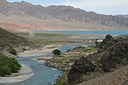
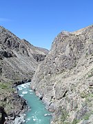
 Canyon of the Chilik River. May 2013 | |
 | |
| Native name | Шелек (Kazakh) |
| Location | |
| Country | Kazakhstan |
| Physical characteristics | |
| Source | Jangyryk glacier |
| • coordinates | 42°57′46″N 77°12′58″E / 42.9627°N 77.2160°E |
| Mouth | Ili |
• location | Kapchagay Reservoir |
• coordinates | 43°49′09″N 78°09′32″E / 43.8192°N 78.1590°E |
• elevation | Sea level |
| Length | 245 km (152 mi) |
| Basin size | 4,980 km2 (1,920 sq mi) |
| Discharge | |
| • average | 32.2 m3/s (1,140 cu ft/s) |
| Basin features | |
| Progression | Ili→ Lake Balkhash |
The Chilik[1] (Russian: Чилик, Kazakh: Шілік Shilik,[2] or Шелек Shelek) is a major flowing river in the Almaty Region in the Republic of Kazakhstan, one of the largest left tributaries of the Ili, and the main waterway of southeastern Kazakhstan. The Bartogay reservoir has been created on the river, from where the Great Almaty canal begins.[3]
Location
In the valley of the river is the village of Shelek with the same name, the former Administrative centre of the Chilik district of Almaty region (now merged with the Enbekshikazakh District). Also in the valley of the river are the villages of Malybai, Bijanova, Bayseit, Sarybulak, Milyanfan and Masak.
Current
The Chilik, in its upper course Jangyryk, is 245 kilometres (152 mi) long, and has a
Koksu River).[6]
-
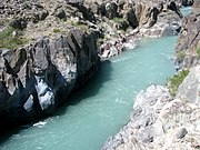
 Canyon of the Chilik River (May 2013)
 -
 Canyon of the Chilik River. (May, 2013)
 -
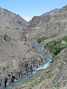 Canyon of the Chilik River. (May, 2013)
 -
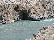 The shore of the river Chilik. Cave in the slope (May 2013)
 -
 Canyon of the Chilik River. Cliffs on the shore (May 2013)


References
- )
- )
- )
- ^ Чилик, Great Soviet Encyclopedia
- ISBN 9780121373016.
- )