
Ural (river)
| Ural | |
|---|---|
 | |
 | |
| Location | |
| Countries | Kazakhstan, Russia |
| Cities | Magnitogorsk, Orsk, Novotroitsk, Orenburg, Oral, Atyrau |
| Physical characteristics | |
| Source | |
| • location | Ural Mountains |
| Mouth | Caspian Sea |
• coordinates | 46°53′N 51°37′E / 46.883°N 51.617°E |
| Length | 2,428 km (1,509 mi) |
| Basin size | 231,000 km2 (89,000 sq mi) |
| Discharge | |
| • average | 400 m3/s (14,000 cu ft/s) |
| Official name | Ural River Delta and adjacent Caspian Sea coast |
| Designated | 10 March 2009 |
| Reference no. | 1856[1] |
The Ural (
The Ural rises near Mount Kruglaya in the Ural Mountains, flows south parallel and west of the north-flowing
Etymology
The river was called Δάϊκος (Daïkos) by
History

In the 10th to 16th centuries, the city of Saray-Jük (or Saraichik, meaning "small Sarai") on the Ural River (now in Atyrau Province of Kazakhstan) was an important trade center on the Silk Road. In the 13th century, it became a stronghold of the Golden Horde. It was destroyed in 1395 by the army of Timur but then rebuilt to become the capital of Nogai Horde in the 15th and 16th centuries. It was finally reduced to a village in 1580 by the Ural Cossacks.[11][12]
After the Russian conquest of the Ural basin in the late 16th century, the shores of the Ural became home to the
The Ural Cossacks (known originally as the Yaik Cossacks) resented the attempts by the central government to impose rules and regulations on them, and on occasions rose in rebellions. The largest rebellion, the Pugachev's Rebellion of 1773–75, involved not only the Ural, but much of south-eastern Russia, and resulted in a loss of the government control there. After its suppression, Empress Catherine issued a decree of 15 January 1775 to rename most of the places involved in the revolt, in order to erase the memory of it. Thus the Yaik River and the city of Yaitsk were renamed to the Ural River and Uralsk, respectively, and the Yaik Cossacks became the Ural Cossacks.[15]
On 6 April 2024, during the Snowmelt, a levee sheltering the city of Orsk broke.[16] A flood in Orenburg sets over 10.000 houses under water. Also parts of Kazakhstan are concerned.[16]
Geography

The river begins on the slopes of the Kruglaya Mountain
The tributaries, in order going upstream, are Kushum, Derkul,
The entire length of the Ural River is considered the
Hydrography

The river is mostly fed by melting snow (60–70%); the contribution of precipitation is relatively minor.[30] Most of its annual discharge (65%) occurs during the spring floods, which occur in March and April near the mouth and in late April through June upstream; 30% drain during the summer and autumn and 5% in winter. During the floods, the river widens to above 10 kilometres (6 mi) near Uralsk and to several tens of kilometers near the mouth. Water level is highest in later April upstream and in May downstream. Its fluctuation is 3 to 4 metres (10 to 13 ft) in the upper stream, 9 to 10 metres (30 to 33 ft) in the middle of the river and about 3 metres (10 ft) in the delta. The average water discharge is 104 cubic metres per second (3,700 cu ft/s) near Orenburg, and 400 cubic metres per second (14,000 cu ft/s) at the Kushum village, which is 76.5 kilometres (47.5 mi) from the mouth. The maximum discharge is 14,000 cubic metres per second (490,000 cu ft/s) and the minimum is 1.62 cubic metres per second (57 cu ft/s). Average turbidity is 280 grams per cubic metre (0.47 lb/cu yd) at Orenburg and 290 grams per cubic metre (0.49 lb/cu yd) near Kushum. The river freezes at the source in early November and in the middle and lower reaches in late November. It opens in the lower reaches in late March and in early April in the upper reaches. The ice drift is relatively short.[17][18][19]
The average depth is 1 to 1.5 metres (3 to 5 ft) near the source, and it increases in the middle reaches and especially near the mouth. The density of underwater vegetation also increases from the source to the mouth, so does the richness of the fauna. The bottom in the upper stream is rocky, with pebble and sand; it changes to silt-sand and occasionally clay downstream. The basin is asymmetrical – its left side from the river is 2.1 times larger in area than the right side; however, the right side is more important for feeding the river. The density of the tributaries is 0.29 km/km2 in the right and 0.19 km/km2 in the left side of the basin. The right-side tributaries are typical mountain rivers whereas the left-side tributaries have flatland character. About 200 kilometres (120 mi) from the mouth there is a dangerous spot for shipping called Kruglovskaya prorva (Russian: Кругловская прорва meaning Kruglovsk abyss). Here the river narrows and creates a strong vortex over a deep pit. The climate is continental with frequent and strong winds. Typical annual precipitation is 530 millimetres (21 in).[11][30]
Fauna
The wetlands at and near the delta of the Ural River are especially important to migrating birds as an important stop-over along the Asian flyway.
Ural River is also important for many fish species of the Caspian Sea which visit its delta and migrate upstream for spawning. In the lower reaches of the river there are 47 species from 13 families. The family Cyprinidae account for 40%, sturgeon and herring make up 11%, perch and herring 9% and salmon 4.4%. The main commercial species are sturgeon, roach, bream, perch, carp, asp and Wels catfish. The rare species include Caspian salmon, sterlet, white salmon and kutum.
In the delta of the river and nearby regions live about 48 animal species belonging to 7
The reptiles are represented by bog turtles, common water snakes, rat snakes and sand lizard. Bog turtles are found in all waters. Common water snakes live on the banks of canals. Rat snakes and sand lizards are few and inhabit relatively high areas of land. Two more reptiles, Caspian whipsnake and Coluber spinalis, are extremely rare. Among amphibians common are lake frog and green frog.[31]
With an estimated 5,000 to 10,000 species, insects exceed all other animals of the region by diversity and biomass. Terrestrial and aquatic insects make up a significant proportion of the diet of birds. Many species are parasitic on birds and transmit infection. Other dominating inhabitants of the river are
-
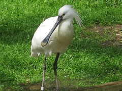 Eurasian spoonbill
 -
 Northern mole vole
 -
 Great gerbil
 -
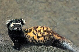 Marbled polecat
 -
 Sturgeon


Industry
Water from the upper reaches of the Ural River is used to supply the prominent Magnitogorsk (Magnitogorsk Iron and Steel Works, built in the early 1930s) and Orsk-Khalilovsk metallurgical plants, and the low reaches are used for irrigation. Two reservoirs were created near Magnitogorsk, and there is a hydroelectric plant near the village of Iriklinskaya with the corresponding reservoir. Below Uralsk, there is another reservoir and the Kushumsky channel. The river is navigated up to Uralsk and there is a port in Atyrau.[17][32] Fishery is well developed; the commercial fish species include sturgeon, perch, herring, bream, carp and catfish.[19] The delta of Ural River accounts for about half of the fish catchment in Kazakhstan.[31] Also widespread is agriculture, especially growth of melons and watermelons. The city of Atyrau is a major oil producing center of Kazakhstan.[11]
See also
Notes
References
- ^ "Ural River Delta and adjacent Caspian Sea coast". Ramsar Sites Information Service. Retrieved 25 April 2018.
- ^ a b c d Ural River Delta, Kazakhstan (NASA Earth Observatory)
- ^ Claudius Ptolemy (1843). "Book VI, chapter 14. Σκυθίας τῆς ἐντὸς Ἰμάου ὄρους θέσις". In Nobbe, Karl Friedrich August (ed.). Geographia (in Greek). Leipzig: Karl Tauchnitz. p. vol. 2, p. 122.
- ^ McCrindle, John Watson (1885). Ancient India as Described by Ptolemy. Bombay: Thacker, Spink. p. 290.
Rhymmos.
- ^ Yu. Kulakovsky. "Chapter 2. The map of European Sarmatia" (in Russian). Archived from the original on 30 July 2018. Retrieved 4 July 2010.
- ISBN 9781134430123.
- ^ "Onomastic survey in Eurasia. Finno-Ugric Place Names of Oldest Times".
- ^ Theodore Duka (1889). "The Ugor Branch of the Ural-Altaic Family of Languages". Journal of the Royal Asiatic Society. 21: 600.
- ^ Philippus Ferrarius; Michel-Antoine Baudrand (1738). Novum lexicon geographicum: in quo universi orbis, urbes, regiones ... flumina novis & antiquis nominibus appellata, suisque distantiis descripta recensetur (in Latin). p. 109.
- ^ B.A. Rybakov (1972). Русские летописцы и автор Слова о полку Игореве (in Russian). Nauka.
- ^ a b c d e f 800 km on Ural River (in Russian)
- ISBN 978-1-84162-234-7.
- ^ Zonn, p. 416
- ^ ""Багренье" (Bagrenye, i.e. Pike-pole fishing)". Энциклопедический лексикон (Encyclopedic lexicon) (in Russian). Vol. 4. Saint Petersburg. 1835. p. 65.
- ^ A.I. Poterpeeva & V.E. Chetin (1980). Revoliutsionnaia i trudovaia letopis Iuzhnouralskogo kraia: 1682–1918. South Ural.
- ^ a b Blaschke, Björn. "Russia: Dam burst on the Ural River - thousands of people evacuated". tagesschau.de (in German).
- ^ a b c Ural River, Encyclopædia Britannica
- ^ a b V. A. Balkov. Ural (in Russian). bashedu.ru
- ^ a b c d "Ural River" (in Russian). Great Soviet Encyclopedia.
- ^ Zonn, p. 375
- ^ "M-39 Topographic Chart (in Russian)". Retrieved 28 February 2023.
- ISBN 978-1-4262-0633-7. "Europe" (plate 59); "Asia" (plate 74): "A commonly accepted division between Asia and Europe ... is formed by the Ural Mountains, Ural River, Caspian Sea, Caucasus Mountains, and the Black Sea with its outlets, the Bosporus and Dardanelles."
- ^ World Factbook. Washington, DC: Central Intelligence Agency. 15 June 2022.
- ISBN 9780123694492.
- ISBN 0-631-22039-9.
- ^ Zonn, p. 178
- ^ "Orenburg bridge monument photos". katjasdacha.com.
- ^ Progress aplenty in Kazakhstan, uefa.com
- ^ Why Europe plays against Asians (in Russian). sport.ua (2008-09-10)
- ^ a b Ural River Archived 13 August 2011 at the Wayback Machine chelindustry.ru (in Russian)
- ^ a b c d e Фауна: Дельта реки Урал и прилегающее побережье Каспийского моря. wetlands.kz. (Fauna of the delta of Ural River, in Russian)
- ^ Zonn, p. 45
Bibliography
- Zonn, Igor S.; Kostianoy, Andrey & Kosarev, Aleksey N. (2010). The Caspian Sea Encyclopedia. Springer. ISBN 978-3-642-11523-3.