
Chorio, Othonoi
Chorio
Χωριό | |
|---|---|
Settlement | |
UTC+3 (EEST) | |
| Postal code | 49100 |
| Area code(s) | +30 26630 |
| Vehicle registration | KY |
| Website | diapontia.gr |
Chorio or Horio (
Designation
The settlement was called "Chorio" (English: village) because it was a densely populated area at the time. At the beginning of its existence there were not any other settlements on the island. This name continues until today.
The demonym of the locals is Chorianos - plural: Choriani (Greek: Χωριανός - Χωριανοί). All of them have the same surname (Katechis) as they are relatives.[5]
History
The first settlers of Othoni came from
The main work of the villagers was the olive and oil production as some of them had private oil presses next to their homes. Many of the male population of Chorio were seamen (captains, engineers etc.).[6]
Visitor attractions

The houses of Chorio are traditionally made with stone walls and ceramic roofs and they have a lot of similarities with the Corfiat traditional architecture although do not share the Venetian style. They rather tend to relate to the Epirus traditional architectural type. Each of them is close to each other as all the owners are relatives.
The orthodox church of Saint George was built in 18th century at the highest peak of Chorio hill, where everyone can enjoy the view of the other parts of the island, Corfu, Ereikoussa, Mathraki and Ionian sea. Plenty of visitors and locals are visiting the highest peak of Othoni, Imerovigli (392 m height) which is about 2 km on foot from the settlement. Its trail is reopened by private initiatives of "Choriani" and other locals.[7]
Another great place is "Iliovasilema" (sunset) which is about 200 m from Chorio with beautiful view of
Gallery
-
 Koukouli rock
 -
 Sunset, Chorio
 -
 Ztrila square, Chorio
 -
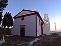 Saint George, Chorio

,_Chorio,_Othoni_island.jpg)


References
- ^ "Αποτελέσματα Απογραφής Πληθυσμού - Κατοικιών 2021, Μόνιμος Πληθυσμός κατά οικισμό" [Results of the 2021 Population - Housing Census, Permanent population by settlement] (in Greek). Hellenic Statistical Authority. 29 March 2024.
- ^ "Visit Greece | Othonoi". Visitgreece.gr. Archived from the original on 2016-10-03. Retrieved 2016-10-24.
- ^ "Othoni Island - Info in Greek". Omogenia.com. Archived from the original on 2011-08-14. Retrieved 2016-10-24.
- ISBN 960-7062-99-X. (page 27-28)
- ISBN 960-7062-99-X. (page 27)
- ISBN 960-7062-99-X. (page 27-28)
- ^ newmail.gr/ένωσαν-δυνάμεις-και-άνοιξαν-το-μονοπά