
Clyde Peak
| Clyde Peak | |
|---|---|
 Northeast aspect, reflected in Red Eagle Lake | |
| Highest point | |
| Elevation | 8,610 ft (2,624 m)[1] |
| Prominence | 770 ft (235 m)[1] |
| Parent peak | Mount Logan (9,244 ft)[2] |
| Isolation | 1.44 mi (2.32 km)[2] |
| Coordinates | 48°35′17″N 113°37′02″W / 48.58806°N 113.61722°W[1] |
| Naming | |
| Etymology | Norman Clyde |
| Geography | |
 Clyde Peak Location in Montana  Clyde Peak Location in the United States | |
| Location | class 3 scrambling[2] |
Clyde Peak is an 8,610-foot-elevation (2,620-meter) mountain summit located in
Etymology
The mountain's name commemorates Norman Clyde (1885–1972), who made the first ascent of this peak on July 23, 1923.[1] Clyde is credited with 130 first ascents, most of which were in the Sierra Nevada of California.[3] In 1923 he spent 36 days in Glacier National Park, Montana, where he climbed 36 mountains, including 11 first ascents. This geographical feature's name has not yet been officially adopted by the United States Board on Geographic Names.
Geology
Like other mountains in Glacier National Park, Clyde Peak is composed of sedimentary rock laid down during the Precambrian to Jurassic periods. Formed in shallow seas, this sedimentary rock was initially uplifted beginning 170 million years ago when the Lewis Overthrust fault pushed an enormous slab of precambrian rocks 3 mi (4.8 km) thick, 50 miles (80 km) wide and 160 miles (260 km) long over younger rock of the cretaceous period.[4]
Climate
According to the Köppen climate classification system, Clyde Peak is located in an alpine subarctic climate zone with long, cold, snowy winters, and cool to warm summers.[5] Winter temperatures can drop below −10 °F with wind chill factors below −30 °F. Due to its altitude, it receives precipitation all year, as snow in winter, and as thunderstorms in summer. This climate supports the Red Eagle Glacier remnant on the north slope of the peak.
Gallery
-
 Clyde Peak (left), Blackfoot Mountain (center), Mt. Logan (right).
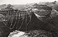
Aerial view from northeast, circa 1925. -
 South aspect of Clyde Peak (centered), with Logan upper left. 1914
 -
 North aspect of Clyde Peak, with Logan and Red Eagle Glaciers. 1914.
 -
 Aerial view of the west aspect of Clyde Peak (left side), circa 1930s


See also
- Mountains and mountain ranges of Glacier National Park (U.S.)
- Norman Clyde Peak
References
- ^ a b c d "Clyde Peak, Montana". Peakbagger.com. Retrieved 2021-08-20.
- ^ a b c "Clyde Peak - 8,610' MT". listsofjohn.com. Retrieved 2021-08-20.
- ^ Norman Clyde - Mountaineer, Owensvalleyhistory.com
- ^ Gadd, Ben (2008). "Geology of the Rocky Mountains and Columbias".
{{cite journal}}: Cite journal requires|journal=(help) - S2CID 9654551.
External links
- Weather forecast: National Weather Service
- Clyde Peak photo: Flickr