
Dhanmondi Thana
Dhanmondi
ধানমন্ডি | ||
|---|---|---|
Postal code[2] 1209 | ||
| Notable sport teams | Sheikh Jamal | |
Dhanmondi (
The origins of Dhanmondi can be traced back to the early 1950s, when the Government of East Pakistan developed it as a centrally planned residential area catering to the city's elites.
History
During the British colonial period, the area that is now Dhanmondi had a canal next to it and was primarily used for cultivation, interspersed with a few settlements. It was known for its rice (ধান, dhan in Bengali) and other grain seed markets. The term mandi in Persian and Urdu refers to a market or bazaar, hence the area came to be known as Dhanmondi.[6] By the 19th century, the canal dried up, making the market there less significant. Dhanmondi subsequently became forested and remained that way until the mid-twentieth century.[7]
In 1950, the government of East Pakistan acquired roughly 500 acres of agricultural and
Sheikh Mujibur Rahman, regarded as the founding father of Bangladesh, resided in Dhanmondi at road no. 32. He was assassinated along with most of his family at his residence on 15 August 1975. Today, his former residence has been converted into a memorial museum.[8]
Over the decades Dhanmondi evolved into a chic, miniature city, with hospitals to malls, schools, banks, offices and universities. After the liberation war, its neighbourhoods primarily consisted of two-story houses.[9] Dhanmondi Thana was formed in 1976.[10]
Geography
Dhanmondi Thana covers 4.34 km2 (1.68 sq mi), bordered by Mohammadpur Thana to the north, New Market Thana to the east and the south, Hazaribagh Thana to the south and the west. Sher-e-Bangla Nagar and Kalabagan thanas occupies the eastern border.[10]
Demographics
In the 2022 Bangladeshi census, Dhanmondi Thana recorded a total population of 101,937, distributed between the two city corporations. The Dhaka North section housed 75,148 residents, whereas Dhaka South accommodated 26,789 residents, with a combined total of 27,487 households and an average household size of 3.7 members. [4] The recorded population in 2022 reflects a decrease from the 2011 figures, which stood at 147,643 individuals.[5]
Points of interest
This section needs additional citations for verification. (May 2024) |
The most important roads in Dhanmondi are Road no. 27, Satmasjid Road and Mirpur Road.
Dhanmondi Lake
Exotic and delicious snack stalls along the lakeside, particularly on Road 2 (opposite the entrance to
During festivals such as
Banks
Almost every bank operating in the country has an outlet in Dhanmondi. Foreign banks such as HSBC and Standard Chartered also have branches there, with HSBC and Standard Chartered having multiple ATM booths within the area.
Restaurants
Dhanmondi is known for its wide range of expensive restaurants and cafes that mostly cluster around Satmasjid Road. Several local and international fast food chains in the country have outlets in this area. Most of these restaurants were opened in 2010s.
Dhanmondi is home to many renowned food chains, especially fast food.
Education
This section needs additional citations for verification. (September 2015) |
Over the last fifteen years, a large number of outstanding schools, colleges and private universities have been developed around the area.
Colleges like
Gallery
-
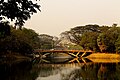 Bridge over Dhanmondi Lake
 -
 Dhanmondi Lake.
 -
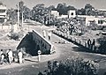 Dhanmondi 32 bridge in 1966
 -
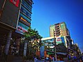 Shops and restaurants at Satmasjid Road


See also
References
- ^ "Geographic coordinates of Dhaka, Bangladesh". DATEANDTIME.INFO. Retrieved 7 July 2016.
- ^ "Dhaka Post Code". Directorate of Posts. Bangladesh National Portal. Retrieved 2024-05-09.
- Nikkei Inc.Retrieved 9 May 2024.
- ^ ISBN 978-9844752016.
- ^ a b National Report (PDF). Population & Housing Census 2011. Vol. 2. Bangladesh Bureau of Statistics. 2011. Archived from the original (PDF) on 3 September 2017. Retrieved 9 May 2024.
- OCLC 33970022.
- ISBN 984-412-104-3.
- ^ OL 30677644M. Retrieved 11 May 2024.
- ^ "আবাসিকের ঐতিহ্য হারাচ্ছে ধানমন্ডি" [Dhanmondi losing its residential tradition]. Prothom Alo (in Bengali). 6 January 2016. Retrieved 15 August 2022.
- ^ OL 30677644M. Retrieved 11 May 2024.
- ^ "Contact Details." Oxford International School. Retrieved 20 September 2015. "Main Campus (Attached Centre of Cambridge International Examination for CIPP, CLSP, Check Point, O Level and A Level examinations) House # 34, Road # 27 (old), New 16, Dhanmondi R/A, Dhaka-1209, "