
Drayton, Vale of White Horse
| Drayton | ||
|---|---|---|
Shire county | ||
| Region | ||
| Country | England | |
| Sovereign state | United Kingdom | |
| Post town | Abingdon | |
| Postcode district | OX14 | |
| Dialling code | 01235 | |
| Police | Thames Valley | |
| Fire | Oxfordshire | |
| Ambulance | South Central | |
| UK Parliament | ||
| Website | DraytonVillage.co.uk | |
Drayton is a village and
Archaeology
Two sites of former settlements in the parish are
Toponym
The earliest known forms of Drayton's toponym are the Old English Drægtune and Draigtun from the 10th century. It evolved through Draitune in the 10th and 11th centuries, Draitun from the 11th to the 13th century and Drettun in the 12th century. The current spelling of the name has been used since the 13th century.[6]
Manor
In 955 King Eadred granted 10 hides of land at Drayton to a thegn called Eadwold. Eadred's successors confirmed the grant. Eadwold left the estate to Abingdon Abbey but King Æthelred II, who was crowned in 978, seems to have held the manor, as in 983 he granted three hides of it to his butler, Wulfgar. In 1000 Æthelred granted the same three hides plus a watermill at Drayton to Abingdon Abbey. In the 11th century the land seems to have been divided into two manors: West and East Drayton.[6] The oldest parts of Drayton's current Manor House are 15th century. A wing was added in the 18th century and the front is early 20th century. The house is a Grade II* listed building.[7]
Churches
Church of England
The oldest parts of the
Chapels
A Baptist chapel was built in 1834 and is now Drayton Baptist Church.[6] A Wesleyan chapel was built in 1870[6] but is no longer used for worship.[11]
Economic and social history
Drayton had a watermill by 1000, when Wulfgar granted it in fee to
The route of the abandoned
Drayton is on what used to be the main road between
Amenities
Drayton has two
Twinning
Since 2000 Drayton has been twinned with Lesparre-Médoc, a commune in the French département of Gironde.[21]
Gallery
-
 Drayton Manor House. The wing on the left is 18th century. The range on the right is 15th century, behind an early 20th century front.
 -
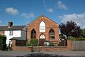 Drayton Baptist Church
 -
 69 High Street, a thatched 15th century cruck cottage
 -
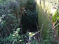 Ruined chamber of Drayton Lock on the abandoned Wilts & Berks Canal
 -
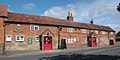 Red Lion
 -
 Wheatsheaf
 -

-
![44 High Street, a timber-framed 17th century farmhouse[22]](//upload.wikimedia.org/wikipedia/commons/thumb/4/4f/The_Old_Farmhouse_-_geograph.org.uk_-_832474.jpg/120px-The_Old_Farmhouse_-_geograph.org.uk_-_832474.jpg) 44 High Street, a timber-framed 17th century farmhouse[22]
44 High Street, a timber-framed 17th century farmhouse[22]


![44 High Street, a timber-framed 17th century farmhouse[22]](/File:The_Old_Farmhouse_-_geograph.org.uk_-_832474.jpg)
References
- Neighbourhood Statistics. Office for National Statistics. Retrieved 31 March 2015.
- ^ Historic England. "Sutton Wick settlement site (1003671)". National Heritage List for England. Retrieved 31 March 2015.
- ^ Historic England. "Settlement site (1004852)". National Heritage List for England. Retrieved 31 March 2015.
- ^ "In The Halls Of A Saxon King (Sutton Courtenay, Oxfordshire)". Time Team Series 17. Wessex Archaeology. 15 April 2011. Retrieved 31 March 2015.
- ^ Hinton 1970, p. 1.
- ^ a b c d e f g h i j Page & Ditchfield 1924, pp. 341–344.
- ^ Historic England. "The Manor House (Grade II*) (1052737)". National Heritage List for England. Retrieved 31 March 2015.
- ^ a b Pevsner 1966, p. 130.
- ^ Historic England. "Church of Saint Peter (Grade II*) (1052771)". National Heritage List for England. Retrieved 31 March 2015.
- Central Council for Church Bell Ringers. Retrieved 31 March 2015.
- ^ "Drayton (nr Abingdon)". Oxfordshire Churches & Chapels. Brian Curtis. Archived from the original on 21 February 2015. Retrieved 31 March 2015.
- ^ Fletcher 1968, p. 86.
- ^ Historic England. "69, High Street (Grade II) (1052735)". National Heritage List for England. Retrieved 31 March 2015.
- ^ Dalby 2000, p. 23.
- ^ Dalby 2000, p. 24.
- ^ Dalby 2000, pp. 95–96.
- ^ Rosevear, Alan. "Berkshire". Maps of Turnpike Roads by County. Retrieved 26 May 2015.
- ^ The Red Lion
- ^ Wheatsheaf Public House in Drayton Archived 2 April 2015 at the Wayback Machine
- ^ Drayton Community Primary School
- ^ Regal, Propos Georges (27 April 2010). "Subventions à la baisse, la grogne des associations". Journal Sud Ouest (in French). Retrieved 29 December 2010.
- ^ Historic England. "44, High Street (Grade II) (1052741)". National Heritage List for England. Retrieved 26 May 2015.
Sources
- Dalby, L.J. (2000) [1971]. The Wilts and Berks Canal (3rd ed.). Usk: Oakwood Press. ISBN 0-85361-562-4.
- Fletcher, John (1968). "Crucks In the West Berkshire and Oxford Region" (PDF). Oxoniensia. XXXIII. Oxford Architectural and Historical Society: 86.
- Hinton, David A (1970). "Two Late Saxon Swords" (PDF). Oxoniensia. XXXV. Oxford Architectural and Historical Society: 1–5.
- Page, W.H.; Ditchfield, P.H., eds. (1924). A History of the County of Berkshire. Victoria County History. Vol. 4. assisted by John Hautenville Cope. London: The St Katherine Press. pp. 341–344.
- Pevsner, Nikolaus (1966). Berkshire. The Buildings of England. Harmondsworth: Penguin Books. p. 130.