
East Central Texas forests
| East Central Texas forests | |
|---|---|
Nearctic | |
| Biome | Temperate broadleaf and mixed forests |
| Geography | |
| Area | 52,600 km2 (20,300 sq mi) |
| Country | United States |
| States |
|
| Climate type | Humid subtropical (Cfa) |
| Conservation | |
| Conservation status | Critical/endangered |
| Habitat loss | 75% |

Northern Post Oak Savanna 33a
Southern Post Oak Savanna 33b
San Antonio Prairie 33c
Northern Prairie Outliers 33d
Bastrop Lost Pines 33e
Floodplains and Low Terraces 33f
The East Central Texas forests or East Central Texas Plains (33) is a small temperate broadleaf and mixed forests ecoregion almost entirely within the state of Texas, United States.[1] The northern forests perimeter is partially within the southeast Oklahoma border.
Description
East Central Texas forests are distinguished from the adjacent
Subregions
Northern Post Oak Savanna
The landscapes of this ecoregion are generally more level and gently rolling compared to the more dissected and irregular topography of much of Southern Post Oak Savanna. It is underlain by mostly
Southern Post Oak Savanna
This ecoregion has more woods and forest than the adjacent prairie ecoregions, and consists of mostly hardwoods compared to the pines to the east in the South Central Plains. Historically a post oak
San Antonio Prairie
This ecoregion is a narrow, 100-mile long region occurring primarily on the
Northern Prairie Outliers
The small, disjunct areas of this ecoregion have a blend of characteristics from the
Bastrop Lost Pines
This ecoregion is an outlier of relict
Floodplains and Low Terraces
This ecoregion contains floodplain and low terrace deposits downstream from the
Fauna
The forests are home to a rich wildlife including
Conservation
This environment has been heavily altered by cattle ranching and clearance for farmland with only a quarter of the original habitats remaining, in fragmented patches and not in large blocks. There are no national forests in the region.
Gallery
-
 Oaks trees (Quercus) and wildflowers, Guadalupe County (October 2018).
 -
 Southern Post Oak Savannah habitat, Austin County, (March 2014).
 -
 Wild Turkey (Meleagris gallopavo), Austin County (January 2014).
 -
 Southern Post Oak Savannah, Colorado County (January 2014).
 -
 Southern Post Oak Savannah, Colorado County, (January 2014).
 -
 Texas spiny lizard (Sceloporus olivaceus) on a fencepost, Colorado County, (March 2017).
 -
 Lake Somerville State Park. Lee County, (May 2017).
 -
 Lake Somerville State Park, Lee County (May 2017).
 -
 Lake Somerville State Park, Lee County (May 2019).
 -
 Nails Creek, Somerville Public Hunting Lands, Lee County (April 2017).
 -
 Northern Bobwhite (Colinus virginianus), male right, female left, Colorado County (March 2017).
 -
 Northern Post Oak Savanna, Gus Engeling Wildlife Management Area, Anderson County (April 2017).
 -
 Northern Post Oak Savanna, Gus Engeling Wildlife Management Area, Anderson County (April 2017).
 -
 Little Bear Creek, Hays County (October 2010).
 -
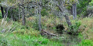
 Signs of beaver (Castor canadensis) activity, gnawed tree trunk and burrowing in stream bank. Madison County (March 2010).
_and_wildflowers,_Nockenut_Road,_Guadalupe_County,_Texas,_USA_(6_October_2018).jpg)
.jpg)
_Kuykend_Road,_Austin_County,_Texas,_USA_(30_January_2014).jpg)
,_Colorado_County,_Texas,_USA_(30_January_2014).jpg)
,_Colorado_County,_Texas,_USA_(30_January_2014).jpg)
_basking_on_a_fencepost,_Highway_102,_Colorado_County,_Texas,_USA_(26_March_2017).jpg)
.jpg)
.jpg)
.jpg)
.jpg)
,_male_right,_female_left,_Colorado_County,_Texas,_USA_(17_March_2017).jpg)
.jpg)
.jpg)
.jpg)
_activity,_private_land,_Madison_County,_Texas,_USA._(12_March_2010).jpg)
See also
References
- ^ a b c "East Central Texas forests". Terrestrial Ecoregions. World Wildlife Fund. Retrieved 2010-10-20.
- ^ a b World Wildlife Fund, ed. (2001). "East Central Texas forests". WildWorld Ecoregion Profile. National Geographic Society. Archived from the original on 2010-03-08. Retrieved 2010-10-20.
- ^ a b c d e f
 This article incorporates public domain material from Ecoregions of Texas poster, back (PDF). United States Geological Survey. Retrieved 2016-02-06.