
East Garston
| East Garston | |
|---|---|
Hungerford | |
| Postcode district | RG17 |
| Dialling code | 01488 |
| Police | Thames Valley |
| Fire | Royal Berkshire |
| Ambulance | South Central |
| UK Parliament | |
| Website | The Berkshire Village of East Garston |
East Garston is a village and
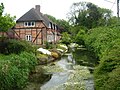
. The river flows through the village, dividing many houses from the main road, so that each has a bridge over the river to the front door.Government
The civil parish of East Garston comprises the village of East Garston, together with a considerable area of rural downland to the north and south. The parish has approximately 226 dwellings. In 2011 the population was 449,[1] in an area of 4,500 acres (18 km2).[2][3] The parish has boundaries with the Berkshire parishes of Fawley, Great Shefford, Hungerford and Lambourn, and with the Oxfordshire parish of Letcombe Bassett.[3]
Notable people
- Charles Thomas Wooldridge, murderer and dedicatee of The Ballad of Reading Gaol by Oscar Wilde, was born in the village.[citation needed]
Amenities
The Church of England parish church of All Saints is a flint built church dating back to the 12th century. Situated on the northwestern edge of the village, it is Grade II* listed.[4] The East Garston Bellringers was re-formed in 1998.
The village has a village hall, social club and cricket club, and is the home of the Garston Gallopers, a mixed
Demography
| Output area | Homes owned outright | Owned with a loan | Socially rented | Privately rented | Other | km2 roads | km2 water | km2 domestic gardens | Usual residents | km2 |
|---|---|---|---|---|---|---|---|---|---|---|
| Civil parish | 51 | 47 | 48 | 33 | 4 | 0.08 | 0.0001 | 0.13 | 459 | 8.05 |
Gallery of images
-
 Bridges over the River Lambourn
 -
 River Lambourn
 -
 East Garston Down


References
- ^ a b c "Key Statistics: Dwellings; Quick Statistics: Population Density; Physical Environment: Land Use Survey 2005". Archived from the original on 11 February 2003. Retrieved 5 December 2014.
- ^ East Garston.info (2007). "Welcome to the village of East Garston". Retrieved 10 January 2007.
- ^ a b "Election Maps". Ordnance Survey. Archived from the original on 7 March 2008. Retrieved 27 February 2008.
- ^ Historic England (6 February 1982). "Church of All Saints (Grade II*) (1321874)". National Heritage List for England.