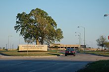
Easterwood Airport
Easterwood Airport | |||||||||||||||
|---|---|---|---|---|---|---|---|---|---|---|---|---|---|---|---|
AMSL 321 ft / 97.8 m | | ||||||||||||||
| Coordinates | 30°35′19″N 96°21′50″W / 30.58861°N 96.36389°W | ||||||||||||||
| Map | |||||||||||||||
| Runways | |||||||||||||||
| |||||||||||||||
| Statistics (2019) | |||||||||||||||
| |||||||||||||||
Easterwood Airport (
The William A. McKenzie Terminal at Easterwood Airport provides daily flights to
The ticket counters, TSA security checkpoint, and boarding areas are on the upper level of the terminal. Baggage claim and rental car agencies are on the lower level.
History
In 1938 the Board of Directors of the
In May 1940 the airport opened, named for U.S. Navy Lieutenant Jesse L. Easterwood. Easterwood was a former A&M student who enlisted in the British
The facility in 1940 had one hangar and a turf landing strip and taxiway which were eventually paved through funding provided by the CAA, the
In 1948 a large hangar was relocated to the airfield from a US Army flying field near
The first control tower was erected at the Airport in 1952 and a commercial passenger terminal was constructed in 1957. Work began on an extension of Runway 16-34 (now 17–35) to its present 7,000-foot (2,100 m) length in 1984. At the same time the parallel taxiway to Runway 16-34 was extended.
In 1988 work began on improvements to the Airport access road and construction of a new passenger terminal began. The new McKenzie Terminal opened in 1990 and plans were made to convert the old passenger terminal into a general aviation terminal. It was remodeled and re-opened for service in 1994 as a modern general aviation facility, housing line service and support personnel as well as flight operations.
Facilities

The airport covers 700 acres (280 hectares) and has two runways, 11/29, which is 5,158 by 146 feet (1,572 m × 45 m), asphalt and 17/35, which is 7,000 by 150 feet (2,134 m × 46 m), asphalt-concrete, all weather runway, an approach lighting system, an FAA control tower, FAA radio communication and an OmniRange-ILS Navigation Aid.[2]
In the year ending December 31, 2019, the airport had 56,749 aircraft operations, average 155 per day: 58% general aviation, 33% military, 9% air taxi and <1% airline. 50 aircraft were then based at this airport: 25 single-engine, 5 multi-engine, 18 jet and 2 helicopter.[2]
Transportation
No public transportation infrastructure is available at Easterwood. Thus, travelers must utilize private transportation options including taxis, rental car services, and ride sharing. Texas A&M University has a shuttle bus designated as "Route 7" that runs between the University campus and Easterwood Airport, and is only available to students, faculty, and Texas A&M hotel guests.[3] There are a few taxi companies registered with the City of College Station and the Easterwood Airport management. Rental car offices are located inside the terminal, while designated spaces for taxis and ride-shares are found outside.
Airline and destination
| Airlines | Destinations |
|---|---|
| Dallas/Fort Worth
|
| Destinations map |
|---|
Dallas/Fort Worth |
Statistics
| Rank | Airport | Passengers | Carriers |
|---|---|---|---|
| 1 | Dallas/Fort Worth, Texas
|
51,000 | American Eagle |
Accidents and incidents
- December 12, 1985: A GTE-owned Learjet 35A bound for Houston Hobby Airport rolled to the right and crashed right after take-off due to a catastrophic failure of the No. 2 engine, killing 2 out of the 3 onboard. Fatigue in the forward fan assembly was to blame and the inadequate maintenance standards of the manufacturer were a contributing factor.[8]
See also
References
- Thole, Lou (1999), Forgotten Fields of America : World War II Bases and Training, Then and Now – Vol. 2. Publisher: Pictorial Histories Pub, ISBN 1-57510-051-7
- ^ Easterwood Airport, official web site
- ^ PDF, effective 2016-02-04
- ^ a b "Bus Route 7 | Texas A&M Transportation Services". transport.tamu.edu. Retrieved November 8, 2019.
- ^ 1946 aerial view
- ^ "United Airlines to suspend service at Killeen, College Station airports". 4 November 2021.
- ^ "All scheduled direct (non-stop) flights from College Station (CLL)". flightsfrom.com. Retrieved May 1, 2023.
- ^ "RITA | BTS | Transtats". Transtats.bts.gov. Retrieved February 15, 2023.
- ^ "ASN Accident Description". Aviation Safety Network. Retrieved January 7, 2024.
External links
- Easterwood Airport, official website
- FAA Airport Diagram (PDF), effective April 18, 2024
- FAA Terminal Procedures for CLL, effective April 18, 2024
- Resources for this airport:
- AirNav airport information for KCLL
- ASN accident history for CLL
- FlightAware airport information and live flight tracker
- NOAA/NWS weather observations: current, past three days
- SkyVector aeronautical chart for KCLL
- FAA current CLL delay information


