
Emmerthal
You can help expand this article with text translated from the corresponding article in German. (June 2015) Click [show] for important translation instructions.
|
Emmerthal | |
|---|---|
 Coat of arms | |
Location of Emmerthal within Hameln-Pyrmont district 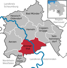 | |
 Emmerthal  Emmerthal | |
| Coordinates: 52°3′N 9°23′E / 52.050°N 9.383°E | |
| Country | Germany |
| State | Lower Saxony |
| District | Hameln-Pyrmont |
| Government | |
| • Mayor (2021–26) | Dominik Petters[1] (SPD) |
| Area | |
| • Total | 115 km2 (44 sq mi) |
| Elevation | 69 m (226 ft) |
| Population (2022-12-31)[2] | |
| • Total | 9,855 |
| • Density | 86/km2 (220/sq mi) |
| Time zone | UTC+01:00 (CET) |
| • Summer (DST) | UTC+02:00 (CEST) |
| Postal codes | 31860 |
| Dialling codes | 05155, 05157, 05286, 05151 |
| Vehicle registration | HM |
| Website | www.emmerthal.de |
Emmerthal is a municipality in the
Kirchohsen
.
In 1973, the Emmerthal was formed by merging the previously independent municipalities of
Welsede
.
The Grohnde Nuclear Power Plant is located in the Emmerthal.
From 1933 to 1937, the National Socialists held their national thanksgiving festival in a field on the nearby Bückeberg hill.
References
- Landesamt für Statistik Niedersachsen. 13 October 2021.
- Landesamt für Statistik Niedersachsen.
Towns and municipalities in Hameln-Pyrmont (district) | ||
|---|---|---|
 | ||
| International | |
|---|---|
| National | |