
Ernei
This article needs additional citations for verification. (August 2022) |
Ernei
Nagyernye | |
|---|---|
.jpg) Unitarian church in Călușeri | |
 Coat of arms | |
 Location in Mureș County | |
 Ernei Location in Romania | |
| Coordinates: 46°36′N 24°39′E / 46.600°N 24.650°E | |
| Country | Romania |
| County | Mureș |
| Government | |
| • Mayor (2020–2024) | Ferenc Jánosi[1] (UDMR) |
| Area | 67.78 km2 (26.17 sq mi) |
| Elevation | 334 m (1,096 ft) |
| Population (2021-12-01)[2] | 5,843 |
| • Density | 86/km2 (220/sq mi) |
| Time zone | EET/EEST (UTC+2/+3) |
| Postal code | 547215 |
| Area code | +40 x59 |
| Vehicle reg. | MS |
| Website | primariaernei |
Ernei (Hungarian: Nagyernye [ˈnɒɟɛrɲɛ]) is a commune in Mureș County, Transylvania, Romania, composed of six villages: Călușeri (Székelykál), Dumbrăvioara (Sáromberke), Ernei, Icland (Ikland), Săcăreni (Székes), and Sângeru de Pădure (Erdőszengyel).
Geography
The commune is situated on the Transylvanian Plateau, on the left bank of the Mureș River. It is located in the central part of the county, 11 km (6.8 mi) northeast of the county seat, Târgu Mureș, and forms part of the Târgu Mureș metropolitan area. Ernei is traversed by national road DN15, which connects Transylvania to Western Moldavia; the city of Reghin is 22 km (14 mi) to the north.
History
Ernei formed part of the Székely Land region of the historical Transylvania province. Until 1876, it fall within Marosszék, thereafter until 1918, the village belonged to the Maros-Torda County of the Kingdom of Hungary. After After the Hungarian–Romanian War of 1918–19 and the Treaty of Trianon of 1920, it became part of the Kingdom of Romania. As a result of the Second Vienna Award, it belonged to Hungary again between 1940 and 1944. After World War II, it returned to Romanian administration. Between 1952 and 1960, it formed part of the Magyar Autonomous Region, then, of the Mureș-Magyar Autonomous Region until it was abolished in 1968. Since then, the commune is part of Mureș County.
Demographics
The commune has an absolute
Broadcasting transmitter
South of Ernei at 46°35'35"N 24°38'0"E, there is a mediumwave transmitter working on 1323 kHz with a power of 15 kW. This transmitter occasionally broadcasts sometimes in German language.
Natives
See also
Notes
- ^ "Results of the 2020 local elections". Central Electoral Bureau. Retrieved 11 June 2021.
- ^ "Populaţia rezidentă după grupa de vârstă, pe județe și municipii, orașe, comune, la 1 decembrie 2021" (XLS). National Institute of Statistics.
External links
- Nagyernye Reformed Church Congregation Archived 2017-09-20 at the Wayback Machine (in Hungarian)
-
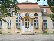 Teleki castle in Dumbrăvioara
 -
 Archangels' hermitage in Dumbrăvioara
 -
 Orthodox church in Ernei
 -
 Church in Sângeru de Pădure
.jpg)
.jpg)
.jpg)
.jpg)
