Eromanga Sea

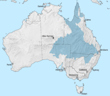
The Eromanga Sea was an inland sea across what would be Australia that formed in the Early Cretaceous. The sea reached the Eromanga Basin from the north via the Carpentarian Basin. The southern end of the sea comprised lagoons and rivers, and to the east in Surat Basin a bay.[1][2]
It covered large parts of Queensland and Central Australia at least four times during the early Cretaceous.[citation needed] The Winton Formation represent remnants of the river plains that filled the basin left by the Eromanga Sea. The formation is a major source of dinosaur fossils.
Opals
The
volcaniclastic sediments eroded from the Cordillera's volcanic arc. A theory was proposed explaining the abundance of opals in GAB. It was suggested that the Eromanga Sea was shallow, cold, muddy, and stagnant, which have led to little amount of carbonates in sediments in the Eromanga Basin. However the abundance of iron-rich and organic sediments have led to an anoxic sub-seafloor well-suited for anaerobic, pyrite-producing bacteria. It was suggested that during the periods of uplift, erosion, and denudation opals were formed due to acidic oxidative weathering during 97 to 60 Ma.[3][4][5]
References
- .
- ^ EROMANGA SEA
- ^ MINERAL TREASURES - OPAL
- ^ Tao Hsu, Andrew Lucas, and Vincent Pardieu SPLENDOR IN THE OUTBACK: A VISIT TO AUSTRALIA’S OPAL FIELDS
