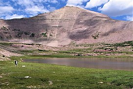
Explorer Peak
| Explorer Peak | |
|---|---|
 Southeast aspect, from Ottoson Basin | |
| Highest point | |
| Elevation | 12,708 ft (3,873 m)[1] |
| Prominence | 668 ft (204 m)[2] |
| Parent peak | Kweeyahgut Peak (12,855 ft)[3] |
| Isolation | 1.25 mi (2.01 km)[3] |
| Coordinates | 40°43′05″N 110°38′39″W / 40.7181748°N 110.6440433°W[4] |
| Geography | |
| Location | class 2 scrambling[3] |
Explorer Peak is a 12,708-foot elevation (3,873 m) mountain summit located in Duchesne County, Utah, United States.
Description
Explorer Peak is set within the
U.S. Board on Geographic Names to honor the Explorer Scouts.[6]

Climate
Based on the Köppen climate classification, Explorer Peak is located in a subarctic climate zone with cold snowy winters and mild summers.[7] Tundra climate characterizes the summit and highest slopes.
See also
References
- ^ United States Geological Survey topographical map - Explorer Peak
- ^ "Explorer Peak, Utah". Peakbagger.com. Retrieved 2022-08-06.
- ^ a b c "Explorer Peak - 12,708' UT". listsofjohn.com. Retrieved 2022-08-06.
- ^ "Explorer Peak". Geographic Names Information System. United States Geological Survey, United States Department of the Interior. Retrieved 2022-08-06.
- ^ Utah 12,000-foot Peaks, peakbagger.com
- ^ United States Board on Geographic Names (1957), Decisions on Names in the United States, Decision List 5701, Department of the Interior, p. 10
- S2CID 9654551.
External links
- Explorer Peak: weather forecast


