Fürstenfeld
You can help expand this article with text translated from the corresponding article in German. (May 2010) Click [show] for important translation instructions.
|
Fürstenfeld | ||
|---|---|---|
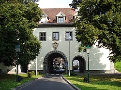
 Graz Gate, part of former town fortifications | ||
|
Postal code 8280 | ||
| Area code | +43 3382 | |
| Vehicle registration | HF | |
| Website | www.fuerstenfeld.at | |
Fürstenfeld (German pronunciation: .
According to the 2005 census, Fürstenfeld has 5,986 citizens within its communal area, the larger urban area of Fürstenfeld includes approximately 20% more citizens. It was the centre of an eponymous district until the end of 2012, when it was merged with Hartberg to form Hartberg-Fürstenfeld District.
Fürstenfeld was founded around 1170 as a fortress and received its town charter in 1215. Today it is known for its schools, middle-sized industry, and vicinity to several
Geography
Fürstenfeld is located in the lower Feistritz valley near the Burgenland border. Elevation of the urban area ranges from 255m to approximately 300 m ü. A. The city`s central part sits on a river terrace two dozen meters above the valley floor.
History
Neolithic age. There are numerous Urnfield culture archaeological finds and the Romans also found their way into the later Province of Noricum bordering their Pannonia province. From the 6th century on, Slavs diffused into the Pannonic region and were followed by Bavarian settlers in the 8th century.
Twin towns — sister citiesFürstenfeld is twinned with:[3] Notable people
References
External links
Wikivoyage has a travel guide for Fürstenfeld. Wikimedia Commons has media related to Fürstenfeld. |
