Faray
| Old Norse name | Færey |
|---|---|
| Meaning of name | Old Norse sheep island |
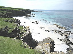
 Long Sand, situated on the western side of the island, facing Rapness Sound | |
| Location | |
| OS grid reference | HY531364 |
| Coordinates | 59°12′51″N 2°49′23″W / 59.2142°N 2.8231°W |
| Physical geography | |
| Island group | Orkney |
| Area | 180 ha (0.69 sq mi) |
| Area rank | 115= [1] |
| Highest elevation | 32 m (105 ft) |
| Administration | |
| Sovereign state | United Kingdom |
| Country | Scotland |
| Council area | Orkney Islands |
| Demographics | |
| Population | 0 |
| References | [2][3][4][5] |
Faray (Old Norse: Færey) is a small island in Orkney, Scotland, lying between Eday and Westray. Previously inhabited, the low-lying island is now a successful grey seal breeding colony.
Geography
Faray and Holm of Faray are formed of a ridge of Old Red Sandstone which extends southwards from Weather Ness at the southern tip of the island of Westray and almost connects Westray to Eday.[6] The two islands are separated by the Lavey Sound.
History

Faray was known as Pharay (or North Pharay to distinguish it from South Pharay, now called Fara). Both names are derived from the Old Norse 'faerey', "sheep island".[4]
The only man-made relic of note is a chambered cairn beside Lavey Sound. Faray had a population of eighty-two in 1861, falling to fifty-eight by 1891. By the late 1930s there were eight families living on the island. They had crofts and supplemented their income by lobster fishing. World War II led to many departures. By 1947 the last islander had left Faray and, apart from occasional summer occupation, the island was deserted.[7] A road still runs up the central spine of the island serving the scattered empty houses.

In December 1908 the Hope, a fishing vessel from Peterhead, ran aground on the Holm of Faray during a storm. The 'Five Men of Faray' braved the storm to row across the Lavey Sound and rescue the crew stranded on the rocks. They were rewarded with a trip to the Scottish mainland to meet Edward VII at Balmoral, where they each received a medal, together with "a good pipe and some tobacco".[6]
Conservation
The island is now populated by sheep, seabirds, and grey seals.[8] Faray and neighbouring Holm of Faray are designated a Special Area of Conservation for a well-established grey seal (Halichoerus grypus) breeding colony. The islands support the second-largest breeding colony in the UK, contributing around 9% of the annual UK pup production.[9]
Footnotes
- 2011 census.
- ISBN 978-1-84195-454-7.
- ^ Ordnance Survey. OS Maps Online (Map). 1:25,000. Leisure.
- ^ ISBN 0-901824-25-9
- ^ Pedersen, Roy (January 1992) Orkneyjar ok Katanes (map, Inverness, Nevis Print)
- ^ a b Julia Welstead (16 July 2005). "The heroic five men of Faray". The Scotsman. Retrieved 9 December 2007.
- ^ "Faray". lonelyisles.com. Retrieved 9 December 2007. [dead link]
- ^ "Faray". everything.com. Retrieved 9 December 2007.
- ^ "Faray and Holm of Faray". JNCC. Retrieved 9 December 2007.

