
Flekkerøy
Distrikt Flekkerøy
Flekkerøya | ||
|---|---|---|
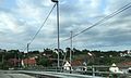
 View of the island | ||
|
Region Southern Norway | | |
| County | Agder | |
| City | Kristiansand | |
| Borough | Vågsbygd | |
| Area | ||
| • Total | 6.2 km2 (2.4 sq mi) | |
| Elevation | 13 m (43 ft) | |
| Population (2014) | ||
| • Total | 3,632 | |
| Time zone | UTC+01:00 (CET) | |
| • Summer (DST) | UTC+02:00 (CEST) | |
| ISO 3166 code | NO-030112 | |
| Website | kristiansand.kommune.no | |
Flekkerøy or Flekkerøya is an
History
Since the 15th century, Flekkerøy was an important harbour along the
In the early 17th century, the harbour again became of strategic importance, and in 1635 the island was visited by King
In 1807, about 250 people lived on the island, and in September 1807, English ships anchored at the harbour. The local people fled, Fredriksholm fortress was blown up, and the island was pillaged.[4] In 1848, a cannon battery was built, but in 1872 it was abandoned, and in 1874 the partially rebuilt Fredriksholm fortress was also closed down for good.
In 2005, the remaining military properties on Flekkerøya were secured for public outdoor recreation by the Ministry of Climate and Environment.[5]
Politics
The 10 largest politics parties in Flekkerøy (2015):
| Kristiansand city council votes from Flekkerøy 2015[6] | |
| Christian Democratic Party | 48,4% (704 votes) |
| Conservative Party | 17,2% (250 votes) |
Labour Party |
12,6% (183 votes) |
| Progress Party | 7,4% (107 votes) |
The Democrats |
5,8% (83 votes) |
| Green Party | 2,3% (33 votes) |
| Liberal Party | 2,1% (31 votes) |
The Christians |
1,2% (18 votes) |
| Socialist Left Party | 1% (15 votes) |
| Centre | 0,5% (7 votes) |
| Others | 0,4% (5 votes) |
| Total | 1431 votes |
Transportation
The main bus stop on the island is at the roundabout where County Road 457 ends. Line 07 is the local line on the island.
| Line | Destination [7] |
|---|---|
| M1 | Flekkerøy - Sørlandsparken-Dyreparken IKEA |
| M1 | Flekkerøy - Kvadraturen |
| N2 | Flekkerøy - Voiebyen - Kvadraturen |
| 07 | Åshavn - Flekkerøy - Skålevik |
Notable people
- Audun Laading, bassist of English-based Her's, died 2019
Media gallery
-
 Flekkerøy (red) in the very southern part of Norway
 -
 Skålevik
 -
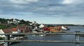 Skålevik
 -
 Flekkerøy coast
 -
 Old map of the Kristiansand harbour
 -
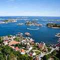 View of the coastline
 -
 Inside the Flekkerøy Tunnel


References
- ^ "Flekkerøya, Kristiansand (Vest-Agder)". yr.no. Retrieved 2017-01-23.
- ^ David Stevenson, Scotland's Last Royal Wedding (John Donald: Edinburgh, 1997), pp. 23-6.
- ^ "300 års militær aktivitet på Gammeløya" (in Norwegian).
- ^ "Historie om Flekkerøy" (in Norwegian).
- ^ "Forsvarseiendommer sikres til friluftsliv" (in Norwegian).
- ^ "VG - Valgnatt" (in Norwegian). vg.no. Retrieved 14 September 2015.
- ^ "AKT".
| Authority control databases: Geographic |
|---|