
Southern Norway
Southern Norway
Sørlandet | |
|---|---|
Region (landsdel) | |
          Descending, from top: EUR 24,000 |
Southern Norway (
The region includes coastal areas along the Skagerrak and extends inland to the Setesdalsheiene mountains. There are many large valleys running from the mountains to the south and east to the sea. The highest point in the region is Sæbyggjenuten at 1,507 m (4,944 ft).[3][2]
Etymology
Sørlandet refers to the region along the Skaggerak in southeastern Norway. This name should not be confused with the Norwegian term Sør-Norge which literally means
History
Southern Norway is the "youngest" of the many old regions within Norway; it was established shortly after the region of Northern Norway. The name Sørlandet was first used by the author Vilhelm Krag.[1] Krag proposed that Sørlandet should have been bigger than it is today, he suggested from Egersund to Grenland. The present day use of Sørlandet usually refers to an area smaller than that, but there is no official border. All the way back in 1865, it was talked about "the southern Norway boats".
The name and modern concept of this part of the country being considered as a separate region was introduced as late as 1902 by the local author Vilhelm Krag. Prior to this, the area was considered part of Western Norway.[1] Southern Norway coincides roughly with the historic petty kingdom of Agder, which lends its name to the two constituent counties: Vest-Agder and Aust-Agder, as well as the University of Agder.
If defined as an informal region, Southern Norway is perhaps more properly defined as the Skagerrak coastal belt, thus excluding the inland valleys to the north. Occasionally, adjacent parts of the county of Rogaland and Telemark might be considered part of this region, as well.
Traditionally, the easternmost border of Agder was Rygjarbit, which was thought to be Gjernestangen in the present-day municipality of Risør, but it could also be the strait between Askerøya and Lyngør in Tvedestrand.[7]
Transportation
| Year | Pop. | ±% |
|---|---|---|
| 1951 | 172,753 | — |
| 1960 | 185,302 | +7.3% |
| 1970 | 215,874 | +16.5% |
| 1980 | 225,429 | +4.4% |
| 1990 | 240,906 | +6.9% |
| 2000 | 257,869 | +7.0% |
| 2010 | 279,024 | +8.2% |
| Source: Statistics Norway [1][2]. | ||
Air
The Arendal Airport, Gullknapp is a general aviation airport located outside of Arendal city. The airport was founded in 1984 with a 500-metre (1,600 ft) long runway. Arendal Airport, Rådhuskaien is a former water airport in the cove of downtown Arendal, but it is now closed.
Farsund Airport, Lista is a former public airport located with Lista. It opened in 1941 and closed in 1999. The airport was located at Lista. Mandal Airfield is a former military owned airport that is now closed.
Bus
All bus lines and buses in Southern Norway are owned by
Roads
The
Sea
From the Kristiansand harbour, there are ferries from Kristiansand to Hirtshals in Denmark three times daily. In Arendal, there are local ferries to the island of Tromøya.
Train
Trains from Oslo to Stavanger go through the entire Southern Norway region. There are trains from
Economy
Key industries in Southern Norway are
List of municipalities
This section needs to be updated. (January 2020) |
About 80% of the population of the two counties live along the coast, which has the warmest climate in Norway as well as offering quick access to the rich fishing grounds and maritime routes of the Skagerrak.[2] In Southern Norway there are also a number of less populated inland municipalities. The list of the municipalities in Southern Norway are:


.svg)


Image gallery
-
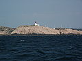
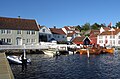
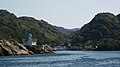 Kirkehavn on Hidra, Vest-Agder, Norway
 -
-
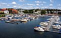
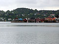 Arendal
 -
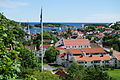 Risør
Risør -
-
 Kristiansand harbor


See also
- Demographics of Southern Norway
- Kashubian vetch- Sørlandsvikke (Kasjubiasvikke)
References
- ^ Store norske leksikon. "Sørlandet – landsdel"(in Norwegian). Retrieved 2010-04-15.
- ^ a b c d The Editors of Encyclopædia Britannica, ed. (2009-10-22), "Sorlandet", Encyclopædia Britannica, Encyclopædia Britannica, Inc., retrieved 2016-12-31
{{citation}}:|editor=has generic name (help) - ^ ut.no. "Sæbyggjenuten - Sørlandets høyeste punkt" (in Norwegian). Retrieved 2016-02-16.
- Store norske leksikon. Retrieved 2016-12-30.
- ^ "Statistics Norway - Church of Norway". Archived from the original on July 16, 2012.
- ^ "Statistics Norway - Members of religious and life stance communities outside the Church of Norway, by religion/life stance. County. 2006-2010".
- Store norske leksikon. "Rygjarbit"(in Norwegian). Retrieved 2016-12-30.
- Store norske leksikon. "Aust-Agder"(in Norwegian). Retrieved 2016-12-31.
- Store norske leksikon. "Vest-Agder"(in Norwegian). Retrieved 2016-12-31.
External links
- Southern Norway www.visitnorway.com
- Getting to Southern Norway and around
- Agder
- Visit Sørlandet
- University of Agder
- Tonal characteristics of some varieties of spoken South Norwegian.
| ||
| County |
|  |
|---|---|---|
| Cities and towns |
| |
| Larger urban areas (not towns or cities) | ||
| Municipalities | ||
| Regions | ||