
Fornham St Genevieve
| Fornham St Genevieve | ||
|---|---|---|
Shire county | ||
| Region | ||
| Country | England | |
| Sovereign state | United Kingdom | |
| Post town | Bury St Edmunds | |
| Postcode district | IP28 | |
| Police | Suffolk | |
| Fire | Suffolk | |
| Ambulance | East of England | |
Fornham St Genevieve is a village and
Location
The village is located around 500 metres (0.31 mi) north of Fornham St Martin and a 2.4 kilometres (1+1⁄2 mi) north of Bury St Edmunds. In 2005 its population was 110.[1] Its parish council is shared with neighbouring Fornham St Martin, and is known as Fornham St Martin cum St Genevieve Parish Council.[2]
Etymology
The village name is derived from the
History

The Domesday Book records that the population of Fornham St Genevieve in 1086 was 30 households.[4] The history of Fornham Park involved the scene of the Battle of Fornham in 1173. Robert Whitehand Earl of Leicester put up his final stand against the forces of Henry II near the church, and was subsequently captured and taken prisoner.[5][6]

Fornham St Genevieve as now seen was formed from the Fornham Hall estate, designed by Capability Brown.
The parish church was constructed around the 14th century from rubble flint, and included at least one memorial to the Tyldesley family. It was accidentally burned down on 19 May 1775, reputedly owing to the negligence of a man shooting jack daws that had lodged in the steeple. The remaining tower was Grade II* listed in 1955. Brown visited the estate after the fire and produced details plans for the estate, but died in 1783 before development could begin.[7][8] The manor house at Fornham no longer survives.
Transport
The B1106 is the main road through the village. Owing to an historical accident, there is now a roundabout in which four of the five exits have the same number.[9][10]
Gallery
-
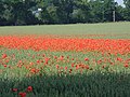 Poppy field at Fornham St Genevieve (2003)
 -
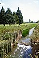 Old lock on River Lark (2005)
 -
 The Suffolk Golf Course (December 2007)
 -
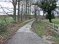 Mill Lane, Fornham St Genevieve (2012)
 -
 The Suffolk Golf Course at Fornham St Genevieve. British Sugar factory smoke in the distance (2007)
 -
 Heading south east, Timworth Carr (2015)


See also
References
- ^ a b Estimates of Total Population of Areas in Suffolk Archived December 19, 2008, at the Wayback Machine Suffolk County Council
- ^ "Parish Council". onesuffolk.net. Retrieved 4 March 2020.
- ^ "Key to English Place-names". Key to English Place-Names. Retrieved 14 June 2019.
- ^ "Fornham [St Genevieve]". Open Domesday. Retrieved 14 June 2019.
- ^ 'Fornham - Foulden', in A Topographical Dictionary of England, ed. Samuel Lewis (London, 1848), pp. 253-255. British History Online http://www.british-history.ac.uk/topographical-dict/england/pp253-255 [accessed 4 March 2020].
- ^ "Battle of Fornham: Call to remember historic Suffolk site". BBC Suffolk. Retrieved 19 October 2019.
- ^ Historic England. "CHURCH OF ST GENEVIEVE AT FORNHAM PARK (1376908)". National Heritage List for England. Retrieved 17 April 2014.
- ^ "Fornham St Genevieve". Tyldesley Family History. 29 June 2012. Retrieved 4 March 2020.
- ^ "The Island Shrine of St Genevieve". Rural Roads. Retrieved 4 March 2020.
- ^ "Fornham St Genevieve, Bury St Edmunds". Google Maps. Retrieved 4 March 2020.