
Forrabury and Minster
| Forrabury and Minster | |
|---|---|
Cornwall | |
| Ceremonial county | |
| Region | |
| Country | England |
| Sovereign state | United Kingdom |
Forrabury and Minster is a
civil parish on the north coast of Cornwall, England, United Kingdom.[1] The parish was originally divided between the coastal parish of Forrabury and inland parish of Minster until they were united on the 1st of April 1919.[2][3]
The parish was in the Registration District of Camelford. It is bounded to the north by the
Atlantic; to the east by the parishes of St Juliot, Lesnewth and Davidstow; to the south by Camelford parish (ecclesiastical parish of Lanteglos by Camelford); and to the west by Trevalga parish. The population of Forrabury and Minster parish in the 2001 census was 888, which decreased slightly to 838 at the 2011 census.[4]

Settlements and churches

Boscastle is the principal settlement in the parish of Forrabury and Minster. It is 14 miles (23 kilometres) south of Bude and 5 miles (8.0 kilometres) north-east of Tintagel. Forrabury parish church, dedicated to St Symphorian, is in Boscastle at grid reference SX 095 908.
However, the mother church of Boscastle is dedicated to St Materiana and nestles among the trees of Minster Wood in the valley of the
flood of August 2004 and in the following year archaeological work was done at the church to obtain a clearer idea of the history of the building.[6]
Notable buildings and antiquities
_(14777326862).jpg)
Minster church was built in Norman times (some late medieval additions and
Camelford railway station (now occupied by the British Cycling Museum) was built in 1893 and was closed in 1966. (Though named after nearby Camelford
it was in Minster parish.)
Views in Forrabury and Minster
-
 Forrabury and Minster: old lime kiln, Boscastle
 -
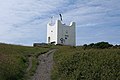 Forrabury and Minster: Coastwatch station, Willapark
 -
 Forrabury and Minster: Boscastle pier
 -
 Forrabury and Minster: Boscastle Old Mill or Bridge Mill


Bibliography
- Maclean, Sir John, The Parochial and Family History of the Parishes of Forrabury and Minster in the County of Cornwall, 1873 (part of MacLean's Parochial and Family History of ... Trigg Minor)
- Armstrong, W. J. C., A Rambler's Guide to Boscastle; Together with St Juliot, Lesnewth [and] Trevalga; 2nd ed., 1931, privately printed at Boscastle
References
- ISBN 978-0-319-23145-6
- Vision of Britain. Retrieved 7 March 2019.
- ^ "Camelford Registration District". UKBMD. Retrieved 7 March 2019.
- ^ "Parish population 2011 census". Retrieved 9 February 2015.
- ^ Burnard, William, History of Boscastle and Trevalga, Australia, 2007, p.53
- ^ Allan, John (2008) After the Flood: building recording at Minster Church, Boscastle, in 2005, in: Cornish Archaeology; 43-44 (2004-05), pp. 145-158
- ^ "Minster Church". Archived from the original on 7 October 2008. Retrieved 19 March 2009.
- ISBN 0-14-071001-9.
External links
Wikimedia Commons has media related to Forrabury and Minster.
| Unitary authorities | |
|---|---|
| Major settlements (cities in italics) |
|
| Rivers | |
| Topics | |