
Fort Batenstein
| Fort Batenstein | |
|---|---|
| Part of Dutch Gold Coast | |
 Drawing of Fort Batenstein by Hubertus Varlet (1841) | |
 Fort Batenstein | |
| Coordinates | 4°49′37″N 1°55′17″W / 4.826944°N 1.921389°W |
| Site history | |
| Built | 1656 |
| Garrison information | |
| Occupants | Netherlands (1656–1872) United Kingdom (1875–1957) Ghana (1957–Present) |
| Location | Butre, Western Region, Ghana |
| Part of | Forts and Castles, Volta, Greater Accra, Central and Western Regions |
| Criteria | Cultural: (vi) |
| Reference | 34-006 |
| Inscription | 1979 (3rd Session) |
Fort Batenstein was a fort and
At this fort, the
In 1979, the fort was designated a World Heritage Site (along with several other castles and forts in Ghana) because of its historical importance in European trade and exploitation in West Africa.[1]
Name
Batenstein literally translates to "profit fort," which historian Albert van Dantzig sees as evidence of a cynical sense of humour on the part of the directors of the Dutch West India Company: the fort at Komenda, which was the site of the fierce Komenda Wars with the British, was named Vredenburgh (literally "peace borough"), the commercially unsuccessful fort at Senya Beraku was named Goede Hoop ("Good Hope"), and the fort at Apam, which took five years to build due to local resistance, was named Lijdzaamheid ("Patience").[2]
History
Fort Batenstein was built by the Dutch West India Company, not because of promising trade opportunities in the area, but to crush the attempts of the
In the 18th century, a sawmill was constructed at Fort Batenstein, which provided the forts and ships in need of repair with wood.[4]
Fort Batenstein was not an important fort until 1837, when the Dutch–Ahanta War made it the focal point of Dutch military effort on the Coast. After the war, the Dutch made Ahanta a protectorate of which the commandant of Fort Batenstein was made the vice governor, thereby citing the provisions of the Treaty of Butre of 1656. In the years that followed, the Dutch attempted to establish a gold mine near Butre, which failed to produce any gold, however.[5][6]
After the Dutch
Gallery
-
 Fort Batenstein (by Gramberg, publ. 1861)
 -
 Map of the District of Butre, drawn in 1859
 -
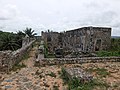
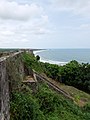
 The ruin of Fort Batenstein today
 -
 Picture of the top floor of Fort Batenstein
 -
 Picture of the entrance to Fort Batenstein
_p218_FORT_BATENSTEIN_TE_BOUTRIJ.jpg)
.jpg)


Notes
- ^ "Forts and Castles, Volta, Greater Accra, Central and Western Regions". UNESCO World Heritage Convention. Retrieved 9 Oct 2022.
- ^ Van Dantzig 2013, p. 178.
- ^ Van Dantzig 2013, pp. 178–179.
- ^ Doortmont 2013, p. 90.
- ^ Van Dantzig 2013, pp. 181–182.
- ^ Doortmont 2013, p. 93.
- ^ Van Dantzig 2013, p. 182.
References
- Doortmont, Michel R. (2013). "The Dutch Forts at Axim and Butre: Buildings, people, politics". In Doortmont, Michel R.; Valsecchi, Pierluigi; Anquandah, James R. (eds.). The Ankobra Gold Route: Studies in the Historical Relationship between Western Ghana and the Dutch. Accra: The Ankobra Gold Route Project. pp. 63–96. ISBN 978-90-367-6210-6.
- ISBN 978-90-367-6210-6.