
Fort Decatur (Alabama)
| Fort Decatur | |
|---|---|
| Milstead, Alabama in United States | |
 Marker placed at the site of Fort Decatur by the Alabama Anthropological Society in 1931. | |
 Fort Decatur  Fort Decatur | |
| Coordinates | 32°26′49.9″N 85°53′05.0″W / 32.447194°N 85.884722°W |
| Type | Earthen fort |
| Site information | |
| Owner | Auburn University |
| Controlled by | Auburn University |
| Open to the public | No |
| Site history | |
| Built | March 1814 |
| Built by | United States Army |
| In use | 1814 |
| Battles/wars | Creek War |
| Events | Death of John Sevier |
Fort Decatur was an earthen fort established in March 1814 on the banks of the Tallapoosa River as part of the Creek War and the larger War of 1812. The fort was located on the east bank of the Tallapoosa River, near the modern community of Milstead.[1] Fort Decatur was also located near the Creek town of Tukabatchee. It was most likely named for Stephen Decatur.[2]
History
Creek War
Colonel Homer Milton, the commanding officer of the
William McIntosh and Thomas Simpson Woodward were both temporarily stationed at Fort Decatur.[5]
Postwar
In 1815, President James Madison appointed Colonel John Sevier to the United States Boundary Commission to survey the boundary between the United States and the Creek Nation. The Commission was headquartered at Fort Decatur. On September 24, 1815, Sevier died and was buried at Fort Decatur. Sevier's remains were reinterred at the Knox County Courthouse in Knoxville on June 15, 1889.[11]
A post office operated under the name Fort Decatur from 1839 to 1859.[12]
Present
Today, the fort site is marked by a historical marker that was placed by the Alabama Anthropological Society in 1931. The remains of the fort are located on the grounds of Auburn University's E.V. Smith Research Center.[2]
Units
The 4th Regiment of East Tennessee Militia and a battalion of West Tennessee Militia were both stationed at Fort Decatur.[13] The 7th North Carolina Militia was garrisoned at Fort Burrows and Fort Decatur.[14]
Gallery
-
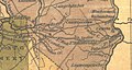 Fort Decatur (located in the center) as portrayed in Henry Schenck Tanner's 1830 The Traveler's Pocket Map of Alabama.
 -
 1889 photograph of John Sevier's original grave at Fort Decatur prior to disinterment. Tennessee governor Robert Love Taylor is leaning on the left corner of the fence and Alabama governor Thomas Seay is leaning on the right corner.
 -
 2017 LiDAR hillshade of Fort Decatur (in the lower right) and Fort Burrows (upper left), with the Tallapoosa River in the center of the image.


References
- ^ Harris 1977, pp. 40.
- ^ a b Bunn & Williams 2008, pp. 59.
- ^ Waselkov & Christopher 2012, pp. 208.
- ^ Owsley 2008, pp. 60.
- ^ a b Brannon, Peter A. (September 20, 1931). "Fort Decatur". The Montgomery Advertiser. Montgomery, Alabama. Retrieved September 7, 2021.
- ^ Jones 2006, pp. 113.
- ^ Hannings 2012, pp. 205.
- ^ Brown 1900, pp. 122.
- ^ Pinckney 1926, pp. 501.
- ^ Jackson 1927, pp. 26.
- ^ Williams 1924, pp. 284.
- ^ "Macon County". Jim Forte Postal History. Retrieved 3 April 2020.
- ^ Kanon, Tom. "Regimental Histories of Tennessee Units During the War of 1812". Tennessee State Library and Archives. State of Tennessee. Retrieved 9 August 2020.
- ^ Goss, Bill. "Early Forts Stand Stalwart". The Wetumpka Herald. Retrieved 3 April 2020.
Sources
- Brown, William Garrott (1900). A History of Alabama, for Use in Schools: Based as to Its Earlier Parts on the Work of Albert J. Pickett. New York, New York: University Publishing Company. ISBN 9781172237579.
- Bunn, Mike; Williams, Clay (2008). Battle for the Southern Frontier: The Creek War and the War of 1812. Charleston, South Caroline: The History Press. ISBN 978-1-62584-381-4.
- Hannings, Bud (2012). The War of 1812: A Complete Chronology with Biographies of 63 General Officers. Jefferson, North Carolina: McFarland. ISBN 978-0-7864-6385-5.
- Harris, W. Stuart (1977). Dead Towns of Alabama. Tuscaloosa, Alabama: University of Alabama Press. ISBN 0-8173-1125-4.
- Jackson, Andrew (1927) [Composed 10 August 1814]. Bassett, John Spencer (ed.). Correspondence of Andrew Jackson. Vol. 2. Washington, D.C.: Carnegie Institution of Washington.
- Jones, Randell (2006). In the Footsteps of Davy Crockett. Winston-Salem, North Carolina: John F. Blair. ISBN 978-0-89587-324-8.
- Owsley, Frank Lawrence (2008). Struggle for the Gulf Borderlands. Gainesville, Florida: Library Press@UF. ISBN 978-1-947372-34-4.
- Pinckney, Thomas (1926) [Composed 14 April 1814]. Bassett, John Spencer (ed.). Correspondence of Andrew Jackson. Vol. 1. Washington, D.C.: Carnegie Institution of Washington.
- Waselkov, Gregory; Christopher, Raven (April 2012). Archaeological Survey of the Old Federal Road in Alabama (Technical report). Montgomery, Alabama: Alabama Department of Transportation.
Submitted by the Center for Archaeological Studies University of South Alabama.
- ISBN 9780806347400.