
Fort Frederica National Monument
| Fort Frederica National Monument | |
|---|---|
St. Simons Island, Georgia, USA | |
| Nearest city | Brunswick, Georgia |
| Coordinates | 31°13′26″N 81°23′36″W / 31.22384°N 81.39324°W |
| Area | 284.49 acres (115.13 ha)[1] |
| Authorized | May 26, 1936 |
| Visitors | 293,041 (in 2011)[2] |
| Governing body | National Park Service |
| Website | Fort Frederica National Monument |
 Fort Frederica in 2020 | |
| Nearest city | Brunswick, Georgia |
| Area | 218 acres (88.2 ha) |
| Built | 1736 |
| NRHP reference No. | 66000065[3] (original) 100005351 (increase) |
| Significant dates | |
| Added to NRHP | October 15, 1966 |
| Boundary increase | July 23, 2020 |
Fort Frederica National Monument, on
A town of up to 500 colonial residents had grown up outside the fort; it was laid out following principles of the
History
In the early 18th century, Europeans called the land lying between
In the 1742 battles of Bloody Marsh and Gully Hole Creek, forces under Oglethorpe successfully repulsed Spanish attempts to invade St. Simons Island. Afterward the Spanish no longer threatened the colony; in 1749 the government disbanded the garrison at Frederica. Soon the village fell into economic decline, and by 1755 it was mostly abandoned. The town survived a fire in 1758, but after a few more years, it was abandoned.[5] Naturalist William Bartram visited the site in March, 1774. Though it was in ruins he noted that there was still a small garrison there.[6]
Fort Frederica was documented and authorized as a
Starting in 1947, the
As a historic area under the National Park Service, the National Monument was listed on the National Register of Historic Places on October 15, 1966. Fort Frederica is open to the public and admission is free.

Gallery
-
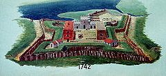 Historical layout of the colonial fort
 -
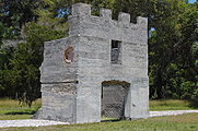
 The magazine of Fort Frederica
 -
 Fort Frederica on riverfront
 -
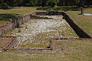
 Remains of Fort Frederica barracks
 -
 Remains of Frederica house
 -
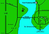 Modern map of the area
 -
 Historical layout of the town


Related sites
 Georgia (U.S. State) portal
- Fort Argyle
- Battle of Bloody Marsh
- Battle of Gully Hole Creek
- Castillo de San Marcos National Monument
- Fort Caroline National Memorial
- Fort King George
- Fort Matanzas National Monument
- Fort Morris State Historic Site
- Wormsloe Historic Site
- Oglethorpe Plan
- List of national monuments of the United States
Footnotes
- ^ "Listing of acreage – December 31, 2011" (XLSX). Land Resource Division, National Park Service. Retrieved 2012-05-13. (National Park Service Acreage Reports)
- ^ "NPS Annual Recreation Visits Report". National Park Service. Retrieved 2012-05-13.
- ^ "National Register Information System". National Register of Historic Places. National Park Service. July 9, 2010.
- ^ para.5, Testimony of NPS Deputy Director A.Durand Jones regarding HR. 1113. Archived 2008-10-05 at the Wayback Machine, Dept. of Interior, 2004, accessed 3 Sept 2008
- ^ para.6 Archived 2008-10-05 at the Wayback Machine, Dept. of Interior
- ^ T. B. BARTOW The Georgia Historical Quarterly Vol. 1, No. 4 (DECEMBER, 1917), pp. 347-349
- ^ para.7 Archived 2008-10-05 at the Wayback Machine
References
- The National Parks: Index 2001–2003. Washington: U.S. Department of the Interior.
External links
- Official NPS website: Fort Frederica National Monument
- Archeology at Fort Frederica National Monument
- "Frederica: An 18th-Century Planned Community", a National Park Service Teaching with Historic Places (TwHP) lesson plan
- Fort Frederica historical marker
 Media related to Fort Frederica National Monument at Wikimedia Commons