
Gaast
Gaast | ||
|---|---|---|
Village | ||
 Gaast | ||
|
Postal code 8757[1] | ||
| Dialing code | 0515 | |
Gaast is a village in
Friesland, the Netherlands. It had a population of around 220 in January 2017.[3]
History
The village was first mentioned in the 13th century as lutekagast, and means "geest (higher sandy ground)".[4] Gaast developed on a sand bank near the former Zuiderzee (nowadays: IJsselmeer).[5] Its proximity to the sea has caused problems. In 1643, the dyke broke. In 1702, it managed to hold on, however 23 ships off the coast sank near Gaast. The economy used to be based on fishing and sailing, however it has become an agricultural community.[6]
The Dutch Reformed church was built in the 14th century, and has been restored in 1916.[5][6]
Gaast was home to 217 people in 1840.[7] Before 2011, the village was part of the Wûnseradiel municipality.[7]
Gallery
-
 Church of Gaast
 -
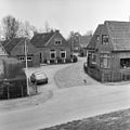
 Street of Gaast
 -
 Canal view
 -
 View from the dike (1979)


_(26639597799).jpg)

References
- ^ a b c "Kerncijfers wijken en buurten 2021". Central Bureau of Statistics. Retrieved 5 April 2022.
two entries
- ^ "Postcodetool for 8757JP". Actueel Hoogtebestand Nederland (in Dutch). Het Waterschapshuis. Retrieved 5 April 2022.
- ^ Kerncijfers wijken en buurten 2017 - CBS Statline
- ^ "Gaast - (geografische naam)". Etymologiebank (in Dutch). Retrieved 5 April 2022.
- ^ ISBN 90 400 9476 4. Retrieved 4 April 2022.
- ^ a b "Gaast". Friesland Wonderland (in Dutch). Retrieved 5 April 2022.
- ^ a b "Gaast". Plaatsengids (in Dutch). Retrieved 5 April 2022.
External links
![]() Media related to Gaast at Wikimedia Commons
Media related to Gaast at Wikimedia Commons